Richarte, D., Gimenez, M., Rapalini, A.
2 016
GEOACTA 41(1): 65-76 (2016)
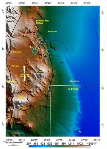
A partir de información gravimétrica, se realizaron mapas de anomalías de gravedad, análisis isostático y de espesor elástico, con el fin de caracterizar la estructura cortical del bloque San Rafael, situado al sur de la Provincia de Mendoza. De la interpretación del mapa de anomalía obtenido del modelo EGM2008 y de las ondulaciones del Moho, se observó que el bloque San Rafael se encuentra sobre un escalón tectónico. El Moho bajo el Bloque se ubica entre los 40 y 45 km de profundidad. Las diferencias entre las profundidades del Moho hidrostático y del Moho gravimétrico indican que existe una falta de raíz del orden de 8 km bajo el Bloque San Rafael, evidenciando una clara descompensación isostática, con carencia de raíz compensadora de la expresión topográfica del Bloque. Esto sumado a los valores de espesor elástico calculados, son indicadores de que la corteza tiene la suficiente rigidez como para soportar la carga del Bloque.
On the basis of gravimetric data, gravity anomaly maps were made, together with isostatic and elastic thickness analyses, with the aim of characterizing the crustal structure of the San Rafael block, situated in the south of the province of Mendoza. Based on the interpretation of anomaly map obtained of EGM2008 model and of the Moho undulations, it was observed that the San Rafael block is located on a tectonic slope. The Moho under the block is situated at a depth of 40- 45 km. The differences between the hydrostatic Moho and the gravimetric Moho results indicate a lack of a root of approximately 8 km under the San Rafael block, which shows a clear lack of isostatic equilibrium, with a lack of a root to compensate the topographic expression of the block. This, together with the elastic thickness values calculated, are indicators that show that the crust is rigid enough to support the block.