Geomorphology of the northeastern extreme of Isla Grande de Tierra del Fuego, Argentina
Luis Díaz Balocchi, Juan Federico Ponce, Alfonsina Tripaldi, Ignacio Magneres
2 020
Journal of Maps Volume 16, 2020 - Issue 2
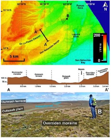
A 1:60,000 scale geomorphological map of the Argentine side of the northeastern extreme of Isla Grande de Tierra del Fuego in southernmost South America is presented. This paper describes and summarizes the geomorphology of the mapped area, which includes glacial, periglacial, fluvial, coastal, aeolian, lacustrine, and anthropogenic landforms that span over 680 km2 north of San Sebastián Bay in a sparsely populated semiarid and cold steppe used for sheep breeding and hydrocarbon extraction. We used Landsat-8, Sentinel-2, and ALOS-PALSAR satellite products combined with field validation to create the map. Glacial advances and retreats as well as climatic and sea level fluctuations that controlled fluvial systems and coastal dynamics were the main sculptors of the landscape during the Late Cenozoic. Aeolian, lacustrine, and anthropogenic activity were later minor contributors. The presented free, open access, vector geomorphological map is intended to be a supporting tool for multidisciplinary researchers and decision-makers.