Ethel Morales, Facundo Plenc, Josefina Marmisolle, Eduardo Rossello, Alejandro Oleaga, Rodrigo Umpiérrez
2 022
Tectonophysics - Volume 823, 20 January 2022
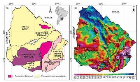
To understand the subsurface stratigraphy and structure of the Laguna Merín Basin (LMB), data from 42 magnetotelluric stations were interpreted by performing 1-D and 2-D inversions along three profiles perpendicular to the main basin borders. The Aiguá-India Muerta-Chuy Lineament (AICL) constitutes the southern boundary of the LMB and is characterised by a subvertical sinistral transtensional fault with a general orientation of N85°E. The basin's northern boundary, represented by the Cebollatí-Merín Lineament (CML), is characterised by a set of echelon dextral transpressional faults with a general orientation of N50°. Both faulting sets are associated with maximal horizontal stress oriented NE-SW. The infill of the LMB comprises thick Jurassic-Cretaceous igneous rocks (average of ~1500 m) overlying a crystalline Precambrian basement and overlain by ≤500 m-thick Cretaceous-Cenozoic sedimentary sequences. Likewise, a very deep (> 3500 m) conductive body was identified in the basement between the CML and AICL, coincident with the highest values of gravimetric Bouguer anomalies recorded in Uruguay. Shallow Cretaceous-Cenozoic sedimentary sequences show resistivities between 1 and 25 Ω.m, an average thickness of 250 m, and a maximum thickness of 500 m. The deeper Jurassic/Cretaceous igneous rocks show average resistivities between 40 and 252 Ω.m, and a maximum thickness of nearly 2000 m with intercalations of conductive layers (< 25 Ω.m) of unknown nature in the lower half of the basin infill. A tentative 3-D model is proposed to represent the early stage of magmatic emplacement during the opening of the South Atlantic Ocean.