Florencia N. Milanese, Augusto E. Rapalini, Lucía Sagripanti, Silvana Geuna, Mark J. Dekkers, Rodrigo Feo, Pablo Franceschinis, Donaldo Bran, Andrés Folguera
2 023
Journal of South American Earth Sciences Volume 124 , April 2023
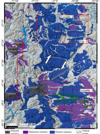
A paleomagnetic study performed in Plio-Pleistocene volcanic rocks of two localities in the Southern Central Andes is presented. The region corresponds to the transition zone between the Central and the Patagonian Andes. In the latter, deformation is almost exclusively controlled by the dextral-strike slip Liquiñe-Ofqui Fault Zone, that extends from ∼47 °S to ∼38 °S and accommodates the deformation generated by the oblique subduction of the Nazca Plate below South America. To the north of ∼36 °S, deformation is mainly contractional. Our study was carried out in the transition zone between both tectonic regimes. Sampling consisted of 31 paleomagnetic sites distributed in two localities: the Loncopué (∼38.0 °S, 70.7 °W) and Andacollo (∼37.2 °S, 70.8 °W) areas. We sampled Pliocene and Pleistocene volcanic rocks with ages younger than 5 Ma. After stepwise demagnetization and principal component analysis, site mean remanence directions were computed. Both localities show non-significant clockwise rotations of 1.7° ± 14.4° (Loncopué) and 8.1° ± 8.4° (Andacollo). Although the presently available database does not support significant tectonic rotation of the Andacollo lavas, preliminary results obtained from upper Miocene volcanics in a nearby area indicating ∼20° of clockwise rotation, encourage further studies to improve the resolution of the paleomagnetic data to determine if crustal block rotations have been, or still are, part of the Andean deformational processes. A revision of previously published paleomagnetic data in the northern Patagonian Andes suggests that, against original claims, no significant tectonic rotations associated to the Liquiñe-Ofqui Fault Zone, between ∼39 and 37.5 °S, can be unambiguously demonstrated.
Cecilia Gisela Cantera, Ana Elisabeth Tufo, Roberto Adrián Scasso & Maria dos Santos Afonso
2 022
Environmental Geochemistry and Health - 28 May 2021 Volume 44, pages 729–747, (2022)
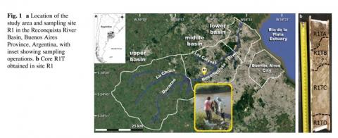
The mineralogical and geochemical characterization of sediments of the Reconquista River allows analyzing the geochemical partition of trace elements in one of the most polluted water courses of Argentina. The low dissolved oxygen and high ammonia contents, together with the high chemical oxygen demand, attest to the poor water quality. Ammonia, Cd and Cu content in surficial water exceeds the maximum guidelines for freshwater in Argentina. The recent sediments of the uppermost bed are enriched in organic matter (OM), sulfur, Zn, Cu and Pb. The enrichment factor is moderate, and the geoaccumulation index (Igeo) for Cu and Pb indicates uncontaminated to moderately contaminated sediments. The positive and significant correlation between As, Cr, Pb and Zn with the iron content suggests that their retention is controlled by the amount of iron oxy (hydr)oxides in the sediments, probably combined with the silt + clay abundance. In comparison with its tributary, the Las Catonas Stream, the Reconquista River, has less OM and trace elements in the sediments and more dissolved trace elements in the interstitial water. We interpret that OM is the main sorbent of the trace element. In the absence of OM, the iron oxy (hydr)oxides and the silt + clay fraction are a less efficient substitute. Consequently, the interstitial waters of the Reconquista River are enriched in these elements. Therefore, minor changes in the environmental conditions may generate significant release of hazardous trace elements from the sediments to the interstitial water and, in turn, to the surficial water of the river. As most of the big cities and the agricultural activities of Argentina are developed on the loessic substrate, the understanding of its interaction with polluted waters is crucial.
Renata Nela Tomezzoli, Ernesto O. Cristallini, Hugo Tickyj, Guadalupe Arzadún, Juan Martín Calvagno, Giselle Choque, Belen Febbo, Eliana Saguas
2 023
Front. Earth Sci., 07 November 2023 Sec. Geomagnetism and Paleomagnetism Volume 11-2023
Geological evidence indicates that the deformation along the southwest Gondwana margin began during the Middle-to-Late Devonian (the Acadian-Cháñica orogenic phase in Argentina). It has been interpreted that this deformation occurred as a consequence of the collision of Chilenia from the west and Patagonia from the south-southwest with Gondwana. As both Chilenia and Patagonia collided at the same time, in this study, we proposed that these continental blocks conform to the same allochthonous drift terrain, named here as CHIPA. The geological evolution of this margin is still under debate. Field work, paleomagnetic studies, and anisotropy of magnetic susceptibility (AMS) studies were integrated from different localities along this paleomargin in Argentina. In Permian rocks, all the geological indicators show a clear regional NW-SE elongation signature and NE-SW shortening direction. The middle Devonian to Permian patterns are more complex as the result of stress interference and the overlapping of orogenic activities with different intensities and ages. The deformation that started as the product of the CHIPA collision with Gondwana during the Middle Devonian continued through the Permian (the Hercinian-San Rafael orogenic phase in Argentina) as post-collisional compressive deformation, consequence of the paleogeographic re-organization of Gondwana and Laurentia, which moved toward the Equator from the south and the north, respectively, to form the Pangea supercontinent during the Triassic.
Lucas Arioni, Victor M. Velasco Herrera, Luiggina Cappellotto, Maria J. Orgeira, Claudia Prezzi, Eduardo A. Rossello
2 024
Journal of South American Earth Sciences Volume 145, 1 October 2024
Historical and instrumental seismicity from 1845 to the present was compiled for the Pampean regions of Argentina and Uruguay and the adjacent continental platform. These data were analyzed using the Gapped Wavelet Transform (GWT) with the aim of investigating recurrence patterns in the time series.
The GWT analysis reveals the existence of periods of seismic activity and periods of seismic silence within the considered area. A 22-year period was determined as the main pattern of seismic activity, during which earthquakes are registered only in 11 years. Based on these results, a probabilistic earthquake forecasting model was created using the Bayesian Machine Learning method, which suggests that the current seismically active period spans from 2011 to 2023 ± 1, with a cessation until 2034 ± 1, while the next seismically active period would begin in 2034 ± 2 ending in 2046 ± 2.
These periods or recurrence patterns are interpreted as intervals during which stress accumulates throughout intracrustal faults in the studied area, being then released through various events within the established temporal interval. The accumulation and release mechanisms are still a subject of debate. However, the earthquakes distribution suggests a sublatitudinal arrangement that tends to confirm some correspondence with the controlling faulting of the Quilmes Trough and others transtensional regional lineaments.
Gondwana Research Volume 132, August 2024, Pages 220-248
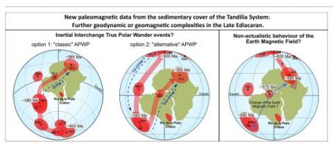
Anomalous paleomagnetic data have been found worldwide during the Ediacaran period, giving rise to several non-actualistic hypothesis. In order to get more information about this period, paleomagnetic, magnetic fabric and rock magnetic studies were carried out in the Avellaneda Formation (∼570–560 Ma) from two drill cores of the Alicia quarry in the Olavarría area of the Tandilia System, in the Río de la Plata craton (Argentina). Anisotropy of magnetic susceptibility studies indicate a pre-tectonic origin for the magnetic fabric of this Formation. Rock magnetic studies suggest the presence of magnetite and hematite in different proportions as the main ferromagnetic minerals carrying the remanence. After stepwise thermal demagnetization, two different characteristic remanence directions were obtained for the same unit, one corresponding to the marls (“b1”) of the lower section of the Avellaneda Formation, and the other from the claystones (“b2”) of the upper section of this unit. These results were combined with the remanence directions obtained by
Franceschinis et al. (2022)
for the same unit at La Cabañita quarry, located 10 km away. This procedure allows the calculation of two paleomagnetic poles for the Avellaneda Formation. The AV1 pole is located at: 2.0° S, 311.1° E, A95: 5.0°, N: 58 while the AV2 pole is at: 3.3° N, 348.9° E, A95: 11.7°, N: 7. These results confirms that the Rio de la Plata craton also presents anomalous paleomagnetic data during the Ediacaran, implying extremely fast movements in very short periods of time. This can be interpreted as evidence of two inertial interchange true polar wander events during this time, as was already proposed by other authors. An alternative possibility suggests a non-actualistic behaviour of the Earth Magnetic Field, switching from axial to equatorial positions, with an intermediate stable position between them. The likelihood and implications of these two hypotheses is discussed.
The magnitude and spatial variability of CO2 surface emissions and processes involving CO2 released to the atmosphere from the soils are relevant issues in the context of climate change. This work evaluated CO2 fluxes and 13C/12C ratio of vegetation, organic matter, and soil gases from no disturbed soils of Chaco Pampean Plain (Argentina) with different soil properties and environmental conditions (PL and PA units). Soil organic decomposition from individual layers was accompanied by δ13C of total organic carbon (δ13C-TOC) values more enriched to depth. δ13C-TOC values in the upper soil profile ~ ca. 0–15 cm were like the plant community of this area (~−33 to −29 ‰) while δ13C-TOC varied stronger bellow horizon A, till ~ −24‰. Both δ13C-TOC and soil δ13C-CO2 were similar (~ −24 to 26 ‰) at deeper horizons (~ 50–60 cm). Toward the superficial layers, δ13C-TOC and δ13C-CO2 showed more differences (till ~ 4 ‰), due influence of the diffusion process. Horizon A layer (~ 0–20 cm) from both PL and PA units contained the most enriched δ13C-CO2 values (~ −15–17 ‰) because atmospheric CO2 permeated the soil air. A simple two-component mixing model between sources (atmospheric δ13C-CO2 and soil CO2) confirmed that process. Isotopically, CO2 fluxes reflected the biodegradation of C3 plants (source), diffusive transport, and CO2 exchange (atmosphere/soil). Soil moisture content appeared as a determining factor in the diffusion process and the magnitude of CO2 surface emissions (12–60 g·m−2·d−1). That condition was confirmed by CO2 diffusion coefficients estimated by air-filled porosity parameters and soil radon gradient model.
Ignacio A. Capelli, Roberto A. Scasso, Jorge E. Spangenberg, Diego A. Kietzmann, Mercedes Prámparo, Thierry Adatte
2 024
Marine and Petroleum Geology Volume 163, May 2024,
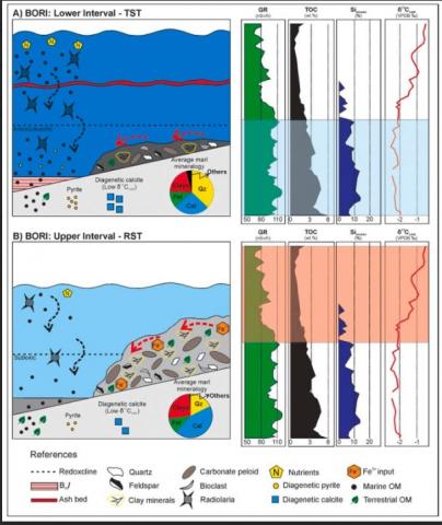
The 50 m-thick Berriasian organic-rich interval (BORI) of the Vaca Muerta Formation (Neuquén Basin, Argentina) represents one of the most attractive stratigraphic intervals for unconventional hydrocarbon exploration in the unit. Nevertheless, little is known about the environmental conditions prevailing during the accumulation of the sediments. To unravel the causes that favored the preservation of the organic matter (OM) in the BORI, a detailed multiproxy sedimentological approach was conducted. The study included the analyses of microfacies, palynological content, calpionellid-calcisphere dinocysts, mineralogy, spectral gamma-ray, inorganic geochemistry, Rock-Eval pyrolysis and stable carbon isotopes of whole rock carbonate (δ13Ccarb), and associated OM (δ13Corg). The BORI presents a late Early to early Late Berriasian age and is subdivided into a lower and upper interval. The lower interval (25.6 m-thick) is primarily formed by radiolaritic wackestones and presents higher total organic carbon (TOC) content (4.2 wt% on average), mainly in the form of amorphous OM (AOM), with variable contribution of phytoclasts. The geochemical analyses (Si, Ni, Cu, Mo, U, V) indicate high productivity of the water column and overall sea bottom anoxia. Oppositely, the upper interval (24.4 m-thick) is mostly constituted by peloidal packstones/grainstones and presents a lower TOC content (1.5 wt% on average) mainly constituted by phytoclasts, with variable contribution of AOM. A decrease of the productivity and an increase of sea bottom oxygenation is recorded based on the geochemical analyses. The high OM content of the BORI responds to the combination of high productivity of the water column and sea bottom anoxia in response to the Berriasian transgression and a worldwide paleoclimatic change towards more humid conditions. The results of our study position the BORI as an attractive interval for unconventional hydrocarbon production due to its high TOC, low bulk clay mineral and high biogenic quartz content, granting an adequate geomechanical behavior.
J. P. Ormazabal, S. Principi, F. I. Palma, D. M. Bran, J. I. Isola, F. D. Esteban, and A. A. Tassone
2 024
Journal of the Geological Society Volume 181, 23 May 2024
The North Scotia Ridge is the offshore morphostructural expression of the left-lateral transcurrent South America–Scotia plate boundary. Several blocks make up the ridge, including the scarcely studied Namuncurá Bank (also known as the Burdwood Bank). We present the first detailed study of active structures on the seafloor of the western Namuncurá Bank from a database of 3D and 2D seismic data, multibeam bathymetry and sub-bottom profiles. This work assesses the architecture, style of deformation and Cenozoic evolution of Namuncurá Bank, where several groups of faults and en echelon folding affect the seabed and shallow sub-bottom. These features compound the northernmost structures associated with a releasing bend, fitting well with a left-lateral Riedel shear model oriented at N74°E, slightly rotated with respect to the present day plate boundary stress regime. The current tectonic scenario started with a main deformational phase in the Neogene, partially distributed by the Malvinas fold–thrust belt, while modern deformation continues to be conditioned by pre-existing structures. This study allows a better understanding of the tectonics of the North Scotia Ridge, a morphostructure that influences the circulation of the Antarctic Circumpolar Current, thus impacting the global climate.
F. B. Restelli, J. G. Lozano, D. M. Bran, S. Bunicontro, E. Lodolo, A. A. Tassone, J. F. Vilas
2 024
Journal of Quaternary Sciences, Volume39, Issue5 July 2024 Pages 765-780
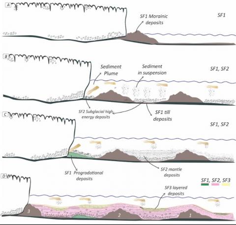
Lago Viedma is a proglacial lake into which the Viedma Glacier flows from the Southern Patagonian Ice Field. This glacier has rapidly lost mass in recent times, and its deglacial history is reflected in the lake's subsurface. New high-resolution multi-channel seismic profiles acquired in the northwestern sector of the lake have allowed us to reconstruct the bathymetry of the area and identify several small sub-basins, which have a maximum depth of 240 m in this sector. Four seismic facies have been recognized, separated by erosional unconformities, reflecting the depositional conditions in this sector of the basin during different Quaternary sedimentation phases. There is a transitional phase from ice-contacted deposits to subglacial deposits, probably associated with a subglacial fan, and finally a phase of lacustrine sedimentation. In addition, three depositional stages were identified within the lacustrine deposits, indicating a different sedimentary input, and the morphologies observed at the lake bottom suggest the existence of at least ten stagnations of the glacial margin. This study helps to improve the history of the retreat of the Viedma Glacier in this area during the Pleistocene/Holocene and provides a basis for further geophysical measurements aimed at mapping this remote lacustrine environment.
M. Emilia Bravo, M. Emilia Bravo, Miriam I. Brandt, Jesse M. A. van der Grient, Thomas G. Dahlgren, Patricia Esquete, Sabine Gollner, Daniel O. B. Jones, Lisa A. Levin, Craig R. McClain, Bhavani E. Narayanaswamy, Tracey Sutton, Lissette Victorero, Erik E. Cordes
2 022
Frontiers in Marine Science, 11 January 2023 Sec. Deep-Sea Environments and Ecology Volume 9 - 2022
The deep ocean comprises complex ecosystems made up of numerous community and habitat types that provide multiple services that benefit humans. As the industrialization of the deep sea proceeds, a standardized and robust set of methods and metrics need to be developed to monitor the baseline conditions and any anthropogenic and climate change-related impacts on biodiversity, ecosystem function, and ecosystem services. Here, we review what we have learned from studies involving offshore-energy industries, including state-of-the-art technologies and strategies for obtaining reliable metrics of deep-sea biodiversity and ecosystem function. An approach that includes the detection and monitoring of ecosystem services, with open access to baseline data from multiple sectors, can help to improve our global capacity for the management of the deep ocean.