Jorge G. Lozano, Donaldo M. Bran, Federica Donda, Emanuele Lodolo, Federico D. Esteban, Alejandro Tassone
2 021
Journal of Quaternary Science. Volume36, Issue2 February 2021 Pages 273-287
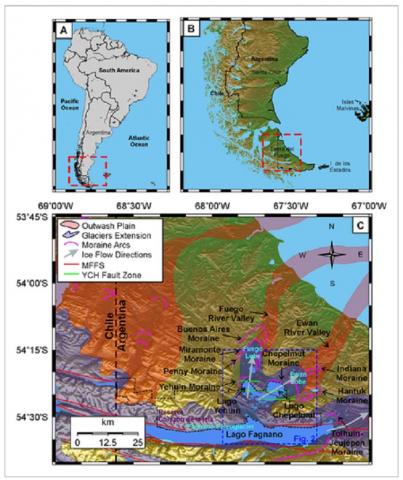
At ~20 ka bp, lakes Yehuin, Chepelmut and Fagnano constituted a single, large water body in the central part of Isla Grande de Tierra del Fuego (southernmost Patagonia). The evolutionary history of this lake, known as ‘Palaeolago Fueguino’, was probably controlled by the advances, stillstands and retreats of the ‘Fagnano Palaeoglacier’, an outlet glacier that flowed eastward from the Darwin Cordillera ice sheet. A detailed analysis of high-resolution seismic reflection profiles acquired within the three lakes has allowed the identification and correlation of seven unconformities within the lacustrine sedimentary infill, three seismostratigraphic sequences in Lago Fagnano and four in Lago Yehuin. A seismic stratigraphic correlation between these sequences suggests that these basins formerly constituted a single, large lacustrine body. A lake-level curve of the evolutionary stages of each lake, derived from the seismostratigraphic analysis of the sedimentary infill is proposed here, representing a 17.5 ka-long record. It was further integrated with the glacial record of the advances and retreats of the Fagnano Palaeoglacier. This study has implications for interpreting the sedimentary history of lake basins in glaciated mountain ranges.
Pedro Palermo, Claudia Gogorza, María J. Orgeira, María De Bernardi, María A. Irurzun, Ana M. Sinito, Romina Sanci, Andrea Coronato
2 021
Physics of the Earth and Planetary Interiors Volume 318, September 2021
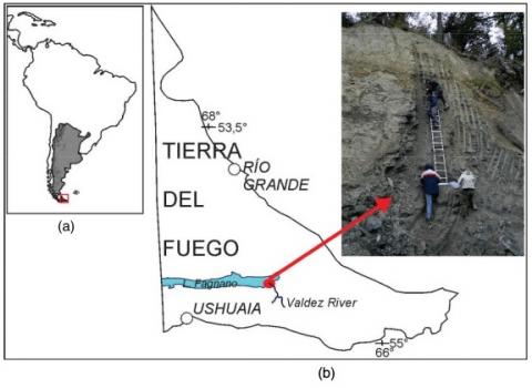
High-resolution paleomagnetic investigations were performed on Río Valdez outcrop at the Fagnano Lake, central Isla Grande de Tierra del Fuego, southernmost South America. Our aims were to develop a full-vector paleomagnetic secular variation (PSV) record and establish paleomagnetic chronostratigraphy for the outcrop based on radiocarbon dating and the correlation of the PSV record with other dated PSV records in the region. We detected two distinct anomalous directional intervals at 35,400 and 33,800 cal. years BP and at 41,500 and 39,000 cal. years BP, which could be associated with Mono Lake and Laschamp excursions. Rock magnetic investigations revealed slight changes in concentration, mineralogy, and magnetic grain size along the sedimentary sequence, but the reconstruction of past direction and relative paleointensity variations in the geomagnetic field remained feasible. The record provides new insights into the behavior of the geomagnetic field at high latitudes in the Southern Hemisphere, about which very little is currently known.
Matías E. Iriarte, Teresita Montenegro, Fernando G. Sardi, Uwe Altenberger
2 021
Revista de la Asociación Geológica Argentina. Vol 78 (3) Agosto 2021
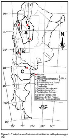
This paper is a preliminary contribution of the REE composition, petrography and microthermometry of fluid inclusions of hydrothermal fluorite veins of the El Portezuelo - Los Mudaderos fluoritic district, northwestern Ancasti range, Sierras Pampeanas, Catamarca province. The veins are located in Sauce Guacho (333.9±10.7 Ma) and Los Mudaderos (369.8±5.3 Ma) granites and in the metamorphic basement (Ancasti Formation). The microthermometric data of fluid inclusions were obtained from granular violet fluorite exfoliation plates from Dal mine, while the REE composition was measured by ICP-OES in fluorite from three different veins. The REE content varies from 6.70 to 64.33 ppm. LREE/HREE > 1, high Lan/Ybn values and distribution patterns indicate enrichment in LREE, suggesting mineralization from early and weakly fractionated hydrothermal fluids. Negative Eu anomaly indicate low oxygen fugacity during fluorite formation. The geochemical data of Tb and La indicate a hydrothermal origin, consistent with the geological and textural-mineralogical features that, in addition, show more than one mineralizing pulse and low formation temperatures. Fluid inclusions vary in size and shape, are predominantly biphasic and show average homogenization temperature of 126 °C. The eutectic was registered between -21 °C and -24 °C and final ice melting was metastable and always ≥0 °C. The veins and host rocks textural features show a shallow emplacement for the fluorite veins.
Eduardo A. Rossello, Gerardo Veroslavsky, Jorge N. Santa Cruz
2 021
Boletín Geológico. Vol. 48 Núm. 1 (2021)
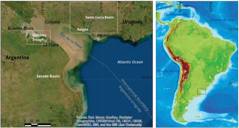
A partir de la propuesta de la fosa tectónica de Quilmes (FQ) como extensión de la prolongación austral de la cuenca Santa Lucía de Uruguay, y su conexión con la cuenca del Salado, de Argentina, se puede considerar como hipótesis de trabajo la existencia de un gran volumen sedimentario, capaz de albergar un nuevo acuífero sobre el litoral rioplatense. Los volúmenes sedimentarios que constituyen la FQ están ocultos debajo de una potente cubierta moderna, por esta razón la falta de estudios de superficie específicos no permite conocer su verdadera naturaleza. Dado que la continuación uruguaya del depocentro meso-cenozoico de la cuenca Santa Lucía está mejor estudiada, a partir de la exploración de hidrocarburos, se pueden estimar características tectosedimentarias equivalentes en la fosa de Quilmes. En el territorio uruguayo se explotan tres sistemas acuíferos que se desarrollan en la cuenca Santa Lucía: el acuífero Raigón (Plio-Pleistoceno), que constituye la fuente de agua subterránea más importante de la región centro-sur de Uruguay, destinada a diversos usos, y los acuíferos cretácicos Mercedes (Cretácico Superior) y Migues (Cretácico Inferior), que también son usados, en menor medida, para el suministro de agua potable, riego y usos industriales. El acuífero Migues es el menos conocido y se desarrolla a profundidades variables (100 a 1500 m), donde exhibe considerables sucesiones de areniscas porosas y permeables que le confieren muy buenas cualidades como roca reservorio, y es objeto de estudio con fines de almacenamiento de gas, recursos geotermales e hídricos. Por esta razón, si las mismas secuencias con cualidades sedimentarias e hidrogeológicas equivalentes están presentes en la fosa de Quilmes, se podría esperar el hallazgo de interesantes acuíferos relacionados, aún desconocidos en el litoral bonaerense, por debajo de los tradicionales Puelches, Pampeano y Paraná. De comprobarse la existencia y calidad de estos recursos hidrogeológicos a partir de la realización de actividades exploratorias específicas, la pendiente-gradiente regional hacia el sudoeste desde los afloramientos de Uruguay, se podrían esperar condiciones de surgencia o semisurgencia natural, e incluso geotermalismo asociado a los acuíferos cretácicos más profundos.
The proposal of the Quilmes Tectonic Trough (Fosa tectónica de Quilmes – FQ) as the extension of the southern end of the Santa Lucía basin in Uruguay and its connection to the Salado basin in Argentina suggest the existence of a large sedimentary volume capable of housing a new aquifer on the La Plata River coast. However, the sedimentary volumes that form the FQ are hidden under a thick, recently deposited cover, and thus, there is a lack of studies on the nature of this formation. Nevertheless, the Uruguayan section of the Meso-Cenozoic depocenter of the Santa Lucía basin has been more thoroughly studied for hydrocarbon exploration, which enabled us to estimate the equivalent tectosedimentary characteristics in the FQ. In the Uruguayan territory, three aquifer systems of the Santa Lucía basin are exploited: the Raigón (Plio-Pleistocene) aquifer, which is the most important source of groundwater for various uses in the south-central region of Uruguay, and the Mercedes (Upper Cretaceous) and Migues (Lower Cretaceous) aquifers, which are also used, albeit to a lesser extent, for drinking water, irrigation, and industrial purposes. The Migues aquifer, the least known of the three, shows a variable depth ranging from 100 to 1500 m and considerable stratigraphic sequences of porous and permeable sandstones. These sandstones provide the aquifer with very good qualities as a reservoir rock; as such, the Migues aquifer has been studied for its potential natural gas reserves and geothermal and water resources. Accordingly, if the same sequences with equivalent sedimentary and hydrogeological qualities are present in the FQ, similar aquifers with interesting properties may remain unidentified along the Buenos Aires coast beneath the intensely explored Puelches, Pampeano and Paraná aquifers. In conclusion, specific exploratory activities may prove the existence and quality of these hydrogeological resources, the regional slope toward the southwest from the Uruguayan outcrops, upwelling or semiupwelling conditions and even geothermal energy associated with the deepest cretaceous aquifers.
Journal of Systematic Palaeontology. Volume 19, 2021 - Issue 2
South American horned frogs (Ceratophryidae), with their large heads, wide gapes and fang-like teeth, are among the most charismatic, best-known and well-studied neobatrachian anurans. The family comprises 12 extant species with hyperossified skulls and has a relatively rich fossil record, particularly in the Pampas, which dates back to the late Miocene. However, several records have been overlooked in recent summaries, and many taxonomic assignments remain indeterminate or are questionable and have yet to be tested within a quantitative phylogenetic framework. Here we provide a complete up-to-date survey of the palaeontological record of Ceratophryidae, including some remarkable new records. We also tested their systematic position through comprehensive phylogenetic analyses based on osteological data, providing several synapomorphies for all relevant nodes. Finally, we discuss these integrated data in relation to divergence time estimates, and propose a set of fossil calibrations that provide hard minimum bounds for crown-group Ceratophryidae and the subclades within it, and illuminate the acquisition of polyploidy within the group.
Revista de la Asociación Geológica Argentina. Vol. 77 No. 4 (2020)
Milka Kronegold de Brodtkorb se graduó en 1957 como Licenciada en Ciencias Naturales (orientación Geología) en la Universidad de Buenos Aires y se doctoró en la misma universidad en 1963. Se especializó en mineralogía y metalogenia con formación de posgrado en Munich y Heidelberg, Alemania. Milka tuvo un activo desempeño profesional en la Comisión Nacional de Energía Atómica, Fabricaciones Militares y la entonces Dirección Nacional de Geología y Minería. Ingresó a la carrera del Investigador Científico del CONICET en 1973 donde fue designada Investigadora Superior en 1999. Dictó numerosos cursos de posgrado sobre mineralogía y paragénesis de menas en varias universidades argentinas y formó gran cantidad de discípulos, especialmente en mineralogía de menas. Sus cerca de 400 publicaciones versaron sobre mineralogía, paragénesis mineral y metalogenia, con obras de síntesis de las cuales fue coautora o editora, entre ellas se destacan los libros Especies Minerales de Argentina. En su larga trayectoria dirigió unos 40 becarios, tesistas, e investigadores. Su itinerario científico fue reconocido a través de varias distinciones, entre otras de la Asociación Geológica Argentina; recibió el premio Strobel de la Universidad de Buenos Aires, fue designada Académica de la Academia Nacional de Ciencias y Doctora Honoris Causa de la Universidad Nacional de Río Cuarto. Palabras clave: mujer, geología, mineralogía, metalogenia.
Maximiliano N. Deri, Patricia L. Ciccioli, Sergio A. Marenssi y William H. Amidon
2 021
Revista de la Asociación Geológica Argentina. Volumen 78(4) Diciembre 2021
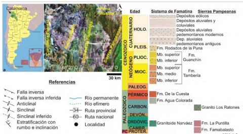
La sucesión neógena del Bolsón de Fiambalá, que aflora en el centro-oeste de la provincia de Catamarca, comprende a las Forma-ciones Tambería, Guanchín y Rodados de la Puna. Sus respectivas edades depositacionales fueron planteadas a partir de datacio-nes U/Pb, trazas de fisión y magnetoestratigrafía, aunque la poca precisión estratigráfica y geográfica de estos datos, sumado a las complejidades estructurales del área, y los 6.4 km de espesor que alcanza la sucesión, tornan necesario esclarecer el ordenamiento estratigráfico de la región, a fines de poder establecer con mayor precisión la evolución de la cuenca. El análisis de las edades disponibles y las de máxima depositación presentadas en este trabajo, arrojan que la Formación Tambería comenzó a depositar-se luego de los ~23 Ma. Esta formación puede separarse en un miembro inferior dominado por areniscas con intercalaciones de conglomerados y pelitas, depositadas en sistemas fluviales multicanalizados de clima semiárido, que gradan a ortoconglomerados polimícticos del miembro medio, acumulados en sistemas fluviales entrelazados. Culmina con un miembro superior constituido por depósitos areno-conglomerádicos y pelíticos, acumulados en sistemas fluviales multicanalizados con planicies areno-pelíticas. La suprayacente Formación Guanchín comenzó a depositarse a los ~6 Ma, y puede separarse en dos miembros: uno inferior compuesto de areniscas con frecuentes intercalaciones de tobas, que se acumularon en diversos sistemas fluviales arenosos; y otro superior areno-conglomerádico resultado de sistemas fluviales entrelazados. Finalmente, en discordancia erosiva se encuentran los depósitos conglomerádicos de abanicos aluviales dominados por flujos mantiformes de la Formación Rodados de la Puna, depositados durante el Pleistoceno (~1.8 Ma).Palabras clave: antepaís fracturado, Formación Tambería, Formación Guanchín, Mio-Plioceno, Andes Centrales.
Stratigraphy of the Neogene succession in Bolson de Fiambalá, Famatina System, Catamarca, Argentina.Bolson de Fiambala Neogene succession crops out in the center-west of Catamarca province. It includes Tambería, Guanchin and Rodados de la Puna formations. Their respective depositional ages were raised from U/Pb dating, fission tracks and magnetostrati-graphy. However, the poor stratigraphic and geographic precision of these data, added to the area ́s structural complexities, and the 6.4 km thick of the succession, makes it necessary to clarify the region ́s stratigraphic ordering to define with more precision the basin evolution. The analysis of available and maximum depositional ages presented in this work, show that Tambería Formation deposition began after ~23 Ma. It can be separated into a lower member, dominated by sandstones with intercalations of conglomerates and shales, deposited in semi-arid multi-channelized fluvial systems. Over these deposits are polymictic conglomerates of the middle Maximiliano N. DERI1,2, Patricia L. CICCIOLI1,2, Sergio A. MARENSSI1,2 y William H. AMIDON31 Universidad de Buenos Aires. Facultad de Ciencias Exactas y Naturales. Departamento de Ciencias Geológicas. Buenos Aires, Argentina2 CONICET – Universidad de Buenos Aires. Instituto de Geociencias Básicas, Aplicadas y Ambientales de Buenos Aires (IGEBA). Buenos Aires, Argentina. 3 Geology Department, Middlebury College, Middlebury, VT, 05753, USA. Emails: maximiliano.deri@gmail.com, ciccioli@gl.fcen.uba.ar, smarenssi@hotmail.com, wamidon@middlebury.edu. Editor: Diego A. KietzmannRecibido: 2 de octubre de 2020Aceptado: 15 de marzo de 2021
Ayudante de Primera en las materias Mineralogía y Petrografía
Petrología, Hidrogeología y Geología planetaria
- Morfología, estratigrafía, petrografía y geoquímica del NE de la Provincia Magmática de Somún Curá
- Análisis de la interacción del agua superficial y el agua subterránea en los tramos superiores y medios de la cuenca del río Reconquista
- Geología, morfología y morfometría del volcán Jezero Mons en Marte
Patricia L. Ciccioli, Norma R. Ratto, Delfina Fernández Molina, Elizabeth Castañeda
2 021
Relaciones de la Sociedad Argentina de Antropología - Vol. 46 Núm. 2 (2021)
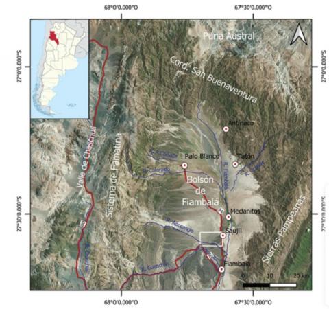
Se presenta un estudio interdisciplinario en la localidad arqueológica de Mishma y su entorno (bolsón de Fiambalá), enfocado en tratar de entender las variaciones ambientales durante el Holoceno tardío. Los objetivos son presentar los principales agentes formadores del paisaje físico y discutir el impacto que tuvo en las poblaciones productivas que habitaron esos espacios y su preservación en el tiempo. Se articula información de relevamientos en terreno, análisis de cartografía satelital e imágenes obtenidas por Drone, datos meteorológicos y el estudio de los depósitos. El análisis permite establecer que durante la ocupación prehispánica las condiciones ambientales eran distintas a las actuales en las cuales el agente eólico es uno de los principales modeladores del paisaje. El siglo XVI se interpreta como el periodo de cambio, previamente, la acción fluvial provocó la incisión del cauce principal del río Apocango relacionada con cambios en el nivel de base de la cuenca.
F. Ibarra, C. B. Prezzi, J. Bott, M. Scheck-Wenderoth, M. R. Strecker
2 021
Journal of Geophysical Research: Solid Earth - Volume126, Issue5 May 2021
We present three-dimensional (3D) models of the present-day steady-state conductive thermal field and strength distribution in the lithosphere beneath the Central Andes. Our primary objective was to investigate the influence that the structure of the Central Andean lithosphere has on its thermal and rheological state, and the relationship between the latter and the active deformation in the region. We used our previous data-driven and gravity-constrained 3D density model as starting point for the calculations. We first assigned lithology-derived thermal and rheological properties to the different divisions of the density model and defined temperature boundary conditions. We then calculated the 3D steady-state conductive thermal field and the maximum differential stresses for both brittle and ductile behaviors. We find that the thickness and composition of the crust are the main factors affecting the modeled thermal field, and consequently also the strength distribution. The orogen is characterized by a thick felsic crust with elevated temperatures and a low integrated strength, whereas the foreland and forearc are underlain by a more mafic and thinner crust with lower temperatures and a higher integrated strength. We find that most of the intraplate deformation coincides spatially with the steepest strength gradients and suggest that the high potential energy of the orogen together with the presence of rheological lateral heterogeneities produce high compressional stresses and strong strain localization along the margins of the orogen. We interpret earthquakes within the modeled ductile field to be related to the weakening effect of long-lived faults and/or the presence of seismic asperities.