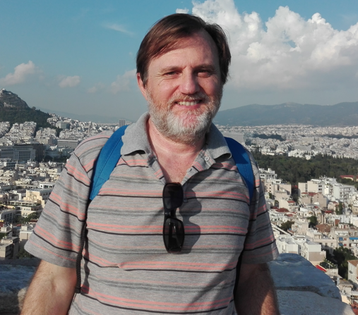
Hallazgos paleoindios en el Rio Negro Medio: nuevos aportes de San Gregorio de Polanco, Uruguay

Hugo Gabriel Nami
2 022
Sociedades e Cultura Material, v. 35 n. 57 (2022)
La colonización y dispersión humana en ambos hemisferios del continente americano es uno de los temas antropológicos y arqueológicos más atractivos del proceso de poblamiento mundial. Estrictamente vinculado con esas investigaciones y la meta de aportar información adicional para ahondar en varios temas de tecno-morfología lítica Paleoindia, se dan a conocer un grupo de artefactos recientemente registrados en la zona de San Gregorio de Polanco, cuenca media del Río Negro, República Oriental del Uruguay. Los mismos posibilitan continuar ampliando la base de datos y profundizar en el conocimiento de diversos aspectos de la distribución de puntas Fell, litos discoidales y artefactos de filos retocados unifaciales correspondientes a los grupos tempranos regionales. Además, las observaciones presentadas permiten discutir las similitudes de esos vestigios con los encontrados en otros lugares de las Américas.
In the world colonization process, the peopling and human dispersion of the Americas is one of the most attractive anthropological and archaeological issues. Strictly linked to these investigations and the goal of providing additional information and delving into various themes of Paleoindian lithic techno-morphology, this paper reports a group of
artifacts recently recorded in the San Gregorio de Polanco area (middle Río Negro basin, Uruguay). They allow expanding the database and deepen our knowledge of various aspects of the distribution of Fell points, discoidal stones, and retouched unifacial edge artifacts corresponding to the early regional groups. In addition, the observations presented serve to discuss the similarities of these remains with those found in other places in the Americas.
Pub-Nami-Hallazgos paleoindios en el

The birth of the Gondwanide arc: Insights into Carboniferous magmatism of the North Patagonian Andes (Argentina)

María Belén Yoya, Sebastián Oriolo, Pablo González, Florencia Restelli, Emiliano Renda, Florencia Bechis, Jerónimo Christie Newbery, Paulo Marcos, Ezequiel Olaizola
2 023
Journal of South American Earth Sciences Volume 123, March 2023
New geological, structural, and geochemical information was obtained for the late Paleozoic basement of the North Patagonian Andes. The studied rocks are mainly formed by foliated diorites and gabbro-diorites with a primitive continental arc signature, according to trace elements patterns. Similar petrological and structural characteristics, together with previously reported ages between ca. 330 and 323 Ma, permit the correlation of these rocks with plutonic bodies located in the North Patagonian Andes, North Patagonian Massif and Cordillera de la Costa of Chile, documenting the onset of Gondwanide subduction along the proto-Pacific margin of Gondwana between ca. 37 and 45°S. Geochemical and geochronological data, together with field evidence, suggest mafic magma replenishment during the construction of this large batholith. The presence of sheeted zones and magmatic fabrics allow to interpret pluton emplacement in a highly coupled system linked with a tectonically active setting, under pressure conditions of ca. 6 ± 1 Kbar.
Pub-Oriolo-The birth of the

The hydrocarbon potential of the offshore Talara Basin, Perú

Eduardo A. Rossello, Stephen P.J. Cossey, Guzmán Fernández
2 022
AndGeo vol.49 no.1 Santiago ene. 2022
La cuenca Talara costa afuera es la extensión occidental de su parte continental que contiene los campos petroleros productores de hidrocarburos desde mediados del siglo XIX en Perú. Esta se encuentra sobre la zona de subducción en el margen activo de los Andes, donde la placa oceánica de Nazca está subduciendo bajo la continental de América del Sur. La porción marina de la cuenca se evaluó utilizando un relevamiento sísmico 3D de alta calidad donde los horizontes de mapeo interpretados son discordancias dentro del Eoceno, así como del Paleoceno superior y el Cretácico Superior. Las posibles rocas generadoras son las lutitas marinas negras del Cretácico de la Formación Redondo (Campaniano), las calizas de la Formación Muerto (Albiano) y las lutitas marinas del Terciario temprano. Se propone que el objetivo principal de la exploración petrolera en alta mar sean las turbiditas de aguas profundas del Paleoceno/Eoceno originadas por aportes desde las tierras altas del noreste, creadas por la elevación compresiva de los Andes. Se considera que los principales sellos en el sector costa afuera sean lutitas de la Formación Lagunitos del Eoceno superior y las lutitas de la Formación Chacra, que también son sellos en el campo terrestre Litoral. El modelo de maduración térmica muestra que existen dos cocinas de hidrocarburos en la parte costa afuera de la cuenca, una en el norte y otra en el sur. La fuente probable del Cretácico alcanzó el inicio de la madurez (VR=0,63%) a una profundidad de 3.250 a 3.285 m (10.663-10.778 pies) entre 30 y 39 Ma (Eoceno tardío al Oligoceno). Es importante destacar que las rocas generadoras del Cretácico permanecen dentro de la ventana de petróleo al ingresar en el Eoceno tardío. Los estudios satelitales muestran una gran emanación actual de petróleo en alta mar, en la parte sur de la cuenca y la sísmica 3D presenta indicadores directos de hidrocarburos (DHI) en imágenes como puntos planos y reflectores de simulación de fondo (BSR). El modelado de cuencas sugiere que las vías de migración de los hidrocarburos habrían sido ascendentes hacia el este, en dirección a las trampas en tierra y, por lo tanto, habrían llenado primero las trampas en alta mar a lo largo de la vía de migración. Se concluye que la cuenca Talara costa afuera ofrece excelentes oportunidades de exploración en un área productiva probada donde se han identificado múltiples prospectos.
The offshore Talara Basin is the western extension of the hydrocarbon producing onshore fields since the mid-1800s area of Peru and is also located above the subduction zone of the active continental margin of South America. The offshore portion was evaluated using high quality 3D seismic where mapping horizons are all unconformities within the Eocene as well as the unconformities at the top Paleocene and top Cretaceous. Possible source rocks are the Cretaceous black marine shales of the Campanian Redondo Formation, the limestones of the Albian Muerto Formation, and the marine shales of the Paleogene. The primary target offshore is expected to be deep-water turbidites of Paleocene/Eocene age with a depositional source from the northeast from highlands created by the compressional uplift of the Andes. The main seals offshore are expected to be shales of the upper Eocene Lagunitos Formation and shales in the Chacra Formation, which are also seals in the onshore Litoral field. Thermal maturation modeling shows that two hydrocarbon kitchens exist in the offshore portion of the Talara basin, one in the north and another in the south. The probable Cretaceous source rocks reached the onset of maturity (VR=0.63%) at a depth of 3,250 to 3,285 m (10,663-10,778 ft) between 30 and 39 Ma (Late Eocene to Oligocene). Importantly, the Cretaceous source rocks stay within the oil window once they enter it in the late Eocene. Satellite studies show a large offshore present-day oil seep in the southern part of the basin and 3D seismic shows direct hydrocarbon indicators (DHIs) imaged as flat spots and bottom simulating reflectors (BSR). Basin modeling suggests hydrocarbon migration pathways would have been updip (to the east) into the onshore traps and would therefore have first filled the offshore traps along the migration pathway. We conclude that the Talara Basin offshore offers excellent exploration opportunities in a proven productive area where multiple prospects have been mapped.
Pub-Rossello-The hydrocarbon potential of

Reconstructing paleoenvironmental and diagenetic dynamics from clay mineral assemblages in the Neogene Fiambalá Basin, NW Argentina

Virginia Valeria Reinoso Carbonell, Gilda Collo, Cecilia A. Wunderlin, Pablo H. Alasino, Patricia L. Ciccioli, Sebastian Rocher, Santiago Maza
2 022
Social Science Research Network, 06/2022, 24pp
Clay mineral characterization is a valuable tool for unraveling the evolution of continental sedimentary basins. The Fiambalá basin is a foreland basin located in the Southwest of the province of Catamarca (Argentina), on the flat subduction zone of the Nazca Plate below the South American. In order to characterize its paleoenvironment and post-depositional evolution, we carried out petrographic, X-ray diffraction (XRD) and scanning microscopy (SEM-EDS) studies in detrital and volcaniclastic samples from the Tambería, Guanchín and Rodados de la Puna Fms. Petrographic and XRD analyzes show a predominance of phyllosilicates, quartz, plagioclase, low proportions of feldspar and anhydrite, sporadic calcite, analcime, heulandite and hematite. In the fraction < 2 microns, minerals from the smectite and illite groups dominate, with lower proportions of chlorite and kaolinite. An analyzed tuff level only presents smectite in this fraction. The textural-compositional analyzes of SEM-EDS show that illite and chlorite have a detrital origin and their preservation would be consistent with the dominance of an arid climate in the region during the erosion and deposition of material from the source areas. The smectites are of the magnesium-rich beidellite-montmorillonite type and, together with the zeolites would be authigenic generated as a product of the alteration of the volcanic material and magnesian detrital phases (chlorite and biotite), possibly under the influence of an alkaline environment related to the arid climate. From a thermal point of view, the presence of smectite throughout all stratigraphic succession allows interpreting maximum temperatures that, even in the deepest levels of the basin, inhibit the development of prograde phases (such as smectite/illite and smectite/chlorite mixed-layered) and allow the preservation of smectite. Paleogeothermal gradients of between 13 and 18 °C/km and between 8 and 11 °C/km, could be estimated considering thicknesses of ca. 4000 m and ca. 6400 m, respectively.
Pub-Ciccioli-Reconstructing paleoenvironmental and diagenetic

¿Qué edad tiene el Núcleo Interno de la Tierra?

Augusto E. Rapalini
2 022
Temas De Biología Y Geología Del NOA, Vol. 12 Núm. 2 (2022)
La sismóloga danesa Inge Lehmann (Figura 1) descubrió en 1936 la existencia del Núcleo Interno (NI) de nuestro planeta (Lehmann, 1936). Tras casi 90 años de investigaciones, principalmente pero no únicamente, sismológicas, es mucho lo que se ha avanzado en el conocimiento del fragmento más recóndito del interior de la Tierra. A pesar de ello, lo que sabemos del NI es aún muy esquemático, preliminar y en muchos casos hipotético. Como sabemos desde la escuela primaria, el interior de la Tierra se divide, en base a su composición química, en Corteza (que puede ser continental u oceánica), Manto y Núcleo (Figura 2). Esta división fue descubierta por los pioneros de la Sismología a principios del siglo XX. Mientras que la Corteza tiene espesores que van desde cerca de los 70 km, en algunas grandes cadenas montañosas, hasta literalmente cero, en las cordilleras centro-oceánicas (o dorsales), el Manto se extiende hasta los 2900 km de profundidad…
Pub-Rapalini-Que edad tiene el

Caracterización de estructuras del manto superior en la región del extremo norte de la Península Antártica, mediante un análisis de las anomalías de velocidad sísmica

Zambrano, Oscar Marcos; Gulisano, Adriana Maria; Poma, Stella Maris; Ruocco, María Inés
2 022
Revista de la Asociación Geológica Argentina Volumen 79 (3) 03-2022
Se realizó una tomografía sísmica de inversión conjunta basada en los residuales de tiempo de viaje de las ondas P y S, con el objeto de estudiar la estructura sísmica del manto superior infrayacente a la dorsal Sur del Scotia y extremo norte de la Península Antártica. La misma se basó en registros sismográficos adquiridos en forma continua en estaciones sismológicas situadas en bases antárticas argentinas, procedentes del Proyecto Argentino Italiano para la gestión y mantenimiento de la red ASAIN: Antarctic Seismograph Argentinian ItalianNetwork. Las señales analizadas corresponden a eventos sismotectónicos locales de moderada a elevada mag-nitud ocurridos entre los años 2009 y 2019. Para la inversión discreta de los datos se implementó el método de regularización. Los resultados fueron evaluados mediante pruebas de resolución sintéticas. Se caracterizaron e interpretaron las estructuras sísmicas resueltas en las tomografías. El estudio se complementó mediante la estimación del módulo de Poisson y de la anomalía de velocidad acústica Vφ, lo cual permitió incorporar condiciones de restricción y por tanto de valoración a la interpretación de las tomografías. Se destaca la presencia de una anomalía negativa de velocidad de onda S en el sector de la cuenca Bransfield, en correspondencia con lo reportado por otros autores. Se interpreta como una región de la corteza y manto sometida a modificaciones del estado reológico (disminución de la rigidez, incremento de la incompresibilidad y aumento de la anelasticidad) causadas por un flujo térmico anómalo proveniente de una fuente localizada a mayor profundidad en el manto.
Characterization of upper mantle structures in the northern region of the Antarctic Peninsula, through an analysis of seismic velocity anomalies.
In order to study the seismic structure of the upper mantle underlying the South ridge of Scotia and the northern end of the Antarctic Peninsula, a joint inversion seismic tomography, based on the travel time residuals of the P and S waves, was carried out. It was based on seismographic records acquired continuously at seismological stations located in Argentine Antarctic bases, from the Argentine-Ita-lian Project for the management and maintenance of ASAIN: Antarctic Seismograph Argentinian Italian Network. The signals used correspond to local seismotectonic events of moderate to large magnitude that occurred between 2009 and 2019. The regularization method was implemented for the data discrete inversion. The results were evaluated by synthetic resolution tests. The seismic structures resolved with the tomographies were characterized and interpreted. The study was complemented by estimating the Poisson's modulus and the bulk sound velocity anomaly, which allowed the incorporation of restriction conditions and, therefore, assessment conditions in the interpretation of the tomographies. The presence of a negative S-wave velocity anomaly in the Bransfield basin sector is highlighted, in correspondence with that reported by other authors. It is interpreted as a region of the crust and mantle subjected to modifications of the rheological condition (decrease in rigidity, increase in incompressibility and increase in anelasticity) caused by an anomalous thermal flux from a source located deeper in the mantle.
Pub-Poma-Caracterización de estructuras del

Compositional, thermal, and tectonic contributions to the present-day elevation of the Central Andes and their forearc and foreland regions

Claudia Beatriz Prezzi, Federico Ibarra
2 022
Revista de la Asociación Geológica Argentina, Vol. 79 No. 1 (2022)
Los Andes Centrales están caracterizados por una serie de unidades morfoestructurales que presentan rasgos estratigráficos, es-tructurales y geomorfológicos distintivos. Destacan a simple vista las marcadas variaciones topográficas transversales al orógeno. Estudios teóricos sobre la elevación de los continentes han discretizado distintas componentes que contribuyen a la elevación obser-vada, prevaleciendo las contribuciones composicional y térmica. Investigaciones previas han demostrado que la región presenta una alta variabilidad en su composición cortical y estado termal. Estas variaciones podrían ejercer un control en la topografía regional, como ya ha sido señalado en un estudio previo del plateau Altiplano-Puna. En esta línea, este trabajo se propone investigar la re-lación entre la elevación actual de los Andes Centrales, su composición cortical y estado térmico. La contribución térmica esperada para cada unidad morfoestructural fue calculada en base al desarrollo de modelos térmicos 1D construidos utilizando datos de flujo térmico superficial. Con el objetivo de remover la contribución composicional de la corteza a la elevación observada, se calculó una elevación normalizada. Dicha elevación fue comparada con la contribución térmica estimada para evaluar su ajuste en cada unidad morfoestructural. El plateau Altiplano-Puna y la Cordillera Occidental muestran una buena correlación, sugiriendo que la composición y temperatura controlan su elevación actual. Por el contrario, en los otros sectores se observa un desajuste. El análisis detallado de cada unidad sugiere que los procesos tectónicos de subducción, las contribuciones del manto y los estados transitorios (i.e. no es-tacionarios, en desequilibrio) deben ser también considerados como contribuciones importantes al estado térmico y/o a la elevación actual.
The Central Andes of South America are characterized by different morphotectonic units that exhibit distinctive stratigraphic, structural, and geomorphic features. In particular, the topographic variations across the orogen are remarkably notorious. Theoretical studies on the elevation of continents have discretized distinct components that contribute to the observed elevation, among which the compositional and thermal contributions prevail. Previous investigations in the Central Andes have shown that the region presents a high variability in its crustal composition and thermal state. Such variations could exert a first-order control on the regional topography, as shown previously for the Altiplano-Puna plateau area. This study, therefore, sets out to investigate the relationship between the present-day elevation of the Central Andes, its crustal composition, and its thermal state. We first calculated the predicted thermal contribution for each morphotectonic unit based on 1D geotherms modeled on the basis of surface heat-flow data. In order to remove the compositional contribution of the crust, we then calculated a normalized elevation. This elevation was compared to the predicted thermal contribution to evaluate their fit in each morphotectonic unit. The Altiplano-Puna plateau and the Western Cordillera exhibit a good correlation, suggesting that composition and temperature control their present-day elevation. Conversely, the other areas show a significant misfit. The detailed analysis of the remaining morphotectonic units suggests that tectonic processes at the subduction zone, mantle contributions, and transient states need to be considered as important contributors to the present-day thermal state and/or elevation.
Pub-Prezzi-Compositional thermal and tectonic

Misterios y rarezas del final del precámbrico: un enfoque paleomagnético

Augusto E. Rapalini
2 022
GEOACTA VOL. ESPECIAL 43(2):30-45(2022)
El Ediacarano (o Ediacárico) es el período terminal del Precámbrico, extendiéndose desde los 635 hasta los 541 millones de años (Ma). Durante ese lapso el planeta parece haber experimentado una serie de eventos y procesos extraordinariamente singulares, cuya real existencia y características detalladas son motivo de numerosos debates y controversias. Algunos de los acontecimientos que con mayor o menor certeza se investigan, discuten y analizan en la actualidad son: 1) la aparición de la primera biota compleja de organismos multicelulares de la historia de la Tierra pero que no dejaría sucesores en el Fanerozoico; 2) la mayor excursión isotópica de δ13C de la historia del planeta (excursión Shuram) y su relación con la evolución de los océanos; 3) la existencia de una glaciación que alcanzó bajas latitudes (glaciación Gaskiers) y sus impactos paleoambientales globales; 4) La cronología y cinemática de la ruptura final del supercontinente Rodinia y de la subsecuente formación del Gondwana; 5) la existencia de desplazamientos polares verdaderos muy
veloces y de cerca de 90° por intercambio de los ejes de inercia del planeta; 6) la posibilidad de que los polos magnéticos estuvieran ubicados durante largos lapsos en el ecuador; 7) un campo magnético ultradébil, con la menor paleointensidad registrada; 8) un campo magnético hiperactivo, con la máxima frecuencia de reversiones de polaridad conocida; 9) el posible inicio de la formación del núcleo interno y el subsecuente cambio en la modalidad de la geodínamo terrestre; entre varios más. A través de estudios paleomagnéticos sistemáticos es posible aportar información muy valiosa para resolver
muchos de estos interrogantes. Desde hace dos décadas, en el Laboratorio de Paleomagnetismo Daniel A. Valencio del IGEBA venimos desarrollando estudios multidisciplinarios sistemáticos en rocas sedimentarias y volcánicas ediacaranas del cratón del Río de la Plata. Estas investigaciones se nutren de una colaboración estrecha y continua con colegas de otros grupos de investigación de Argentina, Brasil y Uruguay. Los estudios incluyen principalmente investigaciones paleomagnéticas con el fin de reconstruir la evolución paleogeográfica del cratón en el Ediacarano y aportar a conocer la cinemática de la formación del Gondwana. Recientemente estamos también avanzando en el conocimiento de las reversiones de polaridad del paleocampo magnético en el Ediacarano tardío. Dataciones geocronológicas precisas, estudios isotópicos sistemáticos y recientes hallazgos fósiles espectaculares, sumados a la información paleomagnética, están aumentando significativamente nuestro conocimiento de un período hasta hace dos décadas casi desconocido. Estos avances incluyen una reconstrucción esquemática de la evolución paleogeográfica del cratón del Río de la Plata entre aproximadamente 600 y 550 Ma, durante el cual el mismo habría migrado desde bajas a altas latitudes. Con esta información y la de otros cratones de Gondwana Occidental están surgiendo restricciones a las edades de anexión con Congo-São Francisco y África Occidental. También permiten especular con mayor sustento observacional sobre la posible existencia (o no) de un gran océano llamado Clymene en etapas finales de formación del Gondwana. El probable registro de la excursión Shuram en sedimentos calcáreos del cratón es una posibilidad concreta a medida que avanzan los estudios quimioestratigráficos. Si bien aún de modo incipiente, los primeros resultados magnetoestratigráficos que estamos obteniendo sugieren la aparente presencia de rápidas reversiones de polaridad. Esta sucesión de nuevos resultados marca límites a ciertos modelos o propuestas no actualistas mientras que es compatible con otros, abriendo un importante número de nuevos interrogantes. En este trabajo se presenta un breve resumen del conocimiento actual a nivel global de muchas de estas controversias, así como del avance de las investigaciones en nuestro país.
Ediacaran (or Ediacaran) is the terminal period of the Precambrian, extending from 635 to 541 million years ago (Ma). During this period the planet appears to have experienced a series of extraordinarily singular events and processes, whose actual existence and detailed characteristics are the subject of much debate and controversy. Some of the events that are more or less certainly investigated, discussed and analyzed at present are: 1) the appearance of the first complex biota of multicellular organisms in Earth's history but which would leave no successors in the Phanerozoic; 2) the largest δ13C isotopic excursion in the history of the planet (Shuram excursion) and its relationship with the evolution of the oceans; 3) the existence of a glaciation that reached low latitudes (Gaskiers glaciation) and its global paleoenvironmental impacts; 4) the chronology and kinematics of the final rupture of the supercontinent Rodinia and the subsequent formation of Gondwana; 5) the possibility of very fast true polar displacements of about 90° by exchange of the inertial axes of the planet; 6) the possibility that the magnetic poles were located for long periods at the equator; 7) an ultraweak magnetic field, with the lowest paleointensity on record; 8) a hyperactive magnetic field, with the maximum frequency of known polarity reversions; 9) the possible beginning of the formation of the Internal nucleus and the subsequent change in the mode of the terrestrial geodynamo; and many more. Through systematic paleomagnetic studies it is possible to provide valuable information to resolve many of these questions. For two decades, in the Daniel A. Valencio Paleomagnetism Laboratory of the IGEBA we have been developing systematic multidisciplinary studies in sedimentary and volcanic Ediacaran rocks of the Río de la Plata craton. These investigations are nurtured by a close and continuous collaboration with colleagues from other research groups in Argentina, Brazil and Uruguay. The studies include mainly paleomagnetic investigations in order to reconstruct the paleogeographic evolution of the Ediacaran craton and to contribute to understand the kinematics of the formation of Gondwana. Recently we are also advancing in the knowledge of the polarity reversions of the magnetic paleofield in the late Ediacaran. Accurate geochronological dating, systematic isotopic studies and recent spectacular fossil finds, in addition to paleomagnetic information, are significantly increasing our knowledge of a period that until two decades ago was almost unknown. These advances include a schematic reconstruction of the paleogeographic evolution of the La Plata River craton between approximately 600 and 550 Ma, during which time it would have migrated from low to high latitudes. With this information and that of other West Gondwana cratons, constraints on the ages of annexation with Congo-São Francisco and West Africa are emerging. They also allow speculation with more observational support on the possible existence (or not) of a big ocean called Clymene in late stages of Gondwana formation. The probable record of the Shuram excursion in calcareous sediments of the craton is a concrete possibility as chemostratigraphic studies progress. Although still incipient, the first magnetostratigraphic resultswe are obtaining suggest the apparent presence of rapid polarity reversions. This succession of new results marks limits to certain models or non-current proposals while it is compatible with others, opening an important number of new questions. In this paper we present a brief summary of the current global knowledge of many of these controversies, as well as the progress of research in our country.
Pub-Rapalini-Misterios y rarezas del final

Deformation understanding in the Upper Paleozoic of Ventana Ranges at Southwest Gondwana Boundary

Guadalupe Arzadún, Renata Nela Tomezzoli, Natalia Fortunatti, Nora Noemi Cesaretti, María Belén Febbo & Juan Martin Calvagno
2 021
Scientific Reports volume 11 (2021)
At the east of the Ventana Ranges, Buenos Aires, Argentina, outcrops the Carboniferous-Permian Pillahuincó Group (Sauce Grande, Piedra Azul, Bonete and Tunas Formation). We carried out an Anisotropy of Magnetic Susceptibility (AMS) study on Sauce Grande, Piedra Azul and Bonete Formation that displays ellipsoids with constant Kmax axes trending NW–SE, parallel to the fold axes. The Kmin axes are orientated in the NE–SW quadrants, oscillating from horizontal (base of the sequence-western) to vertical (top of the sequence-eastern) positions, showing a change from tectonic to almost sedimentary fabric. This is in concordance with the type and direction of foliation measured in petrographic thin sections which is continuous and penetrative to the base and spaced and less developed to the top. We integrated this study with previous Tunas Formation results (Permian). Similar changes in the AMS pattern (tectonic to sedimentary fabric), as well as other characteristics such as the paleo-environmental and sharp curvature in the apparent polar wander path of Gondwana, marks a new threshold in the evolution of the basin. Those changes along the Pillahuincó deposition indicate two different spasm in the tectonic deformation that according to the ages of the rocks are 300–290 Ma (Sauce Grande to Bonete Formation deposition) and 290–276 Ma (Tunas Formation deposition). This Carboniferous-Permian deformation is locally assigned to the San Rafael (Hercinian) orogenic phase, interpreted as the result of rearrangements of the microplates that collided previously with Gondwana, and latitudinal movements of Gondwana toward north and Laurentia toward south to reach the Triassic Pangea.
Pub-Tomezzoli-Deformation understanding in the