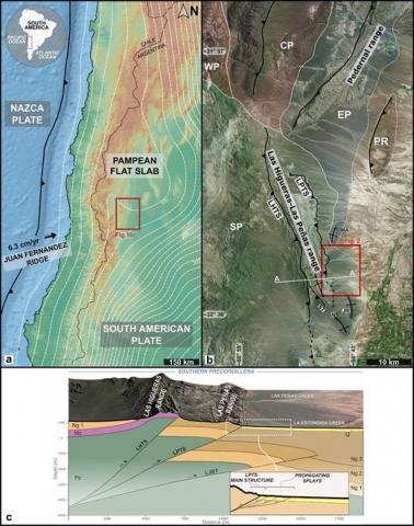
At the southern Pampean flat-slab of the Central Andes, Quaternary-active deformation is concentrated at the easternmost thrusts of the Southern Precordillera along the Las Higueras-Las Peñas range (32° 10′-32° 45′S). This range is bounded by the Las Peñas Thrust System (LPTS), which emplaces Cenozoic sedimentary rocks over a suite of Quaternary alluvial deposits under variable shortening rates. This study focuses on the southern part of this range (La Escondida Creek). Here, the east-verging Quaternary-active thrust front has been shifting toward the piedmont area since Pliocene-Pleistocene times, through discrete splays that bound four different morphotectonic domains. To unravel the shortening related to these propagating thrust splays, we applied trishear forward modeling and retrodeformation of geometric markers such as folded and faulted stratigraphic layers and well-preserved alluvial surfaces, supported by detailed topographic surveys. We compare shortening estimations derived from trishear forward models of deformed layers in a propagating thrust exposure with the data obtained from modeling the resulting thrust scarp morphology on an alluvial surface. Shortening rate assessments for the most recent footwall-propagating thrust yielded scattered values; however, the most reliable estimate is likely below 1 mm/a for this Quaternary frontal thrust.
María Duperron, Dominique Mouazé, Pierre Weill, Bernadette Tessier, Roberto Adrián Scasso
2 025
Sedimentology, Volume72, Issue4 June 2025 Pages 1343-1368
Bioclastic phosphorites composed of linguliform brachiopod shell debris remain largely unexplored from a sedimentological, process-oriented perspective. Understanding the hydrodynamic behaviour of these low-density, platy sediments is essential for elucidating the concentration mechanisms driving their accumulation. The present experimental study delves into this issue through the determination of settling velocity and critical shear velocity of organo-phosphatic bioclasts derived from extant Lingula anatina shells (Brachiopoda: Linguliformea). A total of 137 settling velocity determinations were obtained through stroboscopic photography of the particles' trajectories in a settling tube. In all, 30 critical shear velocity determinations of five sieve fractions were acquired from flow profiles measured in flume experiments. Additionally, L. anatina shell density is here reported for the first time. Organo-phosphatic bioclasts present low particle densities (1040 to 1734 kg/m3), which combined with their platy shape grant them low settling velocities and critical shear velocities comparable to siliciclastic sediments. They thus present a tendency to be easily transported once set in motion coupled with significant resistance to erosion, defining a dual hydrodynamic behaviour like the one reported in platy carbonate sediments. Their resistance to erosion, despite their relatively low submerged weight, is here hypothesized to be explained by shape effects such as elevated intergranular friction forces, large pivoting angles and a low degree of exposure to the flow. In terms of settling, gravel-sized organo-phosphatic bioclasts are equivalent to fine-to-coarse-sized siliciclastic sand; this reflects the textural characteristics of many ancient phosphorite deposits, suggesting that settling equivalence played a role in their deposition and that the common conception of phosphatic particles as a heavy, relatively immobile component is not readily applicable to organo-phosphatic bioclasts. These results shed light on the sedimentology of ancient bioclastic phosphorites and contribute to the still underexplored field of biogenic sediment transport.
María Emilia Bravo, Lisa A. Levin, Viviana Alder, Graziella Bozzano, Alejandro D. Buren, Juan Cruz Carbajal, Paola Davila, Brenda L. Doti, Federico D. Esteban, Pedro Flombaum, Diego A. Giberto, Juliana Giménez, Micaela Giorgini, Valeria A. Guinder, Federico M. Ibarbalz, Lucía C. Kahl, María Eugenia Lattuca, Daniel Lauretta, Gustavo A. Lovrich, Mariano I. Martínez, Adriana Menoret, Guido Pastorino, Martha P. Rincón-Díaz, Laura A. Ruiz-Etcheverry, Sebastián E. Sabatini, Ricardo Sahade, Ornella Silvestri, Marcos Tatián, Valeria Teso, Diego G. Urteaga, Eleonora Verón, Sandra M. Vivequin, Chih Lin Wei
2 025
Marine and Fishery Sciences (MAFIS), Vol. 38 Núm. 4 (2025)
Los ecosistemas del mar profundo argentino y su biodiversidad son sensibles a los efectos de la variación climática como el calentamiento, la pérdida de oxígeno y la acidificación oceánica. Esta vulnerabilidad se debe a características particulares como la presencia de especies longevas, con tasas de crecimiento y de reproducción muy lentas, que dependen de hábitats de configuraciones complejas. Como consecuencia, muchos ecosistemas del mar profundo afectados por perturbaciones tienen baja probabilidad de recuperarse, y si lo hicieran, requerirían cientos o miles de años. Este trabajo sintetiza los resultados de un Taller de Especialistas que permitió revisar el estado actual de conocimiento científico y de su aplicación a la gestión del mar profundo argentino, desde un enfoque ecosistémico que contemple la variación climática. El mar profundo de la Argentina abarca profundidades de entre 200 y 6.000 m, lo que representa más del 70% del territorio marítimo nacional, con una superficie aproximada de 4,6 millones de km2. En el fondo marino argentino, la complejidad geomorfológica y oceanográfica indica un alto potencial para sostener una enorme biodiversidad asociada al fondo. Sin embargo, el conocimiento sobre sus ecosistemas y las políticas de gestión ambiental de este vasto territorio argentino han sido limitados y fragmentados, especialmente en lo que respecta a la incorporación de la variable climática. Diseñar políticas efectivas que protejan su biodiversidad y los múltiples beneficios que aporta a la sociedad implica: i) un asesoramiento técnico robusto, para lo cual, es esencial fortalecer el conocimiento científico sobre los ecosistemas del mar profundo argentino y su interacción con la variación climática; y ii) una articulación y colaboración sostenida entre todos los sectores involucrados.
Gravitation and Cosmology, Volume 30, pages 172–188
A first introduction is presented to the comparison between classical and relativistic gravitational effects related to planetary shape characterization. The Earth and the giant planets are the examples considered. The analysis is mainly devoted to relativistic and classical predictions of periastron shifts for equatorial or almost equatorial orbits around the Earth and the giant planets, which can be used as tools for determinations of the shape and density distribution. The ratios between relativistic (up to the Lense–Thirring order correction) and classical (resulting from the harmonic expansion) effects and their dependence on the orbit parameters are analyzed in order to identify the conditions improving the possibility to resolve mixed effects. In a complementary approach, predictions for freely falling test particles from relativistic corrections and classical harmonic expansions of the Earth and other planets are compared within the same shape characterization framework.
Martin Mantilla, Cristian Salazar, Eduardo Rossello
2 024
Geosciences, v. 43 n. 4
O Alto La Hocha High (LHH), na Bacia do Alto Magdalena da Colômbia, consiste em um embasamento cristalino recoberto por uma sequência sedimentar do Triássico ao Neogeno de até 9 km de espessura. A Falha de San Jacinto (SJF) é uma estrutura de flor positiva dextral NE-SW com cisalhamento de Riedel subordinado que atinge N-S com mergulho subvertical a alto para o oeste. Ela separa dois domínios estruturais principais: (i) o LHH e o sinclinal Tesalia no bloco de parede suspensa ocidental; e (ii) um bloco de parede de pé oriental com um sinclinório com três anticlinais en echelon de tendência norte-sul (mostra um anticlinal reclinado, apertado, em forma de Z mergulhando entre 45 e 90° para o oeste), definindo os campos de petróleo La Cañada e La Cañada Norte. O LHH passou por pelo menos cinco pulsos de transpressão entre o Maastrichtiano e o presente. Variações da orientação da direção resultaram em segmentos flexurais locais que são mais transtensivos para a direita e transpressivos para a esquerda. Interpretações estruturais anteriores baseadas em seções balanceadas 2D sugeriram empilhamento de escamas de empurrão destacadas na base como resultado da convergência de placas ortogonais. No entanto, esta nova interpretação 3D, baseada em geologia de superfície, dados de poços e uma recente pesquisa sísmica 3D, mostra evidências claras de componentes andinos destrais de empurrão em falhas normais preexistentes que controlaram o rifteamento do Triássico-Jurássico.
The La Hocha High (LHH), in the Upper Magdalena Basin of Colombia, consists of a crystalline basement overlain by a Triassic to Neogene sedimentary sequence up to 9 km thick. The San Jacinto Fault (SJF), is a dextral NE-SW striking positive-flower structure with subordinate Riedel shears which strikes N-S with subvertical to high dip to the west. It separates two main structural domains: (i) the La LHH and the Tesalia syncline in the western hanging wall block; and (ii) an eastern footwall block with a synclinorium with three north-south trending en echelon anticlines (shows a recumbent, tight, Z-shaped anticline dipping between 45 and 90° to the west), La Cañada and La Cañada Norte oil fields. The LHH has undergone at least five pulses of transpression between the Maastrichtian and present. Variations of the strike orientation have resulted in local flexural segments that are more transtensive to the right and transpressive to the left. Previous structural interpretations based on 2D balanced sections suggested stacking of thrust sheets detached in the basement as a result of orthogonal plate convergence. However, this new 3D interpretation, based on surface geology, well data and a recent 3D seismic survey, shows clear evidence of dextral Andean thrust components on pre-existing normal faults that controlled Triassic-Jurassic rifting.
Eduardo A. Rossello, Oscar R. López-Gamundí, Marcos E. Mozetic
2 023
Boletín de Geología, Vol. 45 Núm. 3 (2023)
El Bloque Oritupano-Leona (BOL) está localizado en la prolífera Subcuenca de Maturín perteneciente a la Cuenca Oriental de Venezuela en el flanco sur de la plataforma de antepaís cercana al Río Orinoco. A partir de la interpretación sísmica disponible, se reconoce un modelo estructural 3D relacionado sintectónicamente con la secuencia del Mioceno Inferior-Plioceno a partir de tres sistemas de fallas de crecimiento formadas por segmentos subordinados en el Mioceno Inferior (17,3 Ma), Mioceno Medio (15,35 Ma) y Mioceno Superior-Plioceno. El estilo estructural exhibe fallas normales de rumbo E-O inclinadas al Norte (fallamiento sintético) o al Sur en contrapendiente regional (fallamiento antitético) conformando pilares tectónicos y pliegues de arrastre asociados afectados por fallas transpresivas dextrales de rumbo NE-SO inclinadas al NO con extremos solapados por propagación lateral y vertical. Los fallamientos generan ambientes propicios para el acomodamiento de volúmenes sinsedimentarios con potencias variables entre los tramos intermedios y centrales de los segmentos de fallas que contienen los principales entrampamientos de los niveles de las formaciones Oficina y Merecure, responsables de los recursos hidrocarburíferos del BOL. Las morfologías estructurales se vinculan con un escenario transtensivo dextral relacionado con un levantamiento flexural durante los tiempos Oligoceno-Mioceno por la traslación oriental de la placa Caribe a lo largo del límite septentrional de la placa Sudamérica. El presente análisis aporta criterios estructurales que contribuyen con la definición de estrategias para la exploración y desarrollo de objetivos exploratorios remanentes.
The Oritupano-Leona Block (BOL) is located along the southern margin of the prolific Maturín Sub-Basin (Eastern Basin of Venezuela). From the available seismic interpretation, a 3D structural model for the Lower Miocene-Pliocene sequence is proposed based on three growth fault systems formed by subordinate segments in the Lower Miocene (17.3 Ma), Middle Miocene (15.35 Ma), and Late Miocene-Pliocene. The structural style is characterized by E-W synthetic normal faults dipping to the North or to the South in a regional counterslope (antithetic faulting) forming tectonic pillars and associated drag folds affected by NE-SW oriented, dextral transpressive faults dipping to the NW with overlapping ends due to lateral and vertical propagation. The faults generated the accommodation for growth strata synsedimentary with variable strengths between the intermediate and central sections of the fault segments, where traps were formed for the sandstones of the Oficina and Merecure formations. The structural morphologies are linked to a dextral transtensive system related to a flexural uplift during Oligocene-Miocene times due to the eastern translation of the Caribbean plate along the northern limit of the South American plate. This analysis provides structural criteria that contribute to the definition of strategies for exploration and development of remaining exploratory targets.
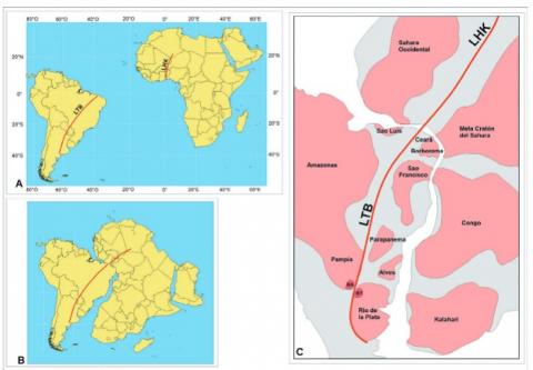
Las principales características sismológicas de la región Chacopampeana permiten diferenciar un clúster de sismos someros de baja intensidad vinculados a una reactivación transpresional intracortical del Lineamiento Transbrasiliano (LTB), y otro clúster de sismos muy profundos y mayor intensidad dispuestos submeridianalmente en las provincias de Santiago del Estero, Chaco y Formosa asociados con las expresiones más distales de la subducción de la placa de Nazca. La coincidencia espacial del reciente terremoto del 31 mayo del 2022 a las 0:57:06 (UTC) con epicentro a 10 km en 24.761°S 58.211°W, con la traza del LTB sugiere su vinculación al facilitar la liberación de energía a partir de antiguos fallamientos tectónicos limitantes de bloques basamentales por una reactivación andina. El Lineamiento Transbrasiliano es una zona de sutura transcontinental de primer orden durante la consolidación del Gondwana Occidental previo a la apertura Atlántica, limitante de ambientes cratónicos de Brasil, Argentina y Paraguay y, en su continuación africana, bloques cratónicos de Benín, Togo y Argelia. En la región chacopampeana de Paraguay y Argentina se asocia con la convergencia transpresional dextral cratónica de los bloques Rodinia y Rio de la Plata donde la extensa cubierta sedimentaria meso-cenozoica impide su expresión en superficie. Sin embargo, es posible interpretarlo en el subsuelo a partir de los escasos relevamientos geofísicos disponibles (relevamientos 2D de reflexión sísmica, magnetotelúricos y gravimétricos).
The main seismological characteristics of the Chacopampean region allow the identification of 2 different earthquake clusters: a) a shallow one of low intensity, linked to the Transbrazilian Lineament (LTB) by its intracor-tical transpressional reactivation, and b) another very deep one of higher intensity, located submeridionally in the provinces of Santiago del Estero, Chaco and Formosa, linked to the most distal expressions of the subduc-tion of the Nazca Plate. The spatial coincidence of the recent earthquake of May 31, 2022 at 0:57:06 (UTC) with hipocenter at 10 km (24.761°S and 58.211°W), with the trace of the LTB suggests its linkage by facilitating the release of energy by Andean tectonic faulting reactivation. The TL is a first-order transcontinental suture zone during the consolidation of Western Gondwana prior to the opening of the Atlantic Ocean. It is the boundary of the cratonic environments of Brazil, Argentina and Paraguay and, in its African continuation, the cratonic blocks of Benin, Togo and Algeria. In the Chacopampean region of Paraguay and Argentina, it is associated with the cratonic dextral transpressional convergence of the Rodinia and Rio de la Plata blocks, where the extensive Meso-Cenozoic sedimentary cover prevents its surface expression. However, it can be interpreted in the subsurface from the few exploration wells and geophysical surveys available (2D seismic reflection, magnetotelluric and gravimetric surveys).
Latin American Journal of Sedimentology and Basin Analysis 31(2):162-187, December 2024
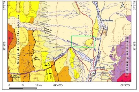
El presente trabajo se enfoca en la caracterización morfológica, textural y composicional de ciertas geoformas lineales reconocidas en el oeste y centro del Bolsón de Fiambalá, oeste de la provincia de Catamarca (Argentina), sobre las barrancas del río Apocango. Estas geoformas son levemente asimétricas a simétricas, con crestas redondeadas, de pocos metros de altura (entre 0,3 y 3,5 m) y varios metros de ancho (desde 8 a 14,5 m). Poseen crestas rectas a levemente sinuosas de dirección NE-E a SO-O y se disponen como cuerpos aislados. La cobertura superficial presenta una distribución de frecuencias bimodal con una moda principal en guija mediana a gruesa (-4,5 a -3,5 ?) y una secundaria en arena fina (2,5 ?). Los clastos gravosos son subredondeados, con esfericidad moderada y formas predominantemente esférico-proladas. El análisis de fotografías de alta resolución de la cobertura muestra un empaquetamiento abierto a moderado (44,49 - 58,60% de clastos). A partir de un perfil transversal, se advirtió que internamente se constituyen de arena fina a mediana (X: 2,66 - 1,31 ?). Las gravas consisten principalmente de clastos de origen sedimentario de color verde (22,92 - 32,72%) seguidos por los volcánicos ácidos (15 - 21,49%), sedimentitas moradas (13,72 - 17,04%) y volcánicos básicos (10,60 - 17,78%) e intermedios (9,74 - 12,93%); clasificándose como gravas líticas. La fracción arenosa se compone de fragmentos líticos (35,71 - 47,51), seguidos por cuarzo (23,59 - 37,92%) y feldespatos (19,80 - 32,76%); por lo tanto, las muestras se clasifican como litoarenitas feldespáticas. De los fragmentos líticos, los volcánicos (27,41 - 37,70%) predominan, siendo los de composición ácida (20,06 - 31, 15%) los más representados. Se interpreta a la cubierta más gruesa y de empaquetamiento abierto a moderado como un pavimento del desierto poco evolucionado. La composición de los depósitos sugiere que el aporte principal del material gravoso como arenoso proviene del oeste (Sistema de Famatina) congruente con el área fuente del sistema aluvial del Apocango y las direcciones de viento preferenciales que transportan el material del SO-OSO al NNE-NE. La morfología redondeada, crestas rectas a ligeramente sinuosas y disposición paralela a la dirección principal de transporte del material (resultant drift direction) concuerdan con las características de dunas lineales moderada a altamente deflacionadas. Respecto a su origen, inicialmente en el área predominó la sedimentación eólica de dunas lineales asociadas con la migración de óndulas eólicas. En una segunda etapa, prevaleció la deflación, quedando preservados solo los sedimentos finos en zonas protegidas, probablemente relacionadas a márgenes de pequeños canales secundarios o cárcavas. En esta etapa, la deflación activa produjo la modificación de la morfología original de las dunas lineales y generó los pavimentos del desierto poco evolucionados. Esto estabilizó las dunas, formando una capa protectora, haciéndolas inmóviles.
The current study is centered on the morphological, textural, and compositional characterization of several linear landforms identified in the west and center of the Fiambalá Valley, in the western region of the Catamarca province (Argentina), along the terraces of the Apocango River. These landforms are slightly asymmetric to symmetric, with rounded crests, a few meters high (between 0.3 and 3.5 m) and several meters wide (from 8 to 14.5 m). They have straight to slightly sinuous ridges with NE-E to SW-W direction and are arranged as isolated bodies. The superficial cover has a bimodal frequency distribution with a primary mode in medium to coarse pebble (-4.5 to -3.5 φ) and a secondary mode in fine sand (2.5 φ). Gravel clasts are sub-rounded, with moderate sphericity, and predominantly compactelongated shape. The analysis of high-resolution photographs of the superficial cover showed they present an open to moderate packing (44.49 - 58.60% of clasts). In a cross-sectional profile, it was observed that internally they consist of fine to medium sand (x: 2.66 - 1.31 φ). Gravel composition is made primarily by clasts of green sedimentary lithics (22.92 - 32.72%), followed by acidic volcanic lithics (15 - 21.49%), purple sedimentary lithics (13.72 - 17.04%), and basic (10.60 - 17.78%) and intermediate (9.74 - 12.93%) volcanic lithics, thus classified as lithic gravels. The sandy fraction is composed of lithics (35.71 - 47.51%), followed by quartz (23.59 - 37.92%), and feldspars (19.80 - 32.76%); consequently, classified as feldspathic litharenites. Regarding the lithic fragments, volcanic types predominate (27.41 - 37.70%), being those of acidic composition with felsitic and microgranular paste (20.06 - 31.15%) the most represented. The thicker superficial cover with open to moderate packing is interpreted as poorly evolved desert pavement. Deposit composition suggests that the main contribution of the gravelly and sandy material comes from the west (Sistema de Famatina), congruent with the source area of the Apocango alluvial system and the preferential directions of wind that transports material from the SW-WSW towards NNE-NE. The rounded crest, straight to slightly sinuous ridges, and their parallel orientation to the main drift potential direction (RDD) agree with the characteristics of moderately to highly deflated linear dunes. Regarding their origin, initially, the area was dominated by eolian sedimentation of linear dunes associated with the migration of wind ripples. In a second stage deflation prevailed, preserving only fine sediments in sheltered areas, probably related to the margins of small secondary channels or gullies. In this stage, active deflation altered the original linear dune morphology and gave rise to poorly evolved desert pavements. This process stabilized linear dunes, forming a protective layer and ensuring immobility.
Estudios paleomagnéticos y sedimentológicos en testigos provenientes del Talud Continental Argentino entre los 43-47°S, que permitirán aportar información acerca del paleocampo magnético, la cronología y los procesos depositacionales en el Margen Continental Patagónico entre el Pleistoceno tardío y el Holoceno.