Revista de la Asociación Geológica Argentina, Vol. 79 No. 1 (2022)
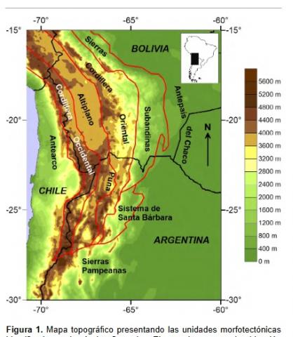
Los Andes Centrales están caracterizados por una serie de unidades morfoestructurales que presentan rasgos estratigráficos, es-tructurales y geomorfológicos distintivos. Destacan a simple vista las marcadas variaciones topográficas transversales al orógeno. Estudios teóricos sobre la elevación de los continentes han discretizado distintas componentes que contribuyen a la elevación obser-vada, prevaleciendo las contribuciones composicional y térmica. Investigaciones previas han demostrado que la región presenta una alta variabilidad en su composición cortical y estado termal. Estas variaciones podrían ejercer un control en la topografía regional, como ya ha sido señalado en un estudio previo del plateau Altiplano-Puna. En esta línea, este trabajo se propone investigar la re-lación entre la elevación actual de los Andes Centrales, su composición cortical y estado térmico. La contribución térmica esperada para cada unidad morfoestructural fue calculada en base al desarrollo de modelos térmicos 1D construidos utilizando datos de flujo térmico superficial. Con el objetivo de remover la contribución composicional de la corteza a la elevación observada, se calculó una elevación normalizada. Dicha elevación fue comparada con la contribución térmica estimada para evaluar su ajuste en cada unidad morfoestructural. El plateau Altiplano-Puna y la Cordillera Occidental muestran una buena correlación, sugiriendo que la composición y temperatura controlan su elevación actual. Por el contrario, en los otros sectores se observa un desajuste. El análisis detallado de cada unidad sugiere que los procesos tectónicos de subducción, las contribuciones del manto y los estados transitorios (i.e. no es-tacionarios, en desequilibrio) deben ser también considerados como contribuciones importantes al estado térmico y/o a la elevación actual.
The Central Andes of South America are characterized by different morphotectonic units that exhibit distinctive stratigraphic, structural, and geomorphic features. In particular, the topographic variations across the orogen are remarkably notorious. Theoretical studies on the elevation of continents have discretized distinct components that contribute to the observed elevation, among which the compositional and thermal contributions prevail. Previous investigations in the Central Andes have shown that the region presents a high variability in its crustal composition and thermal state. Such variations could exert a first-order control on the regional topography, as shown previously for the Altiplano-Puna plateau area. This study, therefore, sets out to investigate the relationship between the present-day elevation of the Central Andes, its crustal composition, and its thermal state. We first calculated the predicted thermal contribution for each morphotectonic unit based on 1D geotherms modeled on the basis of surface heat-flow data. In order to remove the compositional contribution of the crust, we then calculated a normalized elevation. This elevation was compared to the predicted thermal contribution to evaluate their fit in each morphotectonic unit. The Altiplano-Puna plateau and the Western Cordillera exhibit a good correlation, suggesting that composition and temperature control their present-day elevation. Conversely, the other areas show a significant misfit. The detailed analysis of the remaining morphotectonic units suggests that tectonic processes at the subduction zone, mantle contributions, and transient states need to be considered as important contributors to the present-day thermal state and/or elevation.
El Ediacarano (o Ediacárico) es el período terminal del Precámbrico, extendiéndose desde los 635 hasta los 541 millones de años (Ma). Durante ese lapso el planeta parece haber experimentado una serie de eventos y procesos extraordinariamente singulares, cuya real existencia y características detalladas son motivo de numerosos debates y controversias. Algunos de los acontecimientos que con mayor o menor certeza se investigan, discuten y analizan en la actualidad son: 1) la aparición de la primera biota compleja de organismos multicelulares de la historia de la Tierra pero que no dejaría sucesores en el Fanerozoico; 2) la mayor excursión isotópica de δ13C de la historia del planeta (excursión Shuram) y su relación con la evolución de los océanos; 3) la existencia de una glaciación que alcanzó bajas latitudes (glaciación Gaskiers) y sus impactos paleoambientales globales; 4) La cronología y cinemática de la ruptura final del supercontinente Rodinia y de la subsecuente formación del Gondwana; 5) la existencia de desplazamientos polares verdaderos muy
veloces y de cerca de 90° por intercambio de los ejes de inercia del planeta; 6) la posibilidad de que los polos magnéticos estuvieran ubicados durante largos lapsos en el ecuador; 7) un campo magnético ultradébil, con la menor paleointensidad registrada; 8) un campo magnético hiperactivo, con la máxima frecuencia de reversiones de polaridad conocida; 9) el posible inicio de la formación del núcleo interno y el subsecuente cambio en la modalidad de la geodínamo terrestre; entre varios más. A través de estudios paleomagnéticos sistemáticos es posible aportar información muy valiosa para resolver
muchos de estos interrogantes. Desde hace dos décadas, en el Laboratorio de Paleomagnetismo Daniel A. Valencio del IGEBA venimos desarrollando estudios multidisciplinarios sistemáticos en rocas sedimentarias y volcánicas ediacaranas del cratón del Río de la Plata. Estas investigaciones se nutren de una colaboración estrecha y continua con colegas de otros grupos de investigación de Argentina, Brasil y Uruguay. Los estudios incluyen principalmente investigaciones paleomagnéticas con el fin de reconstruir la evolución paleogeográfica del cratón en el Ediacarano y aportar a conocer la cinemática de la formación del Gondwana. Recientemente estamos también avanzando en el conocimiento de las reversiones de polaridad del paleocampo magnético en el Ediacarano tardío. Dataciones geocronológicas precisas, estudios isotópicos sistemáticos y recientes hallazgos fósiles espectaculares, sumados a la información paleomagnética, están aumentando significativamente nuestro conocimiento de un período hasta hace dos décadas casi desconocido. Estos avances incluyen una reconstrucción esquemática de la evolución paleogeográfica del cratón del Río de la Plata entre aproximadamente 600 y 550 Ma, durante el cual el mismo habría migrado desde bajas a altas latitudes. Con esta información y la de otros cratones de Gondwana Occidental están surgiendo restricciones a las edades de anexión con Congo-São Francisco y África Occidental. También permiten especular con mayor sustento observacional sobre la posible existencia (o no) de un gran océano llamado Clymene en etapas finales de formación del Gondwana. El probable registro de la excursión Shuram en sedimentos calcáreos del cratón es una posibilidad concreta a medida que avanzan los estudios quimioestratigráficos. Si bien aún de modo incipiente, los primeros resultados magnetoestratigráficos que estamos obteniendo sugieren la aparente presencia de rápidas reversiones de polaridad. Esta sucesión de nuevos resultados marca límites a ciertos modelos o propuestas no actualistas mientras que es compatible con otros, abriendo un importante número de nuevos interrogantes. En este trabajo se presenta un breve resumen del conocimiento actual a nivel global de muchas de estas controversias, así como del avance de las investigaciones en nuestro país.
Ediacaran (or Ediacaran) is the terminal period of the Precambrian, extending from 635 to 541 million years ago (Ma). During this period the planet appears to have experienced a series of extraordinarily singular events and processes, whose actual existence and detailed characteristics are the subject of much debate and controversy. Some of the events that are more or less certainly investigated, discussed and analyzed at present are: 1) the appearance of the first complex biota of multicellular organisms in Earth's history but which would leave no successors in the Phanerozoic; 2) the largest δ13C isotopic excursion in the history of the planet (Shuram excursion) and its relationship with the evolution of the oceans; 3) the existence of a glaciation that reached low latitudes (Gaskiers glaciation) and its global paleoenvironmental impacts; 4) the chronology and kinematics of the final rupture of the supercontinent Rodinia and the subsequent formation of Gondwana; 5) the possibility of very fast true polar displacements of about 90° by exchange of the inertial axes of the planet; 6) the possibility that the magnetic poles were located for long periods at the equator; 7) an ultraweak magnetic field, with the lowest paleointensity on record; 8) a hyperactive magnetic field, with the maximum frequency of known polarity reversions; 9) the possible beginning of the formation of the Internal nucleus and the subsequent change in the mode of the terrestrial geodynamo; and many more. Through systematic paleomagnetic studies it is possible to provide valuable information to resolve many of these questions. For two decades, in the Daniel A. Valencio Paleomagnetism Laboratory of the IGEBA we have been developing systematic multidisciplinary studies in sedimentary and volcanic Ediacaran rocks of the Río de la Plata craton. These investigations are nurtured by a close and continuous collaboration with colleagues from other research groups in Argentina, Brazil and Uruguay. The studies include mainly paleomagnetic investigations in order to reconstruct the paleogeographic evolution of the Ediacaran craton and to contribute to understand the kinematics of the formation of Gondwana. Recently we are also advancing in the knowledge of the polarity reversions of the magnetic paleofield in the late Ediacaran. Accurate geochronological dating, systematic isotopic studies and recent spectacular fossil finds, in addition to paleomagnetic information, are significantly increasing our knowledge of a period that until two decades ago was almost unknown. These advances include a schematic reconstruction of the paleogeographic evolution of the La Plata River craton between approximately 600 and 550 Ma, during which time it would have migrated from low to high latitudes. With this information and that of other West Gondwana cratons, constraints on the ages of annexation with Congo-São Francisco and West Africa are emerging. They also allow speculation with more observational support on the possible existence (or not) of a big ocean called Clymene in late stages of Gondwana formation. The probable record of the Shuram excursion in calcareous sediments of the craton is a concrete possibility as chemostratigraphic studies progress. Although still incipient, the first magnetostratigraphic resultswe are obtaining suggest the apparent presence of rapid polarity reversions. This succession of new results marks limits to certain models or non-current proposals while it is compatible with others, opening an important number of new questions. In this paper we present a brief summary of the current global knowledge of many of these controversies, as well as the progress of research in our country.
Guadalupe Arzadún, Renata Nela Tomezzoli, Natalia Fortunatti, Nora Noemi Cesaretti, María Belén Febbo & Juan Martin Calvagno
2 021
Scientific Reports volume 11 (2021)
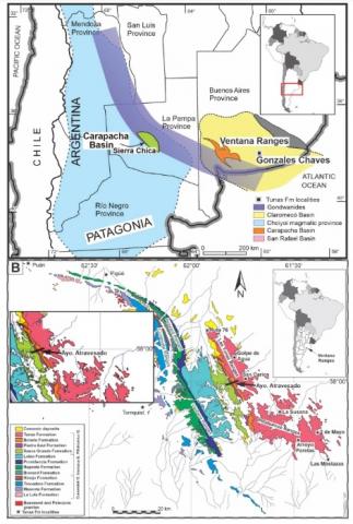
At the east of the Ventana Ranges, Buenos Aires, Argentina, outcrops the Carboniferous-Permian Pillahuincó Group (Sauce Grande, Piedra Azul, Bonete and Tunas Formation). We carried out an Anisotropy of Magnetic Susceptibility (AMS) study on Sauce Grande, Piedra Azul and Bonete Formation that displays ellipsoids with constant Kmax axes trending NW–SE, parallel to the fold axes. The Kmin axes are orientated in the NE–SW quadrants, oscillating from horizontal (base of the sequence-western) to vertical (top of the sequence-eastern) positions, showing a change from tectonic to almost sedimentary fabric. This is in concordance with the type and direction of foliation measured in petrographic thin sections which is continuous and penetrative to the base and spaced and less developed to the top. We integrated this study with previous Tunas Formation results (Permian). Similar changes in the AMS pattern (tectonic to sedimentary fabric), as well as other characteristics such as the paleo-environmental and sharp curvature in the apparent polar wander path of Gondwana, marks a new threshold in the evolution of the basin. Those changes along the Pillahuincó deposition indicate two different spasm in the tectonic deformation that according to the ages of the rocks are 300–290 Ma (Sauce Grande to Bonete Formation deposition) and 290–276 Ma (Tunas Formation deposition). This Carboniferous-Permian deformation is locally assigned to the San Rafael (Hercinian) orogenic phase, interpreted as the result of rearrangements of the microplates that collided previously with Gondwana, and latitudinal movements of Gondwana toward north and Laurentia toward south to reach the Triassic Pangea.
Acta Geológica Lilloana 33 (1): 25-42, 7 de junio de 2021
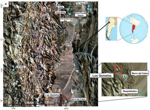
El área Los Gemelos (31° 58’ 26’’ S, 69° 36’ 7’ O) se enmarca en la Cordillera Frontal de la provincia de San Juan, Argentina, en la porción sur del segmento de subducción horizontal pampeano de los Andes Centrales. Estudios petro - mineralógicos de muestras de superficie permitieron establecer la presencia de un cuerpo subvolcánico dacítico y otro daci-andesítico, ambos hospedados en rocas volcaniclásticas de edad pérmica media. A partir del análisis de los datos de geoquímica se determinó que el pulso magmático que generó dicho intrusivos habría sido producto de un magmatismo de arco emplazado en una corteza de espesor normal (~30 km) en transición a una de espesor intermedio (~45 km), caracterizado por el elevado contenido de álcalis (en particular del Na2O) que se interpreta como una característica intrínseca de estos magmas. Por las semejanzas en cuanto al modo de yacer, textura y composición mineralógica con otras vulcanitas de edad miocena que afloran en el ámbito de la Cordillera Frontal y Principal sanjuanina y que constituyen las rocas hospedantes de depósitos mineralizados (Chita, Co.Bola, Qda. de las Minas, Pachón y Morro del Cobre), se le asigna preliminarmente una edad miocena al pulso magmático que generó los intrusivos del área de estudio.
Los Gemelos area (31°58’26’’S, 69°36’7”W) is located in the Frontal Cordillera of San Juan province, Argentina, over the southern part of the Pampean flat slab segment of the Central Andes. Petro-mineralogical studies of surface samples allowed establishing the presence of a dacitic and a dacitic-andesitic subvolcanic bodies, both hosted in Middle Permian volcaniclastic rocks. By means of a comparative geochemical study, similarities could be established between the subvolcanic rocks of the study area and Miocene rocks from Frontal and Main Cordillera, and Western Precordillera. This allowed determining that the dacitic-andesitic body (Western Intrusive) resembles the Divisadero Sur and Cerro Puntas Negras units, both assigned to the Middle Miocene. These rocks would have originated in a normal thickness crust where there was no fractionation of plagioclase due to high pH2 O conditions. On the other hand, the dacitic body (Eastern Intrusive) shows geochemical characteristics similar to those of El Altar, Chita, Cerro Bola and Cerro Negro Upper Miocene units with an amphibole in transition to garnet residual mineralogy equilibrated under crustal thickening conditions.
Sergio A. Marenssi; Carlos O. Limarino; Laura J. Schencman; Patricia L. Ciccioli
2 020
Journal of Sedimentary Research (2020) 90 (2): 250–267.
Two episodes of lacustrine sedimentation, separated by an erosional surface and fluvial sedimentation, took place in the southern part of the broken foreland Vinchina basin (NW Argentina) between 11 and 5 Ma. The lacustrine deposits, 768 and 740 meters thick, are recorded in the upper part of the Vinchina Formation (“Vinchina lake”) and the lower part of the Toro Formation (“Toro Negro lake”) respectively. According to sedimentological features, four sedimentary facies associations (FAs) are recognized in the lacustrine deposits: 1) thinly laminated mudstones facies association (FA 1), 2) coarsening- and thickening-upward muddy to sandy cycles (FA 2), 3) medium- to coarse-grained sandstones (FA 3), and 4) mudstones, sandstones, and oolitic limestones (FA 4). Altogether, these facies correspond to ephemeral, shallow, lacustrine systems including saline mudflats. The total thickness of each lacustrine interval, the thickness of the individual cycles and their lithology, and the overall aggradational facies arrangement suggest that both lakes developed during underfilled stages of the basin. The coarsening-upward cycles can be regarded as lacustrine parasequences representing cyclic episodes of expansion and contraction of the lake, but unlike marine parasequences these cycles do not correlate to water depth. The development of lacustrine conditions and continuous base-level rise, together with the coeval southward-directed paleoflow indicators, suggest axial drainages and that the basin was externally closed (endorheic) at that time. The large thicknesses of each lacustrine interval also points to high accommodation in the southern part of the Vinchina basin during these times. Lake filling cycles are one order of magnitude thicker than lake depth, so we postulate that subsidence (tectonic) and rise of the spill point (geomorphology) increased accommodation but not water depth. Thus, unlike marine parasequences, the analyzed coarsening-upward cycles do not correlate to water depth, but rather they are controlled by more complex basinal accommodation processes. We hypothesize that the coeval uplift of the Umango and Espinal basement block to the south, coupled with the initial doming of the Sierra de Los Colorados to the east, may have generated the damming of the southward-directed drainage and a zone of maximum accommodation, then controlling the location of the two lakes and the preservation of their thick sedimentary records. Therefore, localized accommodation was enhanced by a combination of tectonic subsidence and topographic growth. The two lacustrine intervals and the intervening fluvial deposits record changing contributions from axial to transverse drainages and different cycles of closed and open conditions in the basin. A low-frequency, closed to open and back to closed (axial to transverse and return to axial drainage) basin evolution, is envisaged by the development of the two lakes (closed stages) and the erosional surface followed by the interval of fluvial sedimentation that separates them (open stage). In addition, several high-frequency lake fluctuations (expansion–contraction) are represented by the coarsening-upward cycles within each lacustrine interval. The thick lacustrine intervals and their intermediate incision surfaces record cyclic filling and re-excavation stages and localized episodes of increased subsidence in the Vinchina basin, which seem to be a common feature of tectonically active broken foreland basins.
Pablo J. Alonso-Muruaga, Carlos O. Limarino, Luis A. Buatois y Cecilia A.Pirrone
2 020
Revista de la Asociación Geológica Argentina 77 (3): 427-446 (2020)
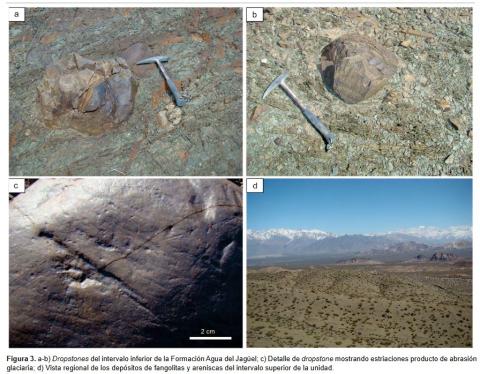
Se describen las características paleoambientales e icnológicas del tramo medio de la Formación Agua del Jagüel (Carbonífero, Precordillera de Mendoza). Fueron reconocidas cinco facies agrupadas en tres asociaciones de facies sedimentarias, las que caracterizan la evolución de un sistema fluvio-estuarino. La asociación de facies 1, formada por conglomerados y areniscas conglomerádicas de origen fluvial, se dispone sobre una superficie erosiva que los separa de niveles postglaciales correspondientes a la parte basal de la Formación Agua de Jagüel. La asociación de facies 2 incluye en su base a depósitos finos (fangolitas) que indican la inundación del sistema, seguida por sedimentación arenosa correspondiente a ambientes de boca de estuario indicando una progresiva transgresión dentro del estuario. La asociación de facies 3 corresponde a dos intervalos de areniscas muy gruesas fluviales, separados por areniscas muy finas y fangolitas depositadas durante un breve evento transgresivo. Paralelamente a los estudios sedimentológicos se analizaron las estructuras biogénicas provenientes de fangolitas y areniscas muy finas a finas de la facies 2.
Las trazas fósiles reconocidas incluyen a Cochlichnus anguineus, Gordia marina, Helminthoidichnites tenuis, Helminthopsis tenuis, Mermia carickensis, Treptichnus bifurcus, T. pollardi, y trazas en rosario. Esta asociación icnológica muestra moderada diversidad y baja icnodisparidad que sugieren condiciones de estrés ambiental, probablemente vinculadas a importantes fluctuaciones de salinidad dentro del estuario. La presencia de la icnofacies de Mermia en estos depósitos es una nueva evidencia de que los sistemas depositacionales marino marginales postglaciales estuvieron fuertemente afectados por significativas descargas de agua dulce al producirse la deglaciación del Paleozoico tardío.
Sedimentology and ichnology of the middle interval of the Agua del Jagüel Formation, Carboniferous of Mendoza Precordillera: paleoenvironmental implications of the postglacial transgression. The paleoenvironmental and ichnological characteristics of the middle section of the Agua del Jagüel Formation (Carboniferous) are described in this paper. Five sedimentary facies, grouped into three facies associations illustrating the evolution of a fluvio-estuarine system, were identified. Facies association 1, composed of fluvial conglomerates and coarse-grained sandstones, rests on an erosive surface carved into postglacial diamictites, sandstones, and shales belonging to the lower part of the Agua del Jagüel Formation.
Romina Sanci, María J. Orgeira, Andrea Coronato, Rita Tófalo, Héctor O. Panarello, Diego Quiroga, Ramiro López, Pedro Palermo and Claudia S. Gogorza
2 021
Quaternary Research Vol 102. July 2021 , pp. 53 - 67
A late Pleistocene glaciolacustrine record was studied at Fagnano Lake (54°35´S, 67°20´W), central Isla Grande de Tierra del Fuego, southernmost South America. Two profiles from the Río Valdéz outcrop were collected for isotopic, geochemical, sedimentological, and geophysical analyses. The sedimentological characteristics, such as rhythmites, presence of dropstones, absence of fossil record, and scarce presence of organic matter, suggest deposition in an ice-contact lake, possibly dammed by the Fagnano paleoglacier. Organic matter of C3 plant origin suggests certain cold and wet conditions. A chronology of the late Pleistocene outcrop was obtained from five 14C ages resulting in an age-depth model. The time span covered 49.01 cal ka BP to 32.14 cal ka BP. Based on the thickness of the deposit and the calculated average sedimentation rate, the glacial environment could have been present in the study area prior to the last glacial maximum, in agreement with the Inútil-San Sebastián paleoglacier. Both glaciers flowed from the same mountain ice sheet in the Darwin Cordillera, which makes it possible to infer a different behavior of this ice cap from those of the Patagonian Andes, perhaps forced by different atmospheric dynamics and proximity to the wet and cold subantarctic air masses.
Revista de la Asociación Geológica Argentina. Vol 14 (2021)
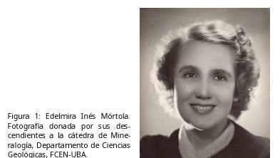
Edelmira Mórtola fue la primera geóloga de la República Argentina al obtener, en 1921, el título de doctora en Ciencias Naturales de la Universidad de Buenos Aires. Se desempeñó en la Dirección General de Minas y Geología entre 1918 y 1923, y fue la primera profesional mujer de esa Institución. Dictó cursos de Mineralogía y Petrografía en los Doctorados en Ciencias Naturales y Química, e Ingeniería Civil, en la Facultad de Ciencias Exactas, Físicas y Naturales de la Universidad de Buenos Aires, actualmente Facultad de Ciencias Exactas y Naturales - FCEN - UBA. En 1956, llegó a ser la primera profesora titular de esta Facultad. Dedicó su vida a enseñar y a organizar el Gabinete de Mineralogía y Petrografía de la FCEN-UBA. Propició el desarrollo de la Mineralogía en nuestro país, que al presente cuenta con numerosos centros de excelencia fundados por sus discípulos. Fue una mujer relevante para el desarrollo nacional; su opinión, visión y consejo eran solicitados por lo más encumbrados académicos y autoridades gubernamentales de la época en los tiempos de consolidación de la ciencia argentina. Palabras clave: Mineralogía, colecciones mineralógicas argentinas, Profesora Titular FCEN-UBA, mujer científica.
Edelmira Mórtola, the first geologist of República Argentina Edelmira Mórtola was the first female geologist of the República Argentina and in 1921 she obtained a Ph. D. in Natural Sciences from the University of Buenos Aires. She worked in the Direction of Geology and Mines between 1918 and 1923, and was the first female professional of that Institution. She taught courses on Mineralogy and Petrography in the Doctorates in Natural Sciences and Chemistry, and Civil Engineering, at the Facultad de Ciencias Exactas, Físicas y Naturales, Universidad de Buenos Aires, currently Facultad de Ciencias Exactas y Naturales (FCEN UBA). In 1956 she became the first Full Professor of that Facultad. She devoted her life to teaching and organizing the Cabinet of Mineralogy and Petrography. She fostered the development of Mineralogy in our country, which currently have numerous centers of excellence founded by her disciples. She was a relevant woman for national development, her opinion, foresight and advice were requested by the highest academics and government authorities in times of consolidation of Argentine science.
Journal of Coastal Research, Volume 37, Issue 3 May 2021
The main contribution of this paper is a new interpretation of the geomorphological evolution of the North Patagonian coast surrounding the Golfo Nuevo from Mid-to-Late Pleistocene until present. The proposed model shows how continental and marine landforms evolved during the Late Quaternary. According to this, the Golfo Nuevo depression formed during the Middle Pleistocene (>130 ka) above previous fluvial terraces, which are attributed to different stages of the Chubut river. Several pediment types and levels were also identified: (1) flanking pediment (level 1) associated with an ancient fluvial valley; (2) convergent pediment related to a previous depression of Golfo Nuevo (level 2), both assigned to Middle Pleistocene; and (3) a littoral pediment (level 3) linked to a Holocene highstand level. The height and position of accretion marine terraces are discussed, in addition to their previous dating. It can be assumed that Golfo San Matías was flooded twice as a consequence of marine transgressions (marine isotopic stage [MIS] 5 and MIS 1). Likewise, Golfo Nuevo and Golfo San José were affected only once, during the maximum Holocene transgression (MIS 1). This paper highlights the importance of reconstructing the geomorphological evolution of a coastal area of the Patagonia as a result of a combination of changes linked to sea-level variations (mainly associated with glacio-eustasy) and climate, paleo-shorelines records, and continental landforms through Late Quaternary. The proposed geomorphological model can be considered a novelty because of the complex integration of continental and marine landforms and the study of their relative relation.
Gallo, Magdalena; Tripaldi, Alfonsina; López, Rubén; Marcomini, Silvia Cristina; Orgeira, Maria Julia
2 021
merican Journal of Sedimentology and Basin Analysis. Vol. 28 Núm. 1 (2021)
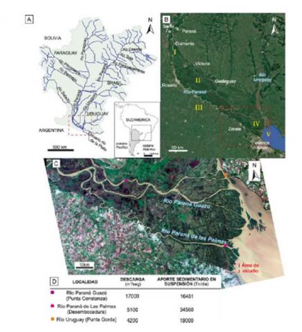
El delta del río Paraná (DRP) constituye un delta de cabecera de estuario, con morfología lobada, dominado por acción fluvial, regulado por el régimen hidrológico de su cuenca de drenaje y la dinámica del estuario interior del Río de la Plata (RdP). De régimen micromareal y oleaje de baja amplitud (en promedio menor a 0,6 m), el estuario desarrolla (en promedio 2 veces al año) condiciones excepcionales de niveles positivos del agua, debido a fuertes vientos del sudeste (sudestadas), y negativos, por bajantes extraordinarias por vientos intensosdel noroeste. El delta se desarrollódurante los últimos ca. 2000 años en la desembocadura del río Paraná, sumando contribuciones sedimentarias secundarias del río Uruguay. El río Paraná aporta 160 millones de toneladas anuales de sedimentos limo-arenosos en la cabecera de un estuario somero y de grandes dimensiones (profundidad promedio menor a 10 m, 320 km de extensión, 40 km de ancho).Estudios previos mostraron altas tasas de progradación del delta (42-45 m por año desde ca. año 1933 en el sector estudiado). Con el objetivo de caracterizar los depósitos de esta progradación deltaica y contribuir a los modelos de facies de deltas de cabecera de estuario se realizó un análisis geomorfológico-temporal y sedimentológico, incluyendo relevamientos-muestreos de campo, y análisis de laboratorio de sedimentos superficiales y de testigos de sedimento de un sector del delta del río Paraná. Se definieron litofacies en función de un estudio textural-estadístico, diferenciación de subpoblaciones mediante miembros extremos (ME) y características de los testigos. La caracterización sedimentológica de los testigos apoyada por el análisis de ME, las tendencias de LOI550, LOI950 y susceptibilidad magnética, junto con los rasgos y evolución geomorfológica de los sitios de muestreo permite proponer una serie de asociaciones de facies. Se infiere que estas asociaciones de facies representan distintos subambientes del área estudiada y constituyen una herramienta para el análisis de deltas de cabecera formados por grandes ríos, de carga sedimentaria limo-arenosa, en estuarios dominados por mareas. Los depósitos conforman dominantemente sucesiones con tendencia grano-decreciente, de limos arenosos y arenas limosas, bajas proporciones relativas de arcillas (máximo promedio del 20%) y abundantes estructuras heterolíticas y niveles masivos. La alta dinámica constructiva del delta del río Paraná, evidenciada en avances de decenas de metros por año, queda expuesta también en tasas de acreción vertical estimadas de entre 1,5 y 2,5 cm por año, estimada en base a la correlación con información publicada de testigos fechados en inmediaciones del área de estudio y a edades relativas en función de la presencia del bivalvo invasor Corbícula fluminea (ca. año 1970) en los depósitos estudiados.