Cecilia A. Wunderlin, Gilda Collo, Miguel Ezpeleta, Virginia V. Reinoso Carbonell, Julieta C. Nóbile, Patricia L. Ciccioli, Sonia Faudone
2 022
Sedimentary Geology Volume 437, 15 July 2022
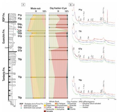
New X-ray diffraction (XRD) data, scanning electron microscopy (SEM) analysis, and X-ray energy dispersive spectrometry (EDX) microanalysis on clay minerals are presented for Cretaceous-Cenozoic sedimentary sections studied in the La Flecha and La Troya Sur creeks, located in the Argentine Precordillera. The characterization of clay mineral assemblages, including the discrimination of detrital and authigenic phases, allows inferences to be made about paleoclimatic and paleoenvironmental conditions as well as the postsedimentary history of these foreland clastic sedimentary depocenters. Mineralogical analyses carried out in the Cretaceous Ciénaga del Río Huaco Fm. and the Cenozoic Puesto La Flecha, Vallecito, Vinchina, and Zapallar Fms. show the presence of illites, smectites, illite/smectite mixed-layer clays (I/S, with R0 and R1 ordering types), sporadic corrensite, and subordinate amounts of chlorite and kaolinite, among other non-clay phases, such as analcime and heulandite. Illite and chlorite are interpreted as detrital phases, reflecting the composition of the source area, and smectite, I/S R0 and R1, and corrensite are interpreted as authigenic phases developed in the matrix or as massive pore filling within the clastic levels. Compositional analyses allow for smectites to be characterized as di- and trioctahedral Mgrich, and are interpreted as a product of the combination of two main controls: (1) that from the parent material (volcaniclastic material and magnesian silicates) and (2) that of the primary composition of pore fluids associated with alkaline lake systems. These smectites are precursors of prograde diagenetic phases developed under a low thermal regime (< 120 °C). R0 and R1 I/S formed from Mg-dioctahedral smectites mainly within the matrix, with an increase of illite % in R0 and R1 with depth, and corrensite formed from trioctahedral Mgsmectites mainly as massive pore fillings. Finally, the conclusions obtained from these new data reinforce that, in some cases, authigenic phases associated with mesogenesis (e.g., corrensite) would allow us to make inferences about the precursor authigenic material and
therefore about some paleoenvironmental conditions. This, in turn, underlies the importance of making detailed analyses of clay mineral assemblages in reconstructions of the sedimentary and post-sedimentary history of basins close to areas with active tectonism, such as foreland basins.
El Dr. Sebastián Oriolo, integrante del IGeBA ha sido designado Investigador independiente del CONICET.
Nos es grato comunicar que el Dr. Sebastián Oriolo, Jefe de Trabajos Prácticos de la UBA, Investigador del CONICET y de nuestro instituto, IGeBA, ha sido designado Investigador Independiente del CONICET.
El IGeBA felicita al Dr. Sebastián Oriolo por tan importante designación.
El Dr. Roberto Scasso, integrante del IGeBA ha sido designado Investigador Superior del CONICET.
Nos es grato comunicar que el Dr. Roberto Scasso, Profesor Titular Regular Ordinario de la UBA, Investigador del CONICET y Director de nuestro instituto, IGeBA, ha sido designado Investigador Superior del CONICET.
La Dra. Claudia Prezzi, integrante del IGeBA ha sido designada Investigadora Principal del CONICET.
Nos es grato comunicar que la Dra. Claudia Prezzi, Profesora Asociada Regular Exclusiva de la UBA e Investigadora del CONICET y vice-directora de nuestro instituto, IGeBA, ha sido designada Investigadora Principal del CONICET.
Boletín de Geología vol. 44, n.° 1, enero-abril de 2022
Se analizan la morfología y evolución de los diapiros y volcanes de lodo en el Margen Caribeño Colombiano (MCC), emplazados en secuencias sedimentarias transgresivas del Cretácico al Neógeno. Son estructuras extrusivas por argilocinesis que muestran la liberación de sedimentos sobrepresionados y fluidizados por aguas y/o hidrocarburos que intruyen hasta la superficie. A partir de la modelación analógica, se concluye que los condicionantes del origen y geometría de los mecanismos del diapirismo dependen de: i) la menor densidad de los niveles generadores infrayacentes en comparación con las secuencias suprayacentes y ii) de las débiles tasas de sedimentación de las secuencias que los post-datan. La exhumación progresiva del Cinturón Sinú-San Jacinto a partir del Oligo-Mioceno, debido a la convergencia tectónica transpresiva dextral entre las placas Sudamérica y Caribe, generó una barrera al transporte sedimentario hacia el norte del paleo río Cauca. Esta interrupción impidió su descarga directa, forzándolo a coalescer hacia el río Magdalena. Se propone un provincialismo del diapirismo a partir de las diferencias en las tasas de progradación de sedimentos más densos sobre secuencias pelíticas asociadas con conspicuos tipos de plegamientos intensos: a) al norte (Cinturón San Jacinto), compresional tangencial con ejes de pliegues doblemente buzantes y escalonados subparalelamente al litoral Caribe y b) al sur (Cinturón Sinú), gravitatorio con amplios sinclinales en forma de cubetas y anticlinales estrechos. El mejor conocimiento de la evolución 4D del diapirismo en el MCC contribuye en la definición del potencial de los sistemas petroleros infrayacentes y en la prevención de riesgos ambientales en las maniobras exploratorias.
The morphology and evolution of diapirs and mud volcanoes in the Colombian Caribbean Margin (MCC) located in transgressive Cretaceous to Neogene sedimentary sequences are analyzed in this paper. They are extrusive structures by argilokinesis that show the release of overpressure and fluidized sediments by water and/or hydrocarbons that pierce the surface. From the analogical modeling of the determining factors of origin and geometry, the diapirism mechanisms depend on: i) the lower density of the underlying generating levels compared to the overlying sequences, and ii) the weak sedimentation rates of the overlayered sequences. The progressive exhumation of the Sinú-San Jacinto Belt from the Oligo-Miocene period due to the dextral transpressive tectonic convergence between the South American and Caribbean plates, generated a barrier to sedimentary transport to the North of the Paleo Cauca River. This interruption prevented its direct discharge, forcing it to coalesce into the Magdalena River, increasing the volume of its delta. A provincialism of diapirism is proposed based on the differences in rates and chronologies of the progradation of denser sediments on pelitic sequences associated with conspicuous types of folds: a) to the north (San Jacinto Belt), tangential compressional type with a double plunge, and oriented subparallel to the Caribbean coast, and b) to the south (Sinú Belt), gravitational type with wide synclines and tight anticlines. Better knowledge of the 4D evolution of MCC diapirism contributes the potential of the underlying oil systems and the prevention
of environmental risks in exploratory maneuvers.
Ana Paula Orellano Ricchetti, Anabel L.R. Gómez, Nora A. Rubinstein, Carmen I. Martínez Dopico y Cristiano Lana
2 022
Revista de la Asociación Geológica Argentina Volumen 79 (2) 2022
Edad U-Pb de la Formación Agua de la Zorra en el área de Paramillos, Precordillera de Mendoza.
Esta contribución reporta una nueva edad U-Pb en zircones de un nivel de tobas de la Formación Agua de la Zorra (Grupo Uspallata) que forma parte del relleno de rift triásico de la cuenca de Cuyo en el depocentro Paramillos, Precordillera de Mendoza. La Formación Agua de la Zorra aloja la mineralización de vetas polimetálicas de Paramillos de Uspallata. Los resultados de los análisis LA-ICP-MS U-Pb en circones sugieren una edad triásica superior (230.2 ± 2.2 Ma) para la Formación Agua de la Zorra. Los resultados obtenidos son consistentes con la edad del volcanismo en otras áreas de la cuenca de Cuyo.
The Agua de la Zorra Formation (Uspallata Group) constitutes the rift infill of the Paramillos depocenter from the Cuyo basin located in the Argentine Precordillera. This unit hosts the Paramillos de Uspallata polymetallic vein-deposit. In this contribution we report a new LA-ICP-MS zircon U-Pb age of 230.2 ± 2.2 Ma (Upper Triassic) for a tuff level that belongs to the Agua de la Zorra Formation. The obtained age is consistent with the age of the volcanism in other areas of the Cuyo basin.
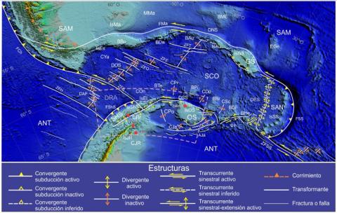
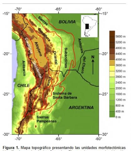
The Sierra Nevada de Santa Marta (Santa Marta) in Colombia and Nevado del Famatina (Famatina) in Argentina are two isolated peaks within the Andes of South America, having elevations of about 5,500 and 6,000 m, respectively. Both massifs are bounded by major wrench faults of opposite kinematics but comparable magnitude in their lateral displacement. Despite the volumes of research available, little has been said in the literature about the tectonics surrounding these particular systems. In this context, digital terrain elevation (DEM), regional geology, satellite imagery and geophysical data were analysed to illustrate how a network of transcurrent faults uplifted the peaks. We propose a model to account for topography by the opposed movement of faults operating in two compartments: internal (acute) and external (obtuse). Fault motion caused uplift of the internal compartments: a) the Santa Marta tectonic syntaxis is generated by the sinistral Santa Marta-Bucaramanga Fault on the west and the dextral Oca-Pilar Fault to the north whilst, b) the Famatina tectonic syntaxis is caused by the Valle F´ertil sinistral fault on the western side and the dextral Tucum´an lineament to the north. Elevation maps documenting the lateral displacement of modern alluvial fans provide evidence of the existence and kinematics of these faults. Active since the Neogene, the transcurrent faults resulted in displacements in the order of 25–60 km, with velocities of approximately 1–2 cm/year. Seismic records suggest that the syntaxis occurred after reactivation of oblique discontinuities in the basement due to the convergence of the Nazca, Caribbean, and South American plates. This tectonic framework led to the formation of a remarkable positive relief and the development of internal positive compartments subject to onstrictive forces. Simultaneously, external distensive and negative compartments controlled the syntectonic deposition of thick sedimentary sequences. The significant topographic difference between the internal positive compartments and their external negative counterparts triggered high rates of erosion, transport, and ultimately sedimentation. Regional subsurface surveys indicate strong anomalies of the underlying bedrock influenced by tectonic syntaxis.
Eduardo A. Rossello, Jorge Patricio Jones y Cintia Marquetti
2 022
Revista de la Asociación Geológica Argentina - Volumen 79 (1)
Se describen la geología y el potencial exploratorio de las manifestaciones epitermales polimetálicas de Cerro Cuadrado y El Bagual localizadas en el extremo noroccidental de la provincia de Santa Cruz. Ambas manifestaciones están temporal y espacialmente vinculadas con el emplazamiento y depositación de las unidades ácidas lávicas y piroclásticas de la Formación El Quemado, asociadas al plateau jurásico del Macizo del Deseado en la Patagonia austral. Las principales mineralizaciones de Cerro Cuadrado y El Bagual se disponen a lo largo de corredores de fallamientos submeridianales en las porciones cuspidales y/o en las periferias de estructuras dómicas de diámetros de varias centenas de metros. En el Cerro Cuadrado constituyen vetas, vetillas y brechas hidrotermales ricas en Ag y Zn, asociadas a flexuras dilatantes de fallamientos en las porciones centrales del domo. En El Bagual, se destacan las presencias de venas auroargentíferas y de un cuerpo intrusivo tardío cilíndrico subvertical de unas decenas de metros de diámetro denominado Chimenea Central. Está constituido por una diatrema de brechas y aglomerados volcánicos con litoclastos subangulares metamórficos provenientes de la infrayacente Formación Río Lácteo, del Paleozoico superior. Ambas manifestaciones polimetálicas confirman el potencial exploratorio de la zona.
Palabras clave: mineralizaciones polimetálicas
Geology and exploratory potential of the Cerro Cuadrado and El Bagual polymetallic epithermal manifestations (Santa Cruz, Argentina). The geology and exploratory potential of the polymetallic (Ag-Zn rich) epithermal manifestations of Cerro Cuadrado and El Bagual, located in the northwestern corner of the Santa Cruz province, in southern Patagonia, are described. Both manifestations are temporal and spatially associated with the emplacement of a dome and pyroclastic eruptive felsic units of the El Quemado Formation, related to the Jurassic plateau of the Deseado Massif. The main mineralization at Cerro Cuadrado and El Bagual occurs in veins, veinlets and brecciated areas along N-S trending fault corridors associated with apical portions and in the peripheries of domic structures with several hundred meters in diameter. In the Cerro Cuadrado, the mineralization is preferentially arranged in narrow vein corridors and banded areas rich in Ag and Zn that increase their thickness in dilating jogs of faults in the central portions of the dome. In the El Bagual, gold-silver veins and the presence of a subvertical cylindrical late intrusive body of a few dozen meters in diameter, called the Central Chimney, this structure represents a diatreme filled with volcanic agglomerates with metamorphic subangular lithic fragments of the underlying the Late Paleozoic Rio Lácteo Formation. Both polymetallic manifestations present a very interesting exploratory potential related to the outer areas of a Jurassic rhyolitic dome-complex model.
Franck Eitel Kemgang Ghomsi, Luan Thanh Pham, Robert Tenzer, Federico D.
Esteban, Tich Van Vu & Joseph Kamguia
2 022
Geocarto International Volume 37, 2022 - Issue 25
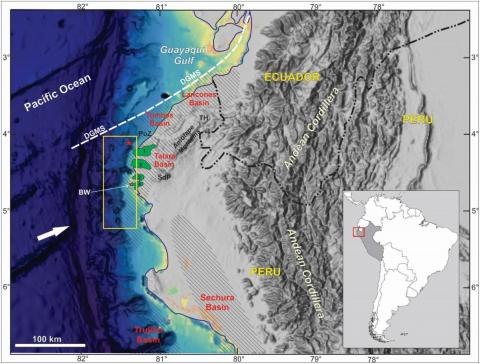
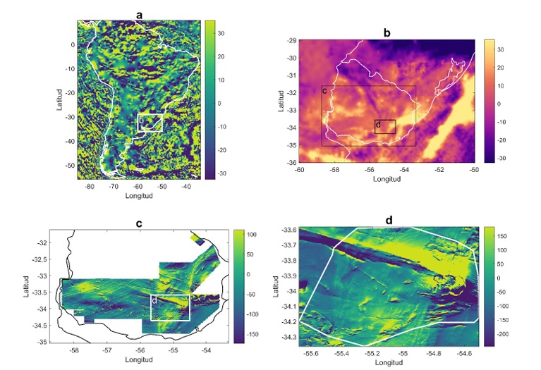
Satellite gravity datasets have been widely used in understanding of the Earth's internal structure and processes. These datasets are effective in providing insights into the lithospheric structure of the Earth. Gravity data from the satellite products CryoSat-2 and Jason-1 have been used to investigate the Gulf of Guinea sedimentary basins and structural lineaments in this under-explored marginal sea region through the application of various edge filters. Present-day filtering methods such as the analytical signal, tilt angle of the gradient amplitude, NTilt gradient amplitude and softsign function were evaluated for their performance on synthetic gravity anomalies with and without noise prior to their application to gravity data covering the Gulf of Guinea. The softsign filter outputs obtained from synthetic examples result in higher resolution and more explicit edges while preventing fictitious edges production in the findings. The results of the data interpretation disclosed deep-seated and shallow structural features within the Gulf of Guinea oriented mainly in the WNW-ESE, NW-SE, NE-SW and NNE-SSW directions and seen to be concentrated in the upper slope domain. This observation is in good agreement with the occurrence of drag folds and the apparent concentration of wrench faulting features across the ridge top and bordering the upper slope. These results bring new facts ruling our understanding of this atypical regional tectonic setting in close agreement with the NE–SW-striking Pelusium Megashear Zone.
Eduardo Garzanti, Tomas Capaldi, Alfonsina Tripaldi, Marcelo Zarate, Mara Limonta, Giovanni Vezzoli
2 022
Earth-Science Reviews Volume 231, August 2022
We here review in terms of tectono-magmatic setting and Quaternary landscape dynamics what is known about
the provenance of Argentine dune fields and their fluvial feeder systems draining the Andean Cordillera. The
detrital signatures of these eolian sediments were previously investigated based on either framework petrography and heavy minerals or detrital-zircon geochronology, and their peculiar volcaniclastic nature was long
recognized. Compositional variability, however, was only broadly evaluated, and quantitative provenance
analysis based on a systematic multimethod approach across the entire region was not carried out so far. For this
reason, here we integrate original and previously obtained petrographic, heavy-mineral, and detrital-zircon
geochronology data to present the first comprehensive provenance study of dune fields stretching for 1000
km across central Argentina from the Andean piedmont to the Atlantic Ocean.
In dune fields along the Andean retroarc basin, sediment composition defines a steady northward decrease in
volcanic detritus. This reflects active magmatism in the Southern Volcanic Zone and Payenia province (38◦-
34◦S), in contrast with the ~600-km-long Pliocene-Quaternary magmatic gap in the Pampean flat-slab segment
(33◦-27◦S), where sediment is derived from deeper-seated tectono-stratigraphic levels of the continental arc and
uplifted blocks of retroarc-basin basement. In distal Pampean lowlands extending across the bulge and backbulge
depozones, instead, sand dunes display notably homogeneous compositional signatures, indicating that detritus
was mostly generated north of 34◦S and transported by a paleo-Desaguadero trunk river that formed during
southward-progressing diachronous uplift of the Sierras Pampeanas since the late Miocene. In contrast with huge
African and Arabian deserts that contain multiply recycled quartzose to pure quartzose sand, even very fragile
volcanic clasts, plagioclase feldspar, and unstable ferromagnesian minerals are widespread, testifying to largely
first-cycle volcanic provenance and only minor effects of mechanical breakdown and chemical weathering in the
Pampean Sand Sea.
During the Late Pleistocene, after a first southward shift of the Desaguadero trunk river possibly induced by
increased water and sediment discharge at the end of the penultimate glacial maximum, tectonic uplift eventually outpaced stream power during the last glacial period. Paleo-rivers were thus forced to shift farther
southwards, leading to the formation of an integrated paleo-Desaguadero+Colorado drainage system. During the
latest Pleistocene-early Holocene, such a large trunk river fostered the rapid progradation of a wide delta and
littoral sand transport all along the shores of the Buenos Aires Province. Climate change and repeated waxing and
waning of glaciers through the Quaternary have left a prominent mark on sediment distribution, dominated by
fluvial processes during periods of high fluvial discharge but alternating with arid phases characterized by
limited transport capacity and vegetation cover, extensive wind deflation of floodplains, and sand accumulation
in the dune fields.