A. Cukjati, C. M. Spagnuolo, P. R. Franceschinis, M. Bellante, M. A. Naselli, M. G. López de Luchi & A. E. Rapalini
2 025
International Journal of Earth Sciences, 13 September 2025
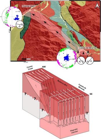
The development and emplacement of magmatic bodies during the Middle Paleozoic along the western margin of Gondwana remain poorly understood. To better constrain the nature of these processes, petrographic, anisotropy of magnetic susceptibility (AMS), anisotropy of anhysteretic remanent magnetization (AARM) and rock magnetic studies were performed in 326 specimens from 23 sites on Late Famennian—Early Tournaisian (∼357 Ma) basic dike swarms exposed at the Cuesta de Miranda (29°20′26″S; 67°46′3″W) and the Cosme Creek (29°15′27″S; 67°53′4″W) localities in the southwestern Famatina System, La Rioja province, Argentina. AMS results reveal that in the Cuesta de Miranda area, the maximum anisotropy axis (K1) is in a sub-vertical position, while in the Cosme Creek, it is dipping ∼40° towards the ESE, parallel to the strike of the dikes. Rock magnetic studies suggest that magnetite is the main mineral contributing to susceptibility. AARM studies confirm that the main axes of the susceptibility ellipsoid given by the AMS correspond to a “normal” fabric. The obtained results allow us to propose an emplacement model, in which the magmatic source that originated the dikes of the Cuesta de Miranda area was located under this region leading to a vertical flow of the magma at this locality. In the Cosme Creek, magma emplacement occurred due to an oblique upward flow that migrated around 15 km towards NW. In this area, all dikes exhibit similar AMS patterns despite petrographic differences among them. This suggests the emplacement of different magma pulses controlled by pre-existing regional structures.
Earth Surface Processes and Landforms: Volume 50, Issue 10 August 2025
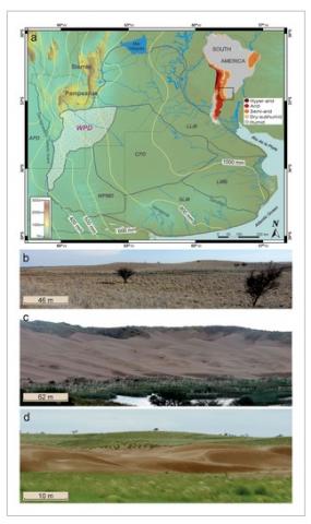
The temperate grassland and cultivated soils of the Western Pampa of Argentina, southern South America, developed over Late Pleistocene–Holocene aeolian sands, shifted from semiarid to dry subhumid in the past ~120 years with an increase of precipitation variability, concordant with significant changes in agricultural land use. This Western Pampean Dunefield (WPD) is a dormant system, mostly stabilised by vegetation and agriculture, with extensive reactivations during the 1930s ‘Pampas Dust Bowl’ and the current formation of new dunes in an anthropogenically disturbed landscape. Analysis of the complex assembled aeolian landforms of the WPD with quantification of vegetated dunes provides new associations for landscape evolution and aims to contribute to science-based land management. The methodology includes field surveys, remote sensing imagery, dune morphometry, site stratigraphy and optically stimulated luminescence (OSL) dating. Main aeolian bedforms are blowout dunes and sinuous ridges, associated with aeolian streaks, sand sheets and fluvial-aeolian plains. The blowout dunes (simple, compound and complex) reach tens to thousands of meters in diameter, have commonly superimposed dunes on the depositional lobes, and sand transport directions towards the NW, NNW-NNE and SW. The sinuous ridges, continuous for 100s m to 1–2 km, have nearly symmetrical profiles and two main crest orientations (NW-SE and SW–NE). Cross-dune patterns and associated OSL chronology allow proposing a morphostratigraphy scheme of compound and complex blowout dunes developed during the Late Pleistocene and growing since then, while sinuous ridges probably accreted in the Holocene. Young blowout dunes are penecontemporaneous and post-date sinuous ridges, reflecting significant aeolian reworking processes. Patches of barchanoid and reversing dunes superimposed on blowout dunes, which have been active since at least the CE 1970s, and the new dune formation in the past two decades, often in intensively cultivated areas, indicate that synergistic biogeomorphic processes may yield irreversible changes in semi-arid to dry subhumid landscapes with an aeolian legacy.
Cecilia Mariel Spagnuolo, Augusto Ernesto Rapalini, Ricardo A. Astini, Sabrina Y. Fazzito
2 025
Journal of South American Earth Sciences Volume 157, May 2025
Permian times were characterized by distribution of land masses forming a supercontinent called Pangea. Although its existence has been accepted for many decades, there is still debate about its configuration. In order to provide new constraints on the position of Gondwana during late Paleozoic times, a paleomagnetic study was carried out on Carboniferous-Permian red beds exposed in the Famatinian Ranges, western Argentina (27°43′S 67°58′W). Eighty four oriented samples (11 sites) were submitted to standard stepwise demagnetization procedures. Magnetic analysis was complemented by acquisition of isothermal remanent magnetization (IRM), backfield curves and anisotropy of magnetic susceptibility (AMS) on selected specimens. Inclination shallowing due to compaction was evaluated by application of oriented acquisition of IRM and demagnetization experiments. The high-temperature magnetic components of sites are characterized by southward declinations with positive inclinations that yield a positive fold test. A new paleomagnetic pole is calculated and suggests an age of magnetization between 300 and 270 Ma, thatmatches with a Pangea B distribution although a Pangea A2 model can not be ruled out if the magnetization age is restricted to 280-270 Ma.
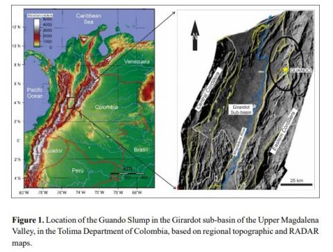
A detailed geological study of the Guando oilfield has identified a modern landslide phenomenon that significantly alters the previous structural model and affects production challenges. The multi-compositional nature of the oil-bearing Cretaceous sequences of the Villeta Group, the rugged relief, the climatic incidence, and seismic activity in the Upper Magdalena Valley trigger the Guando Slump, which adjusts the topography to levels of greater stability. The previous tectonic model of the Guando oilfield was based on the superposition of an internally disturbed block by the Boquerón thrust. However, in its westernmost segment, this structure shows angular incompatibilities with the expected horizontal stress fields. Therefore, based on a detailed 3D interpretation of geological maps, DEM, and available geophysical data, we propose that this segment must be associated with the surface of the underlying detachment of the Guando Slump. The horizontal displacement of the landslide, ranging from 1 to 2 km, deforms and collapses the wells that reach the underlying productive reservoirs. This study describes the relationship of this new tectonic model of the Guando oilfield, considering the westernmost segment of the Boquerón thrust as a detachment of the Guando Slump. This real-life example, if properly monitored, will contribute to a better management of the possible causes and consequences of technical problems encountered in the Guando oilfield exploration and prevent catastrophic risks to the production facilities.
As humans expanded across the globe, the Americas were the last continents to be colonized. While debates persist regarding the timing and mechanisms of this process, it is widely accepted that by the Pleistocene–Holocene transition, the New World was populated from Alaska to Tierra del Fuego. During this period, hunter-gatherer societies demonstrated remarkable cultural and adaptive diversity, particularly in subsistence strategies and technological innovations. The colonization of the Americas offers valuable insights into population dynamics, human–environment interactions, species extinctions, and adaptive capacities. From an interdisciplinary perspective that combines an isotopic analysis of megafaunal remains with archaeological evidence, this study examines human interactions with Pleistocene fauna in the south–central region of South America’s Southern Cone. Isotopic analyses provide information about the diets, adaptations, and climatic challenges faced by megafaunal communities. Archaeological evidence reveals that humans utilized megafauna and other Pleistocene species for food and tool production. These findings are supported by evidence such as cut marks and bone tools, but also by sealed sediment layers and/or indisputable associations of lithic artifacts. This research contributes to our understanding of human dispersal in the Southern Cone during the colonization of the Americas, shedding light on the regional environments and adaptive strategies of early populations.
Paulo Marcos, Mathias Hueck, Sebastian Oriolo, Emiliano Manuel Renda, Guadalupe Arzadún, Pablo Diego González, Leonardo Benedini, Mauro Geraldes, Juan Pablo Lovecchio, Emilio Rojas Vera &Franco Moreno
2 025
International Geology Review, 1–24, 3 de jul 2025
The geodynamic evolution of the basement of the Patagonian Precordillera (Argentina) began with middle to late Paleozoic tectonometamorphic and magmatic events. Subsequent exhumation was triggered by brittle-ductile to brittle deformation from Mesozoic to Cenozoic times thought the thermal evolution of this stage is relatively unexplored in most basement areas. In this study, we assess the cooling-thermal evolution in the upper crust, providing new thermal models based on fission-track and (U-Th)/He thermochronology data in zircon and apatite belonging to basement inliers of the Patagonian Precordillera. Most thermal models show similar decreasing time-temperature paths (t-T), from which three stages are distinguished. The Late Triassic – Jurassic stage exhibits a rather undefined cooling trajectory and cooling rates (0.56–2.2°C/My), which are temporally correlated with high magmatic productivity and extensional deformation related to extensional tectonic settings. This first stage might have resulted from coupled tectonothermal processes consisting of extensional faulting and high-temperature gradient. Subsequently, a relatively fast temperature decrease (2.75–5°C/My) for the late Early Cretaceous to Paleocene is likely related to a compressive stage associated with the growth of the early Andean Orogen. Low cooling rates (<1°C/My) characterize the third stage correlative with Palaeogene arc magmatism. Although this low cooling rate remains until present day conditions, one thermal model denotes a final high cooling rate during Miocene linked to the second compression stage of the Andean Orogen. Results thus indicate that one of the most significant exhumation event recorded in basement rocks of the Patagonian Andean foreland took place during the late Early Cretaceous – Paleocene stage.
Roberto A. Scasso, Sebastián Oriolo and Klaus Wemmer
2 025
Journal of the Geological Society Volume 182, Number 4, 7 July 2025
This work presents new K–Ar and X-ray diffraction illite data for Middle Jurassic sedimentary sequences (i.e. Mount Flora and Camp Hill formations) of the Antarctic Peninsula, providing the thermal evolution of the Mesozoic tectonic history of the Antarctic Peninsula and adjacent regions. Samples of the Camp Hill Formation at Camp Hill Peninsula (Botany Bay) yielded middle Permian–early Triassic K–Ar ages that are associated with upper–lower anchizonal conditions, reflecting the input of detrital illite derived from the Trinity Peninsula Group. Maximum temperatures of up to c. 175°C, constrained by vitrinite reflectance data, were achieved during the Jurassic–Early Cretaceous burial of the Camp Hill Formation, contemporaneously with magmatism. In contrast, samples of the Mount Flora Formation show Late Cretaceous ages mainly related to upper anchizonal conditions, which result from hydrothermal processes linked with coeval igneous intrusions. Late Cretaceous arc magmatism was coupled with widespread hydrothermal activity that is well documented throughout the northern Antarctic Peninsula and South Shetland Islands.
M.L. Perez, F.N. Milanese, S.E. Geuna, P.R. Franceschinis, C. Puigdomenech, A. Folguera and A.E. Rapalini
2 025
Quaternary Research , Volume 124 , March 2025 , pp. 153 - 170
A paleomagnetic study of basaltic lava flows exposed in the northern Neuquén Cordillera, southernmost Central Andes, along the Antiñir-Copahue fault zone (ACFZ), involved 25 sites of the Cola de Zorro Formation (Pliocene–Early Pleistocene) along two different sections. The sites show exclusive normal polarity, corresponding to the Late Pliocene Gauss chron (3.6–2.6 Ma). The angular standard deviation of virtual geomagnetic poles (VGPs; ASD = 14.8°) is consistent with the expected values from recent geomagnetic models, in opposition to anomalously low dispersion found in previous studies in Pleistocene VGPs of reverse polarity from neighboring areas to our study zone. Mean paleomagnetic directions for Bella Vista (Dec = 0.0°, Inc = −50.0°, α₉₅ = 7.6°, K = 36.7, N = 11) and Río Huaraco sections (Dec = 354.9°, Inc = −57.0°, α₉₅ = 7.5°, K = 55.7, N = 8) do not show tectonic rotation around vertical axes. Combining and regrouping our and previous data by area confirmed the absence of tectonic rotations in the Huaraco-Trohunco block and a statistically significant clockwise rotation of 14.4° ± 10.3° of three adjacent tectonic blocks located south of our study locality in Pleistocene times. These results suggest that strike-slip deformation along some sections of the ACFZ was significant in the Pleistocene structural evolution of this region.
Carlos A. Ballivián Justiniano; Maricel G. Rodríguez; Taras L. Panikorovskii; Manuela E. Benítez; Clemente Recio; Cinthia P. Ramos; Mabel E. Lanfranchini; Florencia Di Salvo
2 025
American Mineralogist (2025) 110 (9): 1382–1398
In the Sauce Chico Complex (Neoproterozoic–middle Cambrian age; Ventania System, Argentina), polymetamorphosed carbonate xenoliths known as the Loma Marcelo skarn are hosted in an Ediacaran peraluminous granite. The skarn has three types of vesuvianite, namely a, b, and c, with different colors, habits, and/or mineral assemblages. They were studied through petrographic microscopy, electron microprobe, inductively coupled mass and atomic emission spectrometry, Raman and Mössbauer spectroscopy, X-ray diffraction (powder and single-crystal), and fluid inclusion and stable isotope analyses. The average composition of the Loma Marcelo skarn vesuvianite is [...] and corresponds to vesuvianite sensu stricto. Negligible amounts of XNa and TB were detected. Only Zn, Sr, Ce, La, and Sn are in concentrations >50 ppm. Through single-crystal XRD, the crystal structures of vesuvianite types a and b were refined in the P4/nnc space group (domains with P4/n symmetry are also present). Type c vesuvianite could not be satisfactorily refined; however, a P4/n symmetry is suspected. By comparing the Loma Marcelo skarn vesuvianite cell parameters with those of other vesuvianites worldwide, it becomes clear that symmetry does not influence these parameters. Based on Raman, single-crystal XRD data, and structural and chemical characteristics, formation temperatures of 550 °C (type b), 450 °C (type a), and 300–400 °C (type c) were estimated. The δ values of ca. +11.9‰ calculated for these temperatures from δ18O values determined on vesuvianite concentrates and vesuvianite-water fractionation factors are compatible with a peraluminous granitic source. The Loma Marcelo skarn vesuvianite appears to reflect a retrograde process related to the crystallization of the Ediacaran granite hosting the metasomatized xenoliths. During a subsequent protracted Permian tectono-metamorphic event, biphasic secondary fluid inclusions were trapped at ca. 270–339 °C (ca. 250 MPa) from low salinity metamorphic fluids. Stable isotope determinations of H and O on vesuvianite concentrates indicate that the interaction with magmatic and metamorphic aqueous fluids promoted modifications in the 2H/1H ratios of the hydroxyl groups from the W sites, whereas the 18O/16O ratios of the silicate groups were not substantially modified. Notably, the vesuvianite structure is highly stable, remaining unchanged after formation. This stability suggests that vesuvianite-group minerals could serve as a reliable XRD-based thermometer.
Hugo Tickyj, Marcos Emanuel Bahía, Viviana Martínez, Eliana Vanesa Saguas, Renata Nela Tomezzoli, María Alejandra Fernández, José Kostadinoff
2 025
Revista de la Asociación Geológica Argentina, 82(2), 234-242
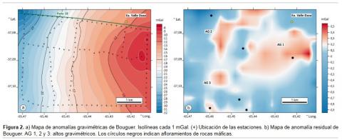
A geophysical survey was conducted in the Estancia Valle Daza, Utracán Department, La Pampa Province, within a 5 × 4 km area of mining interest due to the presence of critical minerals, including monazite and metagabbros with nickel anomalies. The study involved gravimetry, magnetometry, gamma-ray spectrometry, and electrical self-potential methods and represents a continuation of previous regional geophysical investigations. Residual gravity data revealed three gravimetric highs, spatially associated with bipolar magnetic anomalies reaching up to 300 nT. The largest of these anomalies is oval-shaped, with a major axis of approximately 2 km. These gravimetric and magnetic features are interpreted as responses to mafic rocks, either sub-outcropping or located at shallow depths within the crystalline basement of the study area. Gamma-ray spectrometry identified two zones with equivalent uranium contents of up to 10 ppm, comparable to the levels recorded in granitic mylonites rich in monazite from this sector. Additionally, the self-potential method was applied along a shear zone characterized by granitic mylonites containing monazite, providing further insight into the area's subsurface features. The results of this integrated geophysical approach highlight the value of combining multiple methods to enhance critical mineral prospecting in Estancia Valle Daza.