El Dr. Augusto Rapalini, Investigador de nuestro Instituto, ha sido designado Socio Honorario por la Asociación Geológica Argentina.
Nos alegra mucho comunicarles que nuestro compañero el Dr. Augusto Rapalini, Investigador Superior del CONICET, Profesor Asociado de la UBA, ex director del IGeBA ha sido designado Socio Honorario por la Asociación Geológica Argentina el día 4 de junio de 2025.
¡El IGeBA felicita al Dr. Rapalini por esta designación!
REVISTA DE LA ASOCIACIÓN GEOLÓGICA ARGENTINA, Vol. 81 No. 3 (2024): Special Issue on the Jurassic of Argentina
Se analizó la distribución de Haentzschelinia ottoi (Geinitz) en los afloramientos de la Formación Lajas (Jurásico Medio) de la locali-dad de arroyo Carreri en la cuenca Neuquina. Se consideraron más de 200 ejemplares y su relación con las facies y con otras trazas fósiles, se determinaron los índices de icnofábrica (ii) y de bioturbación sobre el plano de estratificación (bpbi). H. ottoi aparece en facies de frente deltaico dominado por acción fluvial (FA2) y en facies de frente deltaico dominado por acción fluvial con influencia de mareas (FA3). En general, las trazas fósiles corresponden a depositívoros (H. ottoi, Planolites, ?Taenidium, ?Parahaentzschelinia), indicando el desarrollo de una icnofacies de Cruziana empobrecida. En particular H. ottoi aparece formando asociaciones monoic-noespecíficas con ii/bpbi = 2-3 (en FA2 y FA3) o asociaciones con otras trazas de depositívoros con ii/bpbi = 3-4 (solo en FA3). El desarrollo de una u otra se deberían a variaciones en la descarga de sedimento y a diferencias de salinidad. Las asociaciones con mayor diversidad y ii/bpbi = 3-4 estarían favorecidas por un aumento en la salinidad bajo la influencia de las mareas y tiempo suficiente para la colonización del sustrato por otros depositívoros. Baja salinidad o frecuentes descargas de sedimento habrían dado origen a asociaciones monoicnoespecíficas de H. ottoi.
The distribution of Haentzschelinia ottoi (Geinitz) is studied from the Lajas Formation (Middle Jurassic) of the Neuquén Basin in Arroyo Carreri. For this work were considered more than 200 specimens and their relation with the facies and other trace fossils, as well as the ichnofabric index (ii) and the bedding plane bioturbation index (bpbi) were determined. H. ottoi appears in fluvio-dominated delta front (FA2) and fluvio-dominated delta front to delta plain with tidal influence (FA3). In general, trace fossils correspond to deposit-feeders (H. ottoi, Planolites, ?Taenidium, ?Parahaentzschelinia), suggesting the development of an impoverished Cruziana ichnofacies. In particular, H. ottoi constitutes monoichnospecific associations with ii/bpbi = 2-3 (in FA2 and FA3) or more diverse associations with other trace fossils and ii/bpbi = 3-4 (only in FA3). The development of one association or another depends on the interplay between sediment discharge and salinity conditions. More diverse associations with ii/bpbi = 3-4 would be favoured by a rise in salinity under the influence of tides and enough time for substrate colonisation by other deposit-feeders. Lower salinity conditions or high frequency of sediment discharge would have given rise to monoichnospecific associations of H. ottoi with ii/bpbi = 2-3.
María Gabriela Torres, Nora A. Rubinstein, Anabel L.R. Gómez, María Celeste D'Annunzio
2 025
Ore and Energy Resource Geology Volume 18, April 2025
The Yalguaraz gondwanic porphyry-type deposit is located at the eastern margin of the Frontal Cordillera in the Andes of Argentina. In this deposit, two alteration-mineralization stages (early and late) were recognized. The early stage is linked to the intrusion of a dacitic porphyry that produced pervasive potassic alteration (biotite - K–feldspar - quartz - andalusite) along with EB, A, and B veins. Mineralization occurs mainly disseminated in the dacitic porphyry and minor in A and B veins and consists of pyrrhotite, chalcopyrite, pyrite, and minor molybdenite. The late stage led to pervasive phyllic alteration (sericite + quartz + pyrite ± chlorite ± rutile ± chalcopyrite) along d-type veinlets and subsequent tourmalinization. The presence of hypogenic pyrrhotite and the scarce magnetite could indicate that it would be genetically associated with reducing magmas although the lack of ilmenite series oxides in the precursor magmatic rocks suggest that the reducing character of the mineralizing magmas was acquired during the magma evolution. δ18O and the Pb isotopic composition of the mineralizing magma confirm continental crust assimilation processes in its genesis whereas whole rock geochemistry suggests the involvement of marine sediment which would support the change in the redox conditions of the magma precursor of the porphyry-type mineralization.
REVISTA DE LA ASOCIACIÓN GEOLÓGICA ARGENTINA, Vol. 81 No. 3 (2024): Special Issue on the Jurassic of Argentina
En este trabajo se describen especímenes del género Didemnoides Bonet y Benveniste-Velásquez provenientes de distintas seccio-nes del intervalo Tithoniano–Berriasiano de la cuenca Neuquina (Formación Vaca Muerta). Didemnoides ha sido interpretado como espículas de ascidias afines a la familia Didemnidae Giard, por lo que este registro representa la primera documentación de tunicados para el Tithoniano–Berriasiano de la cuenca Neuquina. La presencia de espículas de ascidias didémnidas permite inferir el desarrollo de sustratos duros, alta disponibilidad de nutrientes, baja turbidez del agua y escaso influjo de agua dulce. La ubicación de los niveles portadores de Didemnoides dentro del marco estratigráfico secuencial de la Formación Vaca Muerta, evidencia su desarrollo durante los cortejos transgresivos, donde prevalecen estas condiciones.
In this work, specimens of the genus Didemnoides Bonet and Benveniste-Velásquez are described from different sections of the Tithonian-Berriasian interval of the Neuquén Basin (Vaca Muerta Formation). Didemnoides has been interpreted as spicules of ascidians related to the family Didemnidae Giard, so this record represents the first documentation of tunicates for the Tithonian – Berriasian of the Neuquén Basin. The presence of spicules of didemnid ascidians allow to infer the development of hard substrates, high availability of nutrients, low water turbidity and low fresh water influx. The location of the Didemnoides-bearing levels within the sequence stratigraphic framework of the Vaca Muerta Formation evidences its development during transgressive system tracts, where these conditions prevail.
Alonso Muruaga, Pablo Joaquin; Saade, Luis Sebastián; Bravo, Gonzalo Gabriel; Alonso, Guido Ezequiel; Babot, María Judith; Garcia Lopez, Daniel Alfredo
2 024
Publicación Electrónica de la Asociación Paleontológica Argentina, Vol. 24 Núm. 2 (2024)
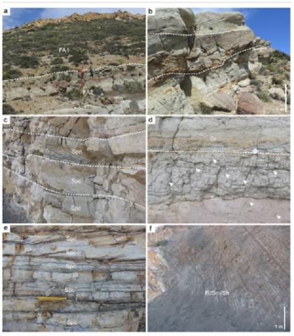
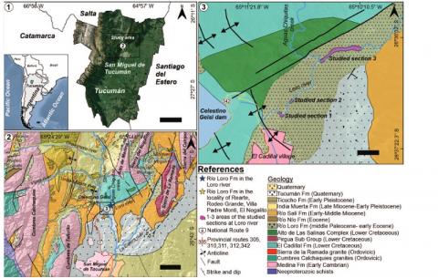
Paleoenvironmental and paleoecological aspects of the Río Loro Formation (Paleogene, northwestern Argentina) were analyzed. In thetype locality, four main sedimentary facies were recognized. Facies 1 (coarse-grained to pebbly amalgamated sandstones) record sedimentationin braided channels. Facies 2 (structureless to faintly laminated mudstones) and Facies 3 (interbedded mudstones with sandstones) are ascribedto deposition in distal to proximal floodplain settings, respectively. Facies 4 (coarse to medium-grained sandstone) is interpreted as deposited inmeandering channels. Insect trace fossils, ascribed to nesting structures, were recognised particularly in facies 1 and 4. The recognized facieswere grouped in a main facies association which allows interpretating a deposition in a complex multi-channel fluvial system with relatively stablemuddy floodplain areas. Within this system, seasonal humid to dryer conditions favored biota substrate colonization and soil-forming processes.Well-preserved mammalian and reptilian remains were recognized in sandy mudstone deposits of Facies 3, showing low weathering stages (mainlystages 1 and 2) and the absence of signs of abrasion. These aspects, along with the presence of some articulated remains and their integrationwith the paleoenvironmental framework, suggest that skeletal pieces suffered an early burial after partial disarticulation, possibly by splays duringmajor floods. The inferred habits of some of the taxa recorded are consistent with proximity to freshwater sources, vegetated areas, andseasonality. This multidisciplinary approach contributes to the understanding of paleoenvironmental and paleontological attributes of the Río LoroFormation and represents a basis for future surveys on this unit and its remarkable fossil record.
Se analizaron aspectos paleoambientales y paleoecológicos de la Formación Río Loro (Paleógeno, noroeste argentino). Se reconocieron cuatro facies sedimentarias. La Facies 1 (areniscas gruesas a guijarrosas amalgamadas) registran sedimentación en canales entrelazados. La Facies 2 (fangolitas masivas o débilmente laminadas) y la Facies 3 (fangolitas intercaladas con areniscas) reflejan depositación en planicies de inundación distales a proximales, respectivamente. La Facies 4 (areniscas gruesas a medias) documenta depositación en canales meandriformes. Trazas fósiles de insectos atribuibles a estructuras de nidificación fueron reconocidas en las facies 1 y 4. Las facies fueron agrupadas en una asociación de facies principal que refleja sedimentación en un sistema fluvial multicanalizado complejo con áreas de planicie de inundación fangosa relativamente estables, donde condiciones estacionales húmedas a más secas favorecieron la colonización del sustrato por parte de la biota y procesos de formación de suelo. Se reconocieron restos de mamíferos y reptiles bien conservados en depósitos de la Facies 3, con estadios bajos de meteorización (principalmente etapas 1 y 2) y ausencia de signos de abrasión. Asimismo, la presencia de restos articulados y su integración con el marco paleoambiental, sugieren desarticulación parcial y enterramiento temprano, posiblemente a partir de desbordes durante inundaciones. Los hábitos inferidos para los taxones registrados muestran consistencia con la proximidad a fuentes de agua dulce y áreas vegetadas, así como estacionalidad. Este enfoque multidisciplinario contribuye a la comprensión de los atributos paleoambientales y paleontológicos de la Formación Río Loro y representa una base para futuros estudios sobre esta unidad y su notable registro fósil.
Hugo G Nami, Karina V Chichkoyan, Juan Yataco Capcha et José L Lanata
2 023
Bulletins et Mémoires de la Société d'Anthropologie de Paris, 35 (2) | 2023
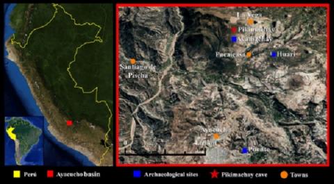
The Pikimachay cave in south-eastern Peru had an important role in archaeological discussions concerning the first peopling of South America, and the Southern Andes in particular. The excavations by Richard MacNeish in 1969-1970 identified a sequence of possible but controversial Late Pleistocene human occupations up to historical times. As a part of a research programme aiming to re-assess the Late Pleistocene remains from this site, we made taphonomic observations on a sample of bones (n=40) from the lower strata (layers h to k) as follows: h (n=17), h1 (n=6), i (n=4), i1 (n=7), j (n=5), and k (n=1). The conventional uncalibrated radiocarbon dates initially obtained suggest that these layers span a period of ~14.0 to 25.0 thousand years before present (kybp). Each bone was thoroughly examined to determine the nature of modifications to them, and to describe alterations and the general condition of the specimens in order to identify possible anthropic intervention. For this purpose, we examined the surface modifications indicating fresh or post-depositional fractures, the different kinds of marks, weathering, and the presence of manganese staining. We concluded that several bones (n=8) from layer h showed various human-made modifications. We can therefore suggest that this new information justifies the assumption that the bones and lithic materials from layer h would have been produced during the Early Holocene/Late Pleistocene between ~≥9.0/10.0 and ~14.1, probably at ~14.1 kybp; an assumption that can also be considered for the stone remains from the underlying strata h1 that yielded a similar date. The bone remains from strata j to k do not show any human modifications. Furthermore, if the reported chronology and its association with the anthropic remains are true, the Pikimachay cave could still be relevant to the debate over the human colonisation of western South America that occurred within a similar timeframe during the postglacial era.
Kietzmann, Diego Alejandro; Iglesia Llanos, Maria Paula ; Iovino, Franco
2 023
Newsletters On Stratigraphy, Volume 56 Number 2 (2023), p. 157 - 1850
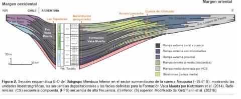
This work presents a regional biostratigraphic study on the calcisphere (calcareous dinoflagellate cysts) zones of the Tithonian–Berriasian in the Neuquén Basin, Western Argentina. This stratigraphic interval is mostly represented by a thick rhythmic succession of marlstone and limestone, with an abundant fossil content and a remarkable stratigraphic continuity along several hundred meters, known as Vaca Muerta Formation. This formation was originated in distal hemipelagic setting of a carbonate ramp and is one of the most important unconventional hydrocarbon reservoirs in the world. The detailed study of six stratigraphic sections, allowed the elaboration of a reliable biostratigraphic scheme and its correlation with Andean ammonites, calpionellids, and polarity zones. Calcareous dinoflagellate cysts within the Vaca Muerta Formation are moderately preserved. Despite that, twenty-nine species and nine biozones have been identified: Committosphaera pulla, Parastomiosphaera malmica, Colomisphaera tenuis, Colomisphaera fortis, Stomiosphaerina proxima, Stomiosphaera wanneri, Colomisphaera vogleri and Colomisphaera conferta. These results allow to contribute to an increasingly solid chronostratigraphic framework in the Neuquén Basin.
La Dra. Renata Tomezzoli ha sido distinguida con el Premio Asociación Geológica Argentina 2025 correspondiente a la disciplina Geofísica.
Nos alegra mucho comunicarles que nuestra compañera, la Dra. Renata Tomezzoli, Investigadora Principal del CONICET ha sido distinguida con el Premio Asociación Geológica Argentina 2025 correspondiente a la disciplina Geofísica, otorgado en reconocimiento a su gran trayectoria y a sus muy destacadas contribuciones científicas al desarrollo del Paleomagnetismo.
¡El IGeBA felicita a Renata Tomezzoli por este merecido premio!
Carlos A. Ballivián Justiniano, Sebastián Oriolo, Miguel A.S. Basei, Mabel E. Lanfranchini, Rodolfo O. Christiansen, Norberto J. Uriz, Sebastián E. Vázquez Lucero, Daniela A. Del Bono, Marnie A. Forster, Ricardo O. Etcheverry, Colombo C.G. Tassinari, Marcos A. Comerio, Claudia B. Prezzi
2 023
Journal of South American Earth Sciences Volume 124, April 2023
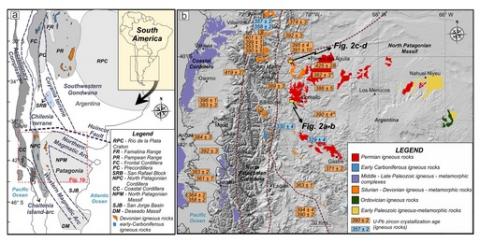
This work deals with the study of Gondwanide ductile shear zones developed in Neoproterozoic–middle Cambrian basement rocks of the Ventania System and possibly related to the reactivation of the Sierra de la Ventana Shear Zone. This reactivation was caused by the northeastward migration of the Gondwanide deformation from the North Patagonian Massif. The crustal shortening related to the Gondwanide Orogeny gave rise to thrusting of the Ventania System basement over Paleoproterozoic rocks of the Río de la Plata Craton. This work focuses on the study of muscovite ± quartz phyllonites of the Ventania System basement and quartz ± muscovite veins crosscutting basement and Paleozoic cover rocks of the system. Structural and magnetic surveys were performed in order to characterize the Gondwanide structures of the basement, while petrographic, X-ray diffraction, geochemical, and geochronological studies were carried out in order to investigate the nature, P-T conditions, element mobility, and age of these shear zone-related rocks. In the Sauce Chico Inlier, mylonitized basement rocks crop out along the western edge of the system, near the basement–Paleozoic cover interface, where the main structures are top-to-NNE reverse ductile shear zones with related phyllonites. Ductile shearing under greenschist-grade conditions (125–340 MPa and 300–400 °C) promoted major and trace element mobility. Phyllonites are the result of extreme hydrolysis of feldspars from the acidic igneous rocks of the basement, producing muscovite and releasing aqueous SiO2 later redeposited as quartz veins. These phyllonites developed in connection with reactivated contacts between basement units and also the basement–Paleozoic cover interface. New Rb–Sr quartz-muscovite and Ar/Ar muscovite ages for phyllonites and a quartz vein indicate a protracted tectono-metamorphic history mainly restricted to the Cisuralian (ca. 287 Ma), comprising regional folding and metamorphism, shear zone activity, vein-type mineralization, and syntectonic deposition of the Tunas Formation. Subsequent reactivations during the Lopingian (ca. 256 Ma) and probably in Late Triassic times (ca. 227 Ma) resulted from localized shearing along mylonitic belts.
Paulo Marcos, Emiliano M. Renda, Pablo D. González, Sebastián Oriolo, Nicolás Scivetti, Leonardo Benedini, Mauro Geraldes, Daniel Gregori, María Belén Yoya, Marcos Bahía
2 023
Tectonics, Volume42, Issue11 November 2023
In this contribution, we present new early middle Devonian igneous and metaigneous units with a major juvenile magmatic source input in the North Patagonian Massif, which were discovered through U-Pb and Lu-Hf zircon analyses. Afterward, we assessed their tectonic implications for northwestern Patagonia and then for southern South America, combining our results with available database information consisting of igneous crystallization ages and isotopic data of the Devonian to early Carboniferous magmatic units, tectonic-metamorphic analyses, and thermochronologic record. This study allows for distinguishing retreating and advancing subduction switching in northwestern Patagonia (38°30′ to 44°S) and a contrasting coetaneous evolution for basement outcrops exposed further north (27°30′ and 37°30′S). The early middle Devonian (400–380 Ma) northwestern Patagonian magmatism is characterized by widespread magmatism and positive εHf–εNd linked to forearc and backarc magmatism that evolved within a retreating subduction stage. A tectonic switching toward advancing orogeny stage began in the late Devonian, evidenced by a lull in magmatic activity with a negative εHf–εNd trend, possibly contemporaneous with the first tectonic-metamorphic event in western Patagonia. An early Carboniferous magmatic gap, followed by the subsequent development of the main foliation in the basement during the Carboniferous-Permian period, denotes the acme of this contractional stage. In contrast, the Devonian period in the northern segment is characterized by mostly negative εHf–εNd values, reverse shear zone activity in the foreland, and an inboard magmatism migration, evidencing a compressive tectonic setting that changed to an extensional configuration in the early Carboniferous with widespread arc magmatism development.