Ivana Laura Ozán, Sebastián Oriolo, María Ana Castro, Andrés Latorre
2 020
Raman spectroscopy - Volume51, Issue11 November 2020 Pages 2272-2289
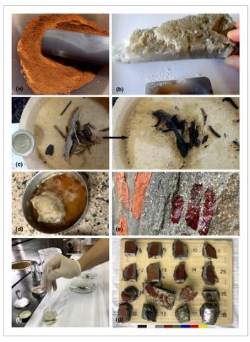
The present work analyzes Raman spectra of red, white, and black experimental paintings manufactured according to archeological and ethnographical data from Patagonia (South America), in order to provide reference patterns to better understand ancient signatures of rock art. Methodological insights are also presented, evaluating pitfalls and advantages of Raman spectroscopy. For this purpose, different pigments (hematite, gypsum, charcoal) mixed with binders and additives (Lama guanicoe fat, blood, urine, saliva, gypsum) were combined. Results show that, despite its high-spatial resolution, Raman analysis shows painting spectra often reflecting multicomponent signals at micrometer-scale. Results also indicate that fat and blood show well-defined spectra in paintings, whereas saliva and urine have negligible signatures, so a relatively high and low archeological preservation is expected, respectively. On the other hand, laser-related thermoalteration processes of fat and blood binders are triggered by the presence of hematite. This thermoalteration promotes conspicuous signatures in fat and blood binders related to disordered CC bonds (ca. 1,330 and 1,566 cm−1), which are also found in charcoal. Therefore, disordered carbon in the Raman spectra of rock art may not necessarily imply the presence of charcoal-bearing pigments but may also result from thermoalteration of organic materials. Evidence of blood migration through rock porosity is registered as well, with significant implications for rock art preservation, composition, and dating.
Rodrigo Javier Suárez, Pablo Diego González, Sebastián Oriolo, Martín Nazareno Parada, Miguel Esteban Ramos, Matías C. Ghiglione, Claudia Zaffarana, Juan Albano and Juan José Ponce
2 024
Journal of the Geological Society Volume 181, 17 May 2024
The Devonian to early Carboniferous western margin of Patagonia (South America) includes a NW–SE-trending magmatic arc associated with a NE-dipping palaeo-subduction zone. Along the Andean region of southern Patagonia, the Eastern Andean Metamorphic Complex developed in a forearc position and consists of a succession of very low- to low-grade metaturbidite–metabasic rocks emplaced from the Devonian to Carboniferous. There are significant uncertainties surrounding this metamorphic complex, mainly related to the tectonosedimentary setting of the basin and the subsequent conditions of deformation and metamorphism, which hinder our understanding of the orogenic architecture. To reveal the links between tectonics and metamorphism, we conducted a structural analysis and sampled metapelites to measure the illite crystallinity along a regional structural cross-section in the Eastern Andean Metamorphic Complex. Our analysis reveals broadly lower to upper anchizonal metamorphism roughly synchronous with deformation along northwards-verging thrusts. These findings support the development of a forearc hyperextended basin that was subsequently closed during the Gondwanide Orogeny (late Paleozoic), a model that reconciles previous proposals suggesting passive margin v. back-arc basin models. This closure led to the emplacement of supra-subduction zone ophiolites and turbidites over the continent through the landwards migration of brittle–ductile reverse shear zones.
Revista de la Asociación Geológica Argentina Vol. 81 No. 2 (2024)
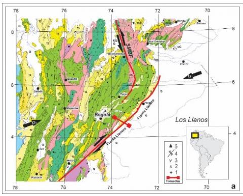
El Frente Llanero de la Cordillera Oriental de Colombia exhibe un gran potencial hidrocarburíferoremanente basado en la interpretación de objetivos exploratorios esencialmente controlados por la morfología de diversos tipos de trampas tectónicas. Estas estructuras reconocidas en superficie y subsuelo sufrieron los efectos de la inversión transpresional andina delfallamiento normal asociado con el acomodamiento de losdepocentros mesozoicos. El balanceo de transectas a partir de limitada información, esencialmente desubsuelo, es una técnica ampliamente utilizada para la interpretación basada mayoritariamente en fallamientos subhorizontales y subparalelos a la compresión actuante. Sin embargo, para facilitar su elaboración se simplifican principios mecánicos y geométricos básicos al considerar las secuencias involucradas tabulares y con respuestas de formativas uniformes, a pesar de involucrarse litologías heterogéneas con reologías diferentes. Adicionalmente, no se contemplan las relaciones espaciales entre el campo de esfuerzos actuante y las fracturas (diaclasas y fallas) establecidas por la Ley de Anderson. Incluso, no se admiten escenarios evolutivos múltiples coninversiones o componentes transcurrentes al no aprovecharse las discontinuidades previas del basamento subyacente orientadas preferentemente para su reactivación. En este trabajo, se resumen las principales características tectónicas del Frente Llanero y se discuten aspectos estructurales del fallamiento basados en modelos analógicos, fundamentos mecánicos de la deformación, influencia de discontinuidades preexistentes, así como los postulados y limitaciones de los modelados analógicos en la concepción de balanceos. De esta manera, se proponen herramientas de interpretación tectónica alternativas y menos subjetivas aplicadas al estudio del potencial exploratorio de recursos hidrocarburíferos del Frente Llanero Colombiano y regiones tectónicas similares.
The Frente Llanero of the Eastern Cordillera of Colombia exhibits a great remaining hydrocarbon potential based on the interpretation of exploratory objectives essentially controlled by the morphology of its various tectonic traps. These structures recognized on surface and subsurface suffered the effects of Andean transpressional inversion of normal faulting associated with the accommodation of Mesozoic depocenters. Based on limited surface and subsurface information, the balanced cross sections are the widely used technique for interpretation based mainly on subhorizontal faulting placed subparallel to compression. Basic mechanics and geometric principles are simplified to facilitate their making. These include considering the involved sequences as perfectly tabular with uniform deformation responses, despite their heterogeneous lithologies with different rheologies. Additionally, the spatial relationships between the dominant stress field and the fractures (joints and faults) established by Anderson's Law are not contemplated. Furthermore, multiple evolution sequences with inversions or transcurrent components are not allowed since the previous discontinuities of the underlying basement located in a preferred orientation for their reactivation are not considered. This paper summarizes the main tectonic characteristics of the Colombian Frente Llanero, and structural aspects of faulting based on analog models, mechanical principles of deformation, the influence of pre-existing discontinuities, and the postulates and limitations of analog modeling concepts are discussed. In this way, alternative and less subjective tectonic interpretations are proposed to study the exploratory potential of the hydrocarbon resources of the Colombian Frente Llanero and similar tectonic regions.
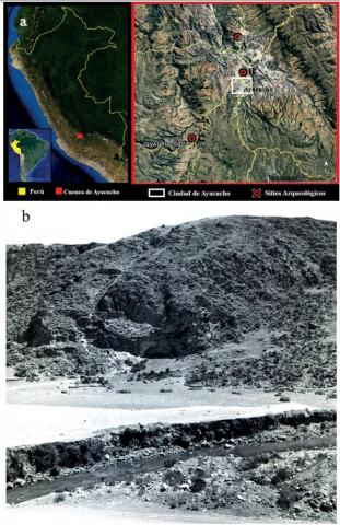
Entre 1966 y 1968 Richard MacNeish lideró el programa “Ayacucho Archaeological-Botanical Project” en la cuenca de Ayacucho, provincia de Huamanga. Allí encontraron más de 450 sitios con ocupaciones humanas. Uno de ellos es el alero Jaywamachay que se destaca por el registro arqueológico exhumado. Los trabajos de excavación realizados en 1969 y 1970 detectaron evidencia de las ocupaciones humanas más antiguas de la región. Sobre las mismas solo se publicaron en detalle especímenes correspondientes a los cazadores-recolectores pertenecientes a las ocupaciones humanas del último milenio del Pleistoceno y que utilizaban puntas Fell. Dado a la importancia de esos hallazgos, se organizaron y estudiaron los restos líticos (n = 4,388) contenidos en los doce estratos más tempranos del sitio que presentan una antigüedad que oscila entre 11,603 y 9,556 años calibrados antes del presente. Los análisis permitieron identificar dos claros conjuntos artefactuales de características tecno-morfológicas y cronologías diferentes. Debido a las similitudes de los instrumentos y su asociación a fechados calibrados consistentes, los restos arqueológicos de los estratos H a J fueron dejados entre ~≥10,3 - 9 kya por cazadores-recolectores del Holoceno Temprano. Los vestigios de J1 a J3 corresponden a ocupaciones humanas que utilizaron puntas Fell y vivieron durante la transición Pleistoceno/Holoceno entre ~≥12,6 - 10,2 kya. Estos registros convierten a Jaywamachay como uno de los sitios más significativos para conocer los grupos humanos más tempranos que habitaron la cuenca de Ayacucho en el pasado.
Carlos Oscar Limarino, Salomé Candela Salvó Bernárdez, Sergio Alfredo Marenssi, Patricia Lucia Ciccioli, Silvia Nelida Césari, Luis Ferreira
2 023
Revista de la Asociación Geológica Argentina, Vol. 80 No. 3,Aug 22, 2023
En este trabajo se define una nueva unidad litoestratigráfica de edad pérmica en la Cuenca Paganzo para la que se sugiere el nombre de Formación Puerta de Las Angosturas. La nueva formación está compuesta principalmente por fangolitas y areniscas abigarradas, entre las que se intercalan recurrentes niveles de chert, calizas y tobas. Los afloramientos en el área de Las Angosturas (sierra de Narváez, provincia de Catamarca) son seleccionados como su estratotipo, en el que fueron distinguidas y descriptas seis secciones estratigráficas. La sección estratigráfica 1, formada por areniscas rojas y moradas masivas o laminadas (23 m de espesor), cubre mediante una discordancia erosiva de bajo relieve a areniscas eólicas de la Formación De La Cuesta. La sección 2, de 55 m de espesor, cubre transicionalmente a la sección 1 o traslapa sobre los bancos rojos de la Formación De La Cuesta, y comprende fango-litas y areniscas muy finas de color morado a pardo grisáceo. La sección 3 se caracteriza por la presencia de bancos de areniscas y calizas interlaminadas con milimétricos niveles de chert, alcanzando el conjunto unos 110 m de espesor. La sección 4 (70 m) muestra características similares a la 3, pero se distingue por el predominio de fangolitas sobre areniscas y por la presencia de delgados y recurrentes niveles de tobas. La sección 5 es muy delgada, de aproximadamente 15 m, y muestra un marcado cambio litológico con respecto a las secciones previamente descriptas, ya que se encuentra formada por areniscas medianas a gruesas con estratificación entrecruzada. Finalmente, la sección 6 (76 m) corresponde a una secuencia de grano fino en la que alternan fangolitas, calizas y escasos bancos de tobas. El conjunto es cubierto en discordancia por bancos rojos de la Formación Talampaya. Las secciones 2, 3 y 4 de la Formación Puerta de Las Angosturas han brindado asociaciones palinológicas correspondientes a la Biozona Lueckisporites/Weylandites que sugieren una edad kunguriana para ese tramo estratigráfico.
A new Permian lithostratigraphic unit denominated Puerta de Las Angosturas Formation is defined for the Paganzo Basin. The new formation is mainly composed of variegated mudstones and sandstone beds, among which several levels of chert, limestone, and tuff are interstratified. The area of Las Angosturas (Sierra de Narváez, Catamarca province) is set as its type section, in which six stratigraphic intervals were distinguished and described. Stratigraphic interval 1, formed by massive or laminated red and purple sandstones (23 m thick), overlies eolian deposits belonging to the De La Cuesta Formation through a low-relief erosive unconformity. Interval 2 comprises 55 meters of purple to grayish-brown mudstones and fine-grained sandstones that transitionally cover interval 1 or overlap on the red beds of the De La Cuesta Formation. Interval 3 is made of interbedded sandstone and limestone beds with millimeter levels of chert; the whole interval reaches 110 m of thickness. Interval 4 (70 m) shows similar lithological characteristics to 3 but differs in the predominance of mudstones over sandstone and the presence of thin and recurrent tuff levels. Interval 5 is very thin, 35 m thick, and shows marked lithological changes concerning those previously described intervals since it is formed by medium- to coarse-grained cross-bedded sandstones. Finally, interval 6 (76 m) corresponds to a fine-grained sequence in which mudstones, very fine-grained sandstones, limestone, and a few tuff beds alternate. The Puerta de Las Angosturas Formation is covered in unconformity by the red beds of the Talampaya Formation. Intervals 2, 3, and 4 of the Puerta de Las Angosturas Formation have provided palynological assemblages corresponding to the Lueckisporites/Weylandites biozone that suggests a Kungurian age, at least for the lower half of the unit.
Patricia L. Ciccioli, Sergio A. Marenssi, Salomé C. Salvó Bernárdez, Carlos O. Limarino
2 023
Journal of South American Earth Sciences Volume 128, August 2023
This paper analyzes an extended eolian field developed during the Oligocene-Early Miocene along the eastern flank of the Andes. This eolian episode, herein named OMEB (Oligocene-Miocene Eolian Belt), is recorded in several units, including Mariño, Pachaco, Cuculí, Vallecito, El Crestón, Tambería, Angastaco, Quiñoas, Las Chacras, and Vizcachera Formations. Eolian accumulation occurred in five environments: 1. Sand sheet and extradune, 2. Dune field, 3. Dune and draas, 4. Deflationary eolian fields, and 5. Wadi and fore-eolian areas. While sand sheet deposits are composed of horizontally laminated and low-angle cross-bedded sandstones, dune and draas environments comprise giant- and large-scale cross-bedded sets and dune fields by stacked sets of cross-bedded sandstones. In contrast, the deflation field environment exhibits low-relief irregular surfaces carved in dune and extradune environments. Finally, the wadi and fore-eolian deposits correspond to the eolian dune interbedded with fluvial conglomerates and muddy sediments deposited mainly by low-energy fluvial currents on the interdunes. Towards the end of the Early Miocene, the OMEB declined in almost all the foreland area, and fluvial and lacustrine sediments replaced eolian deposits. Although the stratigraphic expression of this change was different along the region, three principal patterns of change are recognized: 1. Different degrees of fluvial incisions, 2. Fluvial replacement of eolian deposits without evidence of significant incision, and 3. interbedding of eolian, fluvial, and occasionally playa-lake deposits. In the first pattern, conglomerates forming lenticular channels abruptly incise into the dune deposits. In pattern 2, fluvial channels are dominantly sandy, and incision surfaces are poorly defined. The third pattern, contrasting with the two previously described, results from the recurrent interstratification of eolian, fluvial, and playa lake deposits. This type of eolian-fluvial transition was studied in detail in the Tambillos creek (Northeastern Sierras de Los Colorados), where a sequential model for the eolian fluvial transition using the position of the water table is proposed. This model allows defining four primary states: 1. Low water table, 2. High water table (below the surface), 3. High water table (at or slightly above the surface) with partial flooding and damming, and 4. Runoff for fluvial channels.
Salomé C. Salvó Bernárdez, Carlos O. Limarino, Sergio A. Marenssi, Patricia L. Ciccioli
2 023
Journal of South American Earth Sciences Volume 128 , August 2023
This paper presents a new U–Pb zircon age of 253.40 ± 1.06 Ma for the middle part of the Talampaya Formation, which is consistent with the previously reported dating of 252.38 ± 0.22 Ma at the top of the unit. The age herein presented was obtained from a tuff level intercalated into a fluvial sequence formed by finning-up cycles of massive conglomerates, cross-bedded sandstones, and laminated sandy mudstones interpreted as deposited by sandy meandering rivers with dominant sandy floodplains. In this context, a vitric tuff from a floodplain located 140 m from the base of the unit provided the zircons dated by the combination of LA-ICP-MS (Laser Ablation – Inductively Coupled Plasma – Mass Spectrometry).
The radiometric age of 253.40 ± 1.06 Ma confirms the relocation of the Talampaya Formation in the Late Permian and demonstrates that at least the upper half and probably the whole of this unit was deposited during the Lopingian, a time interval scarcely represented in South America. This assumption is consistent with the age of 249.66 ± 0.11 Ma (early Triassic) reported in the overlying La Veteada Formation.
The new age presented has paleoclimatic implications regarding the worldwide climatic aridification event that occurred at the end of the Late Paleozoic since it gives a relatively precise approximation to the onset of the aridization in this part of Gondwana during the Lopingian (circa 252.38 Ma).
Analysis of high-resolution seismic profiles from the central Beagle Channel enabled the recognition and characterization of several post-glacial subaqueous mass transport deposits in the subsurface of Bahía Ushuaia, offshore the city of Ushuaia (Argentina). These deposits are located at different stratigraphic levels and are embedded in the stratified sedimentary sequence within a deep trough, suggesting a recurrent occurrence. Up to eleven deposits have been identified, with four major events that involved estimated sediment volumes ranging from 12 to 57 million m3. The latter are associated with megaturbidite deposits up to 10 m thick. Two of the largest events postdate the early Holocene unconformity of marine transgression. The seismic data suggest a different dynamic behaviour of these four main events, with erosional, strongly disintegrating and longer-lasting pre-marine transgression mass transport events compared to the post-early Holocene deposits. Several of the deposits appear to have a common origin due to earthquake-induced failures of submerged glaciofluvial deposits or from tributary deltas. In addition, a preliminary analysis of the potential generation of tsunami waves associated with the largest submarine failures was carried out using numerical models. The results show that at least three of them would have the potential to generate dangerous waves with maximum heights of up to 1–2 m in the port of Ushuaia and estimated run-up heights between 2 and 8 m. Although further detailed analysis is recommended, particularly with regard to a more sophisticated modelling approach and refinement of the resolution of bathymetric and topographic data for strategic areas.
Revista de la Asociación Geológica Argentina, 80(1), 129-145 (2023)
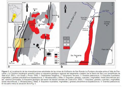
Las vetas wolframíferas de las minas San Román y La Puntana constituyen una serie de cuerpos biextendidos cuarzosos que se distribuyen en una faja de unos 2 km de largo, con potencias submétricas y que fueron explotados entre las décadas del 40 y 70 mediante trincheras y socavones. Se disponen subparalelamente sobre el contacto del encajante metamórfico de la Formación San Luis con el Granito La Escalerilla, el cual ha sido asignado al Paleozoico inferior, ambas unidades típicas del basamento cristalino de la Sierra de San Luis. Se propone que, tardíamente, durante su emplazamiento ocurrieron cambios volumétricos que promovier-on fenómenos termotectónicos vinculados con el control estructural de la mineralización por el desarrollo de espacios potenciales, subparalelos y cercanos al contacto, el cual estaba controlado por las anisotropías planares preexistentes del encajante esquistoso. Además, la contracción térmica diferencial del cuarzo durante el pasaje de β a α, con respecto a los demás constituyentes mineralógi-cos de la cúpula del granito, produjo durante su enfriamiento, una disminución de la presión con ebullición de los fluidos hidrotermales neumatolíticos enriquecidos en elementos inmiscibles. Este mecanismo generó, en las cúpulas del granito La Escalerilla, porosidad que permitió la concentración de fluidos enriquecidos en wolframio, los cuales migraron hacia las vetas suprayacentes con significa-tiva ausencia de greisinificación y pegmatitización. Se propone que la potencia de las vetas está en relación con la disminución volumétrica del intrusivo a lo largo de su contacto, con tendencia a adelgazarse a medida que se alejan del mismo.
The tungsten-bearing veins of San Román and La Puntana mines constitute a series of quartz biextended bodies along about two km with potencies of the sub metric order that were exploited between the 40s and 70s through trenches and subsurface works. They are arranged in parallel on the contact of the metamorphic host of the San Luis Formation with the La Escalerilla Granite assigned to the lower Paleozoic, both units of the crystalline basement of the Sierra de San Luis. It is proposed that volumetric changes occurred during its late emplacement favored thermotectonic phenomena linked to the structural control of the mineralization by developing potential spaces subparallel to the vicinity of its controlled contact by the pre-existing planar anisotropies of its shale host rocks. In addition, the differential thermal contraction of the quartz during the passage from b to a, with respect to the other mineralogical constituents of the granite dome, produced during its cooling, a decrease in pressure with boiling of the pneumatolytic hydrothermal fluids enriched in immiscible elements. This mechanism generated in the domes of the La Escalerilla granite porosity and the concentration of fluids enriched in tungsten that migrated towards the overlying veins with a significant absence of greissinification and pegmatization. It is proposed that the power of the veins is related to the volumetric decrease of the intrusive throughout its contact and that they tend to thin out as they move away from the contact of the intrusive body.
Aquatic Sciences: Research Across Boundaries,Volume 86, article number 49, (2024)
The Punta Rasa Natural Reserve encompasses a system of small coastal lagoons, which are developed in a sand spit that limits with the coast of the southern end of the outer estuary of the Río de la Plata. The aim of this work is to estimate the discharge flow of groundwater from the environments of beach ridges and dunes adjacent to the coastal lagoons and evaluate how it influences the hydrochemistry of the associated lagoons and marshes. For this, a monitoring network was defined covering sampling points in the sea/estuary, coastal lagoons, and groundwater located in transects that perpendicularly cross the main body of the coastal lagoon. In each transect, water levels, pH, electrical conductivity, and 222Rn were measured in situ and samples were collected to determine the major ions. The analysis of groundwater flow profiles and 222Rn values allowed the identification of the existence of groundwater discharge flows in the three coastal lagoons. It was also possible to estimate the different components of the groundwater discharge flow and the velocity and discharge flows. Regarding chemistry, although coastal lagoons and marsh water are saline and show Na-Cl hydrochemical facies that reflect tidal flow contribution, in the areas of groundwater discharge from the dunes and beach ridges there is a decrease in the electrical conductivity of the marsh water associated with an increase in the concentration HCO−3+CO−23. This is because the water from the dunes and beach ridges is fresh to saline and has higher concentrations of HCO−3+CO−23 than sea water. Hydrodynamic differences in the three lagoons are associated with the relationship between tidal flow contributions—groundwater discharge responds to morphological changes owing to the evolution of the sand spit that encompasses the lagoons.