Fermin Palma, Sebastián Principi, Juan Pablo Ormazabal, Luana Acosta, José Isola, Donaldo Mauricio Bran, Federico Esteban, Alejandro Tassone
2 024
Deep Sea Research Part I: Oceanographic Research Papers Volume 208, June 2024
Our recent echo-character analysis of the Tierra del Fuego Continental Margin, focusing on Sloggett Canyon and the interfluve with Valentín Canyon, provides insights into contemporary sedimentary processes. Utilizing high-resolution seismic profiles obtained from the R/V Austral in 2017, we categorized sub-bottom echoes into 10 distinct types, shedding light on various processes such as hemipelagic deposition, mass wasting events, glacial influence, and the impact of bottom water masses. By integrating data from the GLORYS12V1 model (1993–2020), CTDs from the World Ocean Database, and sediment samples, we analyze the interaction between bottom currents, seafloor topography, and sediment characteristics. We conclude that the flow of the Subantarctic Water Mass acts as an active transport of coarser sediment from the continental shelf into the canyon, maintaining the Sloggett Canyon's activity, while the flows of the Upper and Lower Circumpolar Water Masses contribute to contourite formation along the eastern canyon flank and the erosion of the lower interfluve, leading to the generation of distinctive longitudinal scours. Additionally, in the continental rise, the interaction of water masses with the seafloor influences the redistribution of the deep-sea fans from the Sloggett and Valentín canyons towards the northeast. This study significantly enhances our understanding of the sedimentary dynamics in this area, establishing the basis of the sedimentary distribution for future interdisciplinary studies and for setting a new baseline in marine protected areas.
Alfonsina Tripaldi, Ivana L. Ozán, Guillermo Heider, María J. Orgeira, Steven L. Forman
2 024
Journal of Quaternary Science: Volume 39, Issue 2, February 2024, Pages 289-308
Stabilized and active dunes and sand sheet deposits abound in a small lake-dotted semi-arid region of the Western Pampean Dunefield, Argentina. Here, a multi-scale and multi-proxy study of three sites, across a hydrologic gradient from lakes to a dryland with groundwater levels at more than 25 m depth, analyzes calcareous and ferruginous rhizoliths, calcareous crusts, hypocoatings, pedogenic carbonate and amorphous Mn-oxide precipitates within blowout dunes. These palustrine-related features indicate significantly wetter conditions that allowed the development of shallow lakes and expanding wetlands during the Pleistocene–Holocene transition, limited by associated optically stimulated luminescence ages between ca. 14.7 and 11.6 ka. These wetter conditions, also identified in other nearby proxy records, may be associated with a strengthened South American Monsoon System, potentially during the Younger Dryas Chronozone, though other geological, ecological and climatic forcings cannot be ruled out with available data. Such a scenario lacks a modern analogue, since current hydrologic excess, evidenced in the formation of lakes and new rivers, is not observed in the localities which record paleolakes. This study underlines the variable conditions for pronounced hydrologic excess in semi-arid eolian environments in western Argentina with complex ecological, anthropogenic and climatic linkages.
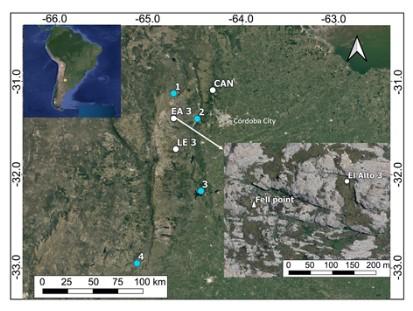
We present a projectile point recovered from the archaeological locality of El Alto, province of Córdoba, Argentina. Its techno-morphological characteristics and the raw material used in its preparation are described. The results allow it to be included in the typological group of Fell projectile points. The data provided enrich the discussion about the first stages of occupation in the region, characterized by a meager archaeological record belonging to the final Pleistocene and the beginning of the Holocene.
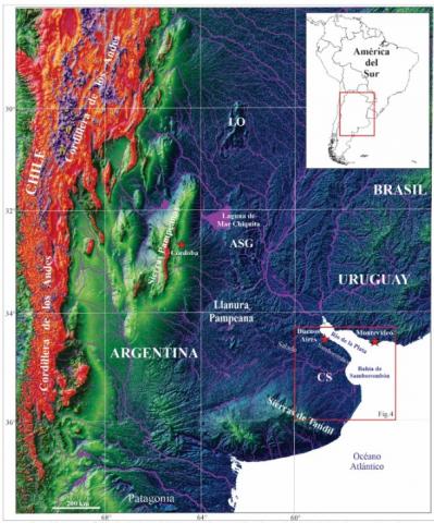
A Baía de Samborombón localizase no litoral bonaranse, no estuário do Rio da Prata. Apresenta característica morfologia semicircular, com aproximadamente 100 km de extensão, entre Punta Piedras (ao Norte) e o Cabo San Antonio (ao Sul). A coincidenciacom a subjacente Bacia de Salado permite traçar relações tempo-espaciais entre sua morfologia e sua história tectonossedimentar. A exumação andina aporta sedimentos até a margem passiva atlântica. No Plioceno houve uma diminuição na taxa de sedimentação devido à colmatação dos ambientes da Planície Pampeana. A interposição do leque aluvial de Córdoba contra o Alto San Guillermo gerou a Laguna Mar Chiquita e modificações na drenagem. Assim, com taxa de subsidencia de ~0,09 mm/ano da Formação Las Chilcas (Maastrichtiano-Paleoceno), reduz-se a ~0,005 mm/ano da Formação Puelches (Plioceno-Pleistoceno), com média de 0,042 mm/ano para as formações eocênicas Los Cardos e Olivos. O balanço progressivo negativo entre a taxa de sedimentação vs. subsidenciadetermina que a Bacia de Salado seja um depocentro faminto (altamente receptor) que propiciou o avanço do mar terra adentro na Baía de Samborombón. Dessa forma, apresentam-se cordões conchíferos, áreas úmidas, baixios e pântanos onde o desenvolvimento de altos a partir do Sul favoreceram para a progressiva continentalização.
Samborombón Bay is located on the Bonaerense coast, in the estuary of the River Plate. It has a characteristic semicircular morphology, approximately 100 km long, between Punta Piedras (to the north) and Cape San Antonio (to the south). The coincidence with the underlying Salado Basin makes it possible to trace time-space relationships between its morphology and its tectonosedimentary history. Andean exhumation brought sediments to the Atlantic passive margin. In the Pliocene there was a decrease in the rate of sedimentation due to the filling in of the environments of the Pampean Plain. The interposition of the Córdoba alluvial fan against the San Guillermo High generated the Mar Chiquita Lagoon and changes in drainage. Thus, the Las Chilcas Formation (Maastrichtian-Paleocene) sedimentation rate of ~0.09 mm/year is reduced to ~0.005 mm/year of the Puelches Formation (Pliocene-Pleistocene), with an average of 0.042 mm/year for the Eocene Los Cardos and Olivos formations. The progressive negative balance between the rate of sedimentation vs. subsidence determines that the Salado Basin is a hungry (highly receptive) depocenter that has led to the advance of the sea inland into Samborombón Bay. In this way, there are conch strands, wetlands, shallows and marshes where the development of highlands from the south favored progressive continentalization.
María Cecilia Marchi, Teresita Montenegro, Patricia Anzil
2 024
Revista de la Asociación Geológica Argentina, Vol. 81 No. 1 (2024)
El Plutón Urcuschún se ubica en la unidad morfoestructural Precordillera Central, provincia de La Rioja, Argentina. En el sector cen-tro-oeste del cuerpo intrusivo la composición es cuarzo-monzodiorítica con contenidos de SiO2 y K2O propios de la serie calcoalcalina alta en potasio, es metaluminoso y corresponde a los granitoides de arco volcánico. La intrusión generó metamorfismo de contacto y metasomatismo en las rocas de caja, afectando a las calizas de la Formación San Juan (Ordovícico Inferior a Medio) y a los niveles basales del Grupo Paganzo (Carbonífero tardío). Se generaron, consecuentemente, un skarn portador de Fe y Mo en las calizas ordovícicas y en el conglomerado calcáreo de la base del Grupo Paganzo, y rocas metasedimentarias en el contacto con las formaciones Guandacol y Tupe (Grupo Paganzo). En la zona estudiada del plutón, se evidencia alteración hidrotermal, potásica, fílica y, predominantemente alteración propilítica. La edad de cristalización de la facies porfiroide con enclaves microgranulares es pérmica (270.39 ± 0.45 Ma), determinada por método U/Pb en circones, coincidente con la edad de otros cuerpos ígneos del área.
The Urcuschún hill is located in the morphostructural unit of the Central Precordillera, in the central-west region of La Rioja province, Argentina. In this hill, an intrusive body called the Urcuschún Pluton outcrops, which induces contact metamorphism and metasomatism in the limestones of the San Juan Formation and in the basal levels of the Paganzo Group. As a result, meta-sediments are generated from the transformation of sedimentary protoliths, along with a Fe and Mo skarn in the Ordovician limestones and, primarily, in the calcareous conglomerate at the base of the Paganzo Group.
The objective of this study is to present the petrographic and geochemical characterization of the Urcuschún Pluton. Additionally, its crystallization age was determined using the U/Pb method on zircons, resulting in a Permian age (270.39 ± 0.45 Ma).
Norma Ratto, Carolina C. Méndez, Patricia L. Ciccioli, Mara Basile, Pablo Cruz
2 024
Boletín de la Sociedad Chilena de Arqueología N°56 (2024)
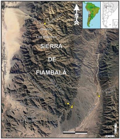
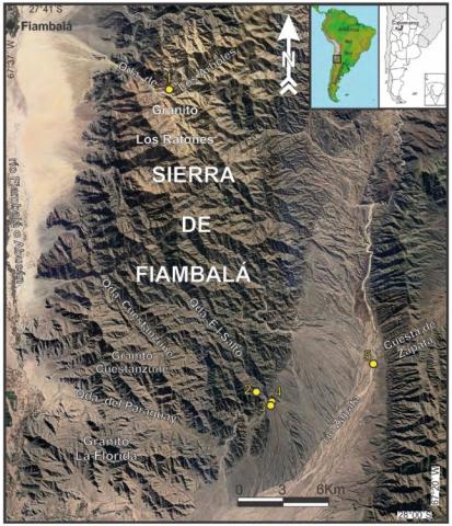
Aportamos a la definición de las fases de extracción y procesamiento de minerales de la cadena operativa de la minería prehispánica en el oeste de Tinogasta (Catamarca, Argentina). Desarrollamos escalas macro y micro para caracterizar geológica y geoquímicamente los recursos minerales de minas localizadas en las quebradas de Los Árboles y El Salto ubicadas en la vertiente occidental y oriental de la sierra de Fiambalá, respectivamente. Presentamos nuevas formas de procesamiento de las menas de minerales llevadas a cabo en el sitio El Salto-1, que se caracteriza por presentar grabados rupestres asociados con morteros con profundas oquedades y pesados machacadores. La metodología articula la realización de: (i) nuevas prospecciones dirigidas a la toma de muestras y el registro de potenciales lugares de extracción de minerales o antiguos piques y (ii) análisis geoquímicos sobre las muestras de roca y un artefacto lítico (machacador), para integrar los resultados con los antecedentes geológicos existentes y disponibles para la sierra de Fiambalá. Sostenemos como hipótesis que esos morteros fueron utilizados para el chancado de rocas para separar los minerales con valor económico.
We contribute to the definition of the mineral extraction and process-ing phases of the operational chain of pre-Hispanic mining in the west of Tinogasta (Catamarca, Argentina). We develop macro and micro scales to characterize geologically and geo-chemically the mineral resources of mines in the Los Árboles and El Salto creeks on the western and eastern slopes of the Sierra de Fiambalá. We present new ways of processing mineral ores at the El Salto-1 site, characterized by presence of rock en-gravings associated with mortars with deep cavities and heavy pounders. The methodology articulates: (i) new surveys for sample collecting and to record potential mineral extraction sites or old pits and, (ii) geochemical analyses of rock samples and a lith-ic artefact (pounder), to integrate the results with the existing and available geological background of the Sier-ra de Fiambalá. We posit that these mortars were used for crushing rocks to separate the minerals with eco-nomic value.
Jorge G. Lozano, Donaldo M. Bran, Sebastian Ramirez, Florencia B. Restelli, Stefania Bunicontro, Federico Esteban, Marco Menichetti, Emanuele Lodolo, Alberto Renzulli, Juan F. Vilas, Alejandro Tassone
2 024
Geothermics, Volume 119 , May 2024, 102963
The Termas de Río Valdez is a low-enthalpy geothermal area located in the southernmost South America, Argentina. The area is characterized by a geologic history of changing tectonic regimes that resulted in superimposed structures. The mechanism and pathway for fluid migration of the thermal springs remains uncertain. A geophysical survey of electrical resistivity tomography profiles combined with magnetometric measurements and lineament mapping were aimed at modelling the shallow structural setting of the area. Data suggest that the springs are controlled by two systems of fractures and faults affecting the bedrock and that the rising of the thermal waters is due to transtensional structures.
Geochemistry, Geophysics, Geosystems, Volume25, Issue 6, June 2024
Generic Mapping Tools (GMT) is a well-known set of software originally developed for geosciences, allowing scientists in climate and solid earth disciplines to routinely create publish-ready maps and graphics. However, GMT users rarely make animations despite their undeniable benefit for understanding and teaching dynamic processes. As reading habits shift from print to digital, capitalizing on animations for illustrating scientific concepts is more accessible than ever. In the latest GMT version (6.5), we have added and refined the movie-making modules, alleviating the time-consuming steps that would hinder GMT users from making such animations. In this paper, we will explain how GMT's “movie” module works and provide six representative examples, from basic to more advanced, to show some of its key features. We hope our presentation will encourage the masses to routinely create animations for their publications.
Manuel López, Florencia Milanese, Leandro D'Elia, Andrés Bilmes, Joaquín Bucher, Rodrigo N. Feo, Micaela García, Manuel Calvo-Rathert, Augusto Rapalini, Juan R. Franzese
2 024
Basin Research, Volume 36, Issue 1, Jan 2024
The Patagonian Andean foreland system includes several intermountain basins filled with a Miocene non-marine record deposited under syn-tectonic conditions related to the Andean uplift and a regional climate change triggered by a rain shadow effect. Many of those basins, such as the Collón Cura basin in Neuquén Province, Argentina, present a well-preserved fluvial record (i.e. the Limay Chico Member of the Caleufú Formation). Sedimentological and palaeomagnetic studies have allowed the interpretation of coeval transverse distributary fan and axial mixed-load fluvial systems deposited between 10.6 ± 0.2 and 12.8 Ma. The basin infill arrangement shows that, while the axial mixed-load fluvial system exhibits an aggradational stacking pattern, the transverse distributary fluvial fan system denotes three different orders of stratigraphic patterns: (i) large-scale progradation of the transverse fluvial fan system over a time scale of 106 year; (ii) intermediate-scale progradational–retrogradational transverse intra-basinal fluvial fan episodes over a time scale of 105 year; and (iii) small-scale transverse lobe progradation over a time scale of 105–104 year. These patterns were interpreted as transverse sediment flux variations triggered by variable external forcings. To decouple those forcings, we estimated the Collón Cura basin equilibrium time at 3–5 × 10⁵ year and compared it with the time scale over which different external forcings varied in the Patagonian Andean and foreland regions during Miocene times. Large-scale progradation is linked to an increase in sediment flux triggered by a long-term tectonically driven exhumation forcing associated with the Miocene Patagonian Andean contractional phase. Intermediate-scale progradational–retrogradational episodes are linked to variations in sediment flux due to a mid-term tectonic forcing associated with the western fault system activity. The small-scale fan lobe progradation is related to increases in sediment flux triggered by indistinguishable short-term autogenic processes and/or high-frequency tectonic and climatic forcings. This contribution shows the applicability and limitations of the basin equilibrium time concept to decouple external forcings from the geological record, considering their magnitude, nature and time scale, as well as the basin characteristics.
Roberto A. Scasso, J. Ramezani, I. Escapa, A. Elgorriaga, I. Capelli
2 022
International Journal of Earth Sciences, Volume 111, pages 891–904, (2022) 2022
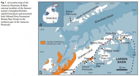
The spectacular fossil plant assemblage preserved in the non-marine Mount Flora Formation of the northern Antarctic Peninsula represents the diverse Jurassic fora that once covered the Gondwanan continents at high paleolatitudes. The depositional facies of the formation plays a key role in the tectonic interpretations and basin evolution models that attempt to reconcile large igneous province magmatism, continental break up, and magmatic arc development throughout the Jurassic and Cretaceous. Limited U–Pb in situ geochronology reported from the Mount Flora Formation and adjacent units lack the necessary resolution to overcome ambiguous correlations and biostratigraphic discrepancies. We present two high-precision U–Pb zircon ages (CA-ID-TIMS method) from a distinct tufaceous interval of the Mount Flora Formation at Hope Bay, which document a terminal Middle Jurassic age (Callovian Stage) for the formation and its paleofora. In excess of 1400 new collected fossil plant specimens exhibit a highly diverse Jurassic plant association that dominated the Antarctic Peninsula nearly 17 million years after its disappearance from northern Patagonia. This suggests similar paleoecological conditions were established diachronously throughout basins of southern Gondwana, possibly facilitating foral migrations in response to local climate change. The depositional facies of the Mount Flora Formation, its age proximity to the marine Nordenskjöld Formation in the Antarctic Larsen Basin and its coincidence with a regional unconformity in the northern Patagonia point out to a complex interplay among magmatic arc development, tectonic extension and continental break up that dominated the geologic and paleoenvironmental evolution of southern Gondwana near the end of the Middle Jurassic.