
Premio - Dr. Vilas
El Dr. Juan Francisco Vilas, Profesor Emérito de la UBA e Investigador Superior ad-honorem del IGeBA, ha sido distinguido con el Premio Strobel 2026 por la Universidad de Buenos Aires.
El Dr. Juan Francisco Antonio Vilas, Profesor Emérito de la UBA e Investigador Superior ad-honorem del IGeBA, ha sido distinguido con el Premio Strobel 2026 por la Universidad de Buenos Aires, por sus extraordinarias cualidades intelectuales, sus importantes y pioneros aportes al desarrollo de la Geofísica y el Paleomagnetismo y su continua dedicación a la comunidad de las Ciencias de la Tierra.
El Dr. Juan Francisco “Finco” Vilas, Licenciado y Doctor en Física por la UBA ha sido pionero de los estudios paleomagnéticos, las reconstrucciones paleogeográficas y la tectónica de placas en la Argentina. Fue co-fundador, en 1964, junto al Ing. Daniel A. Valencio, del primer laboratorio de Paleomagnetismo de América Latina y promotor de la disciplina y de la creación de nuevos laboratorios en toda la región.
Desarrolló toda su carrera en la Universidad de Buenos Aires, donde alcanzó el cargo de Profesor Titular Plenario y a su jubilación el de Profesor Emérito. Ha sido miembro del CONICET por varias décadas donde llegó a Investigador Superior.
Ha destinado la mayor parte de su vida profesional a la aplicación de métodos geofísicos a la solución de problemas geológicos. Ha investigado en el campo del paleomagnetismo aplicado a las reconstrucciones paleogeográficas y tectónicas; la magnetoestratigrafía de cuencas continentales; las propiedades magnéticas de sedimentos de lagos, suelos y paleosuelos; el geomagnetismo y el magnetismo ambiental, así como a los relevamientos geofísicos (magnetometría, sísmica) tanto en tierra como en lagos y el mar.
Ha sido director de numerosas tesis doctorales, de tesis de licenciatura, de becarios e investigadores del CONICET y de la UBA.
Se desempeñó como Consultor Científico del CONICET, UBA, CONEAU, CIN, YPF, Obras Sanitarias de la Nación, CONEA, HIDRONOR e IBM.
Director de múltiples proyectos de investigación en geofísica, geodinámica y paleomagnetismo. Logró la instalación en la UBA del primer magnetómetro criogénico de América Latina.
Ha tenido una importante actuación en organismos internacionales, siendo vicepresidente de la Asociación Internacional de Geomagnetismo y Aeronomía (IAGA) por dos períodos y Miembro del Comité de Finanzas de la Unión Internacional de Geodesia y Geofísica (IUGG).
Consejero Superior de la UBA, Consejero Directivo de la FCEN y miembro del CODEP del Departamento de Cs. Geológicas, en varias oportunidades.
Autor de numerosos trabajos de investigación publicados en revistas de reconocido prestigio internacional como: Nature, Geophysical Journal International, Earth Planet Sc. Lett., Phys. Earth Planet Int., Tectonics, y otras.
Participó en la organización y/o presentación de trabajos en más de 80 congresos nacionales e internacionales.
¡El IGeBA felicita al Dr. Vilas por tan distinguido premio!


Nombramineto - Dr. Rapalini
El Dr. Augusto Rapalini, Investigador Superior ad-honorem del IGeBA, ha sido nombrado Profesor Emérito de la Universidad de Buenos Aires.

Felicitamos al Dr. Augusto Rapalini, Investigador Superior ad-honorem del IGeBA, por haber sido nombrado Profesor Emérito de la Universidad de Buenos Aires.
Un reconocimiento más que merecido a toda una vida dedicada a la docencia en Ciencias Geológicas, formando generaciones de profesionales.
¡El IGeBA felicita al Dr. Rapalini por este nombramiento!
Geología de los alrededores de la cuesta del Chihuido, Malargue, Mendoza
Grado: Tesis de licenciatura
Alumna: Cecilia Inés Gutiérrez
Año: 2020
Director: Dr. Diego A. Winocur
Codirector: Diego Kietzmann![]()
Resumen
Desde el punto de vista estratigráfico, se estudió el relleno de la cuenca Neuquinaen los alrededores de la cuesta del Chihuido, al suroeste de la provincia de Mendoza.Se reconocieron y describieron las unidades aflorantes así como se realizaron dosperfiles exploratorios de la Formación Vaca Muerta. Asimismo, se realizó un estudiosedimentológico de la mencionada formación hacia el norte de la zona de estudio, enel área del anticlinal El Morro, en donde se describieron cinco litofacies, dos facies yuna asociación de facies.Desde el punto de vista estructural, se identificaron patrones estructurales queafectaron la región de estudio mediante el mapeo de lineamientos y fracturas adistintas escalas, desde DEMs e imágenes satelitales hasta escala de afloramiento apartir de la realización de scanlines sobre las formaciones Vaca Muerta y Agrio.Desde el punto de vista geomorfológico, se realizó un exhaustivo análisis de losprocesos modeladores del paisaje. Se analizó la relación de la litología y la estructurasobre la evolución fluvial del paisaje.
Geología, geomorfología y manejo costero del balneario Monte Hermoso y zonas aledañas, partido de Monte Hermoso, provincia de Buenos Aires
Grado: Tesis de Licenciatura
Alumno: Martín Miguel Núñez Igarzábal
Año: 2019
Directora: Silvia Cristina Marcomini![]()
Co-director: Álvaro Rubén López![]()
Resumen
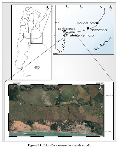
El objetivo de esta tesis final de licenciatura consistió en realizar un análisis geológico y geomorfológico de la zona costera ubicada en la localidad de Monte Hermoso, con el fin de caracterizar la dinámica de los subambientes costeros y de esta manera establecer medidas de manejo costero y estrategias de conservación para el uso sustentable de los recursos naturales. La zona costera estudiada presenta un campo de dunas, denominada barrera medanosa austral, dentro de la cual se reconocieron 3 unidades geomorfológicas dependiendo de su actividad eólica: campos eólicos activos, inactivos y semiactivos. El primero conformado por dunas de crestas barjanoides, crestas transversales, barjans, dunas incipientes y duna costera. Dentro del campo inactivo se identificaron dos sectores: uno septentrional, de mayor altura, dominado por dunas parabólicas, parabólicas complejas, dunas en voladura y dunas longitudinales por rotura de duna parabólica; y otro meridional de menor altura conformado por dunas parabólicas, parabólicas complejas, dunas en voladura. El campo eólico semiactivo está integrado en su mayor extensión por dunas degradadas a partir de un antiguo campo activo. En dicho campo se reconocen también dunas en voladura y parabólicas en menor medida que el campo inactivo. Como geoformas marinas se identificaron playas, plataformas de abrasión y acantilados cubiertos por rampa eólica. Mientras que el sistema fluvial se encuentra representado por ríos y lagunas de régimen permanente y transitorio y bajos inundados temporales. Los sedimentos actuales de playa están constituidos mayoritariamente por arena fina, moderadamente seleccionada y de distribución levemente asimétrica negativa. Los sedimentos que conforman el campo eólico activo y semiactivo son arenas finas moderadamente bien seleccionadas y distribución simétrica; mientras que el campo eólico inactivo se compone de arena fina, moderadamente bien seleccionada con curva de distribución simétrica a asimétrica negativa. Los sedimentos, tanto de duna como playa, están constituidos por arenas lítico-feldespáticas. Sobre las sedimentitas de las plataformas de abrasión, en el área del camping Americano al oeste de la ciudad de Monte Hermoso, se reconoció, en un nivel inferior, una nueva unidad estratigráfica de origen marino de composición carbonática de tipo grainstone intrabioclástica; mientras que en el nivel superior, se determinó una composición de arenisca feldarenita lítica. Se observó que en los últimos 50 años una degradación de la barrera medanosa costera debido a la expansión urbana y las construcciones en la zona costera, consistente en un aumento de la superficie vegetada y modificaciones en las morfologías de las dunas y aumento de los espacios interdunales. Se determinó como causas principales: la expansión del núcleo urbano, el aumento de la forestación y el incremento de las precipitaciones desde el año 1960. Por último, se observaron variaciones en las direcciones de migración de dunas, producto de la modificación de las frecuencias relativas de la dirección de los vientos. Se identificó una incidencia antrópica en los parámetros morfométricos y estadísticos de playa a lo largo de la línea de costa en dirección al este: se observó que, a mayor antropización, la granulometría de los sedimentos es ligeramente mayor, y disminuye el ancho y aumenta ligeramente la pendiente de playa. A partir del análisis morfológico a través del relevamiento de perfiles de playa se confeccionó un mapa de susceptibilidad a la erosión costera para la localidad balnearia, siendo las playas con mayor probabilidad a erosionarse las ubicadas en el sector del este de la ciudad, específicamente la zona entre las calles Antonio B. Costa y Esteban Dufaur (zona este barrio Dufaur) y el sector que comprende el barrio Villa Caballero hasta el frente del Faro Recalada. Con el objetivo de preservar el recurso turístico de la erosión costera, se recomendaron distintas medidas de plan de manejo costero para minimizar los impactos antrópicos, a fin de recuperar o mantener el equilibrio sedimentario costero. Se determinó que existen tres posibles focos de contaminación con distintas cargas contaminantes: a) el basurero a cielo abierto de Monte Hermoso, b) uso de pozos ciegos principalmente en el barrio Las Dunas y c) la planta de tratamiento de efluentes cloacales. Se propone realizar un monitoreo de elementos pesados y compuestos orgánicos en el agua subterránea y superficial (río Sauce Grande) para determinar y/o controlar la posible contaminación procedente del basurero y las lagunas de estabilización, como también controlar los pozos ciegos en el área sin cobertura de red cloacal (barrio Las Dunas).
Sedimentología del Zanjón de Apocango, Bolsón de Fiambalá, Catamarca
Grado: Tesis de licenciatura
Alumna: Delfina Fernández Molina![]()
Año: 2020
Directora: Dra. Patricia Ciccioli ![]()
Resumen
El Bolsón de Fiambalá es un valle intermontano limitado por el Sistema de Famatina al oeste, las Sierras Pampeanas al este y la Puna al norte. Este valle se caracteriza por la presencia de importantes depósitos eólicos principalmente en el centro y este, depósitos fluviales y aluviales. En particular, en este trabajo nos enfocamos en el estudio sedimentológico de la parte media del valle, donde se encuentra el Zanjón de Apocango. Entre los principales objetivos de interés se encuentran presentar un mapa geológico (1: 125.000) y un mapa geomorfológico (1: 140.000), analizar los datos de un año obtenidos por la estación meteorológica en la localidad de Medanitos, determinar los principales procesos de transporte y depositación del sistema fluvial del Apocango a partir de la descripción y realización de perfiles sedimentológicos y análisis granulométricos de sus depósitos, analizar la granulometría y composición de las megaóndulas y finalmente, de esta manera, caracterizar los ambientes sedimentarios desarrollados en el área.En base a los datos de la estación meteorológica Pegasus Plus 201 en Medanitos (10 km al NE de la zona de estudio), se obtuvo que las precipitaciones son escasas a nulas, de carácter torrencial y con picos máximos en el período estival, las temperaturas máximas ocurren en primavera (43°C) y las mínimas rondan los -8,8°C en otoño. Se registraron ráfagas de viento de hasta 69 Km/h con direcciones oeste y sudoeste.A raíz de la integración de los datos sedimentológicos y el análisis de los depósitos de los perfiles relevados a orillas del río Apocango se interpreta que dicho sistema fluvial, de carácter efímero y entrelazado, se caracteriza por depósitos areno-gravosos a gravo-arenosos depositados por flujos fluidos de alto régimen de flujo con alternancia de flujos hiperconcentrados no cohesivos.En la zona media del bolsón en las terrazas del Zanjón de Apocango, se reconocieron un total de cinco geoformas bien desarrolladas en un área de aproximadamente 29 km2 que denominamos megaóndulas. Se tratan de formas principalmente simétricas a levemente asimétricas hacia el este, con una altura promedio que varía de los 50 a 60 cm y un ancho de 8,50 a 9 m. En general, presentan crestas rectas con una dirección promedio E-O y el distanciamiento entre las megaóndulas aumenta de SE a NO. Se encuentran conformadas por depósitos bimodales: una cobertura gravosa con clastos tamaño guija gruesa (media: 1,74 cm y moda: 1,7 cm) y empaquetamiento abierto que protege de forma infrayacente a un manto de tamaño de grano arena media a fina (media: 2 φ), polimodal y pobremente seleccionada. Las gravas son subredondeadas a redondeadas con formas esféricas-proladas, esféricas-laminadas, esféricas, laminares, esféricas-discoidales y proladas predominantemente y presentan una esfericidad moderada. Composicionalmente, predominan las gravas de origen sedimentario, aunque también se reconocen de origen volcánico y granitoides.Se interpreta que el origen de las megaóndulas conlleva varias etapas: la migración inicial de óndulas S-R, la erosión de partículas finas causa un aumento del tamaño de grano, las óndulas coalescen y se configuran las megaóndulas. Finalmente, las partículas más gruesas cubren la cresta de la megaóndula formando una capa protectora o pavimento del desierto.Del análisis conjunto de los depósitos del río en las adyacencias de las megaóndulas, se interpreta que las gravas de ambos depósitos tendrían una proveniencia semejante dado que en ambos predominan los clastos de origen sedimentario y volcánico.